WITH A CELLPHONE AS MY GUIDE
location based services
Think of it as a divining rod for the information age. If you stand on a street corner in Tokyo today you can point a specialized cellphone at a hotel, a restaurant or a historical monument, and with the press of a button the phone will display information from the Internet describing the object you are looking at. The new service is made possible by the efforts of three Japanese companies and GeoVector, a small American technology firm, and it represents a missing link between cyberspace and the physical world. The phones combine satellite-based navigation, precise to within 30 feet or less, with an electronic compass to provide a new dimension of orientation. Connect the device to the Internet and it is possible to overlay the point-and-click simplicity of a computer screen on top of the real world. The technology is being seen first in Japan because emergency regulations there require cellphones by next year to have receivers using the satellite-based Global Positioning System to establish their location. In the United States, carriers have the option of a less precise locating technology that calculates a phone's position based on proximity to cellphone towers, a method precise only to within 100 yards or so. Only two American carriers are using the G.P.S. technology, and none have announced plans to add a compass. As a result, analysts say Japan will have a head start of several years in what many analysts say will be a new frontier for mobile devices. "People are underestimating the power of geographic search," said Kanwar Chadha, chief executive of Sirf Technology, a Silicon Valley maker of satellite-navigation gear. The idea came to GeoVector's founders, John Ellenby and his son Thomas, one night in 1991 on a sailboat off the coast of Mexico. To compensate for the elder Mr. Ellenby's poor sense of direction, the two men decided that tying together a compass, a Global Positioning System receiver and binoculars would make it possible simply to point at an object or a navigational landmark to identify it. Now that vision is taking commercial shape in the Japanese phones, which use software and technology developed by the Ellenbys. The system already provides detailed descriptive information or advertisements about more than 700,000 locations in Japan, relayed to the cellphones over the Internet. One subscriber, Koichi Matsunuma, walked through the crowds in Tokyo's neon-drenched Shinjuku shopping district on Saturday, eyes locked on his silver cellphone as he weaved down narrow alleys. An arrow on the small screen pointed the way to his destination, a business hotel. "There it is," said Mr. Matsunuma, a 34-year-old administrative worker at a Tokyo music college. "Now, I just wish this screen would let me make reservations as well." Mr. Matsunuma showed how it works on a Shinjuku street. He selected "lodgings" on the screen. Then he pointed his phone toward a cluster of tall buildings. A list of hotels in that area popped up, with distances. He chose the closest one, about a quarter-mile away. An arrow appeared to show him the way, and in the upper left corner the number of meters ticked down as he got closer. Another click, and he could see a map showing both his and the hotel's locations. Mr. Matsunuma said he used the service frequently in unfamiliar neighborhoods. But it came in most handy one day when he was strolling with his wife in a Tokyo park, and he used it on the spur of the moment to find a Southeast Asian restaurant for lunch. The point-and-click idea could solve one of the most potentially annoying side effects of local wireless advertising. In the movie "Minority Report," as Tom Cruise's character moved through an urban setting, walls that identified him sent a barrage of personally tailored visual advertising. Industry executives are afraid that similar wireless spam may come to plague cellphones and other portable devices in the future. "It's like getting junk faxes; nobody wants that," said Marc Rotenberg, director of the Electronic Privacy Information Center, a policy group in Washington. "To the degree you are proactive, the more information that is available to you, the more satisfied you are likely to be." With the GeoVector technology, control is given over to the user, who gets information only from what he or she points at. The Ellenbys have developed software that makes it possible to add location-based tourism information, advertising, mobile Yellow Pages and entertainment, as well as functions for locating friends. Microsoft was an underwriter of GeoVector development work several years ago. "We believe we're the holy grail for local search," said Peter Ellenby, another son of John Ellenby and director of new media at GeoVector. The GeoVector approach is not the only way that location and direction information can be acquired. Currently G.P.S.-based systems use voice commands to supplement on-screen maps in car dashboards, for example. Similarly, many cellphone map systems provide written or spoken directions to users. But the Ellenbys maintain that a built-in compass is a more direct and less confusing way of navigating in urban environments. The GeoVector service was introduced commercially this year in Japan by KDDI, a cellular carrier, in partnership with NEC Magnus Communications, a networking company, and Mapion, a company that distributes map-based information over the Internet. It is currently available on three handsets from Sony Ericsson. In addition to a built-in high-tech compass, the service requires pinpoint accuracy available in urban areas only when satellite-based G.P.S. is augmented with terrestrial radio. The new Japanese systems are routinely able to offer accuracy of better than 30 feet even in urban areas where tall buildings frequently obstruct a direct view of the satellites, Mr. Ellenby said. In trials in Tokyo, he said, he had seen accuracies as precise as six feet. Patrick Bray, a GeoVector representative in Japan, estimated that 1.2 million to 1.5 million of the handsets had been sold. GeoVector and its partners said they did not know how many people were actually using the service, because it is free and available through a public Web site. But they said they planned in September to offer a fee-based premium service, with a bigger database and more detailed maps. Juichi Yamazaki, an assistant manager at NEC Magnus, said the companies expected 200,000 paying users in the first 12 months. He said the number of users would also rise as other applications using the technology became available. NEC is testing a game that turns cellphones into imaginary fly rods, with users pointing where and how far to cast. Another idea is to help users rearrange their furniture in accordance with feng shui, a traditional Chinese belief in the benefits of letting life forces flow unimpeded through rooms and buildings. The market in the United States has yet to be developed. Verizon and Sprint Nextel are the only major American carriers that have put G.P.S. receivers in cellphone handsets. "The main problem is the carriers," said Kenneth L. Dulaney, a wireless industry analyst at the Gartner Group. Although some cellular companies are now offering location-based software applications on handsets, none have taken advantage of the technology's potential, he said, adding, "They don't seem to have any insight." Sirf Technology, which makes chips that incorporate the satellite receiver and compass into cellphones, said they added less than $10 to the cost of a handset. Several industry analysts said putting location-based information on cellphones would be a logical step for search engine companies looking for ways to increase advertising revenues. Microsoft has already moved into the cellular handset realm with its Windows Mobile software, and Google is rumored to be working on a Google phone. According to the market research firm Frost & Sullivan, the American market for location-based applications of all kinds will grow from $90 million last year to about $600 million in 2008. It is perhaps fitting that the elder Mr. Ellenby, a computer executive at Xerox Palo Alto Research Center in the 1970's, is a pioneer of geolocation technology. In the 1980's he founded Grid Computer, the first maker of light clamshell portable computers, an idea taken from work done by a group of Xerox researchers. A decade later a Xerox researcher, Mark Weiser, came up with a radically different idea — ubiquitous computing — in which tiny computers disappear into virtually every workaday object to add intelligence to the everyday world. Location-aware cellphones are clearly in that spirit. Article Link on The New York Times
Tuesday, October 31, 2006
NAVTEQ(R) Map Data Featured on New Delphi Portable Navigation Device
location based services
CHICAGO, Oct. 31 -- NAVTEQ (NYSE: NVT), a leading global provider of digital map data for location-based solutions and vehicle navigation, has been selected to provide map data for Delphi's new NAV200, a portable navigation device targeted to value-oriented consumers.
The Delphi NAV200, which is not much bigger than your hand, is ideal for first time navigation users. It comes with a preloaded SD card containing NAVTEQ map data, including a comprehensive database of the U.S. (including Hawaii, Alaska, and Puerto Rico) and Canada. Also included are 1.6 million of the most popular Points of Interest (POI's) including, restaurants, gas stations and ATMs making it easy to locate and route to many different destinations. NAVTEQ data delivers the highest levels of quality and precision. From turn restrictions to relative road crossing heights, NAVTEQ field teams capture more than 200 attributes, such as access restrictions, one-way streets, and speed categories. "Delphi and NAVTEQ's longstanding automotive relationship provides a solid foundation for the evolution of new product developments," said Dean VonBank, Vice President and General Manager, North American Vehicle Applications. "Together, we are committed to meeting driver expectations for accurate, value-oriented or budget-conscious portable navigation." The Delphi Nav200 is easy to use. The new NAV200 has plug and play capability, so the end user has no complicated map loading. The device comes with full NAVTEQ maps covering the USA and Canada all on a 1.5GB SD card. Voice guided directions via built-in speakers also make navigating simpler by eliminating the need to look at the screen once a preferred route is set. And with real time traffic readiness, city commuters have the option of adding Traffic Message Channel (TMC) programming, a subscription-based service that provides navigation systems with traffic information that is broadcast via radio station. By using TMC, which requires an optional adaptor, NAV200 will receive updated traffic information and adjust the route accordingly - helping drivers get to where they want to go on time. In addition to the sophisticated navigation features, NAV200 has popular entertainment functionality including a movie player, music player and picture viewer for use when not navigating. "Industry trends show the personal navigation market is expected to more than double over last year," stated Adiel Avelar, global navigation business line director, Delphi Consumer Electronics. "Part of this growth is driven by a convergence of different technologies such as navigation and entertainment. And the Nav200 uses the industry-leading NAVTEQ mapping database, which is trusted by popular online mapping services and automakers. This combination of advanced navigation features results in fast and accurate routing calculations-packaged together at a very competitive price." The Delphi NAV200 priced at $399.99 will be on display and demonstrated at the NAVTEQ booth (# 10209) during the 2006 S.E.M.A, Specialty Equipment Market Association, convention opening today in Las Vegas, Nevada which attracts over 100,000 attendees. For more information about Delphi NAV200, visit http://nav200.delphi.com . About DelphiDelphi was the first company to integrate a radio into the dashboard in 1936, the first to bring satellite radio to the vehicle in 2001 and the first to bring a portable satellite radio to the market in 2002. To date, Delphi has sold more than 14 million satellite radio receivers and accessories. In fact, three out of four satellite radio subscribers listen on Delphi hardware. Delphi continues to expand its in-vehicle and consumer electronics technologies and offers a broad portfolio of products to answer a wide variety of information and entertainment needs. For more information, visit http://www.delphi.com/media . About NAVTEQNAVTEQ is a leading provider of comprehensive digital map information for automotive navigation systems, mobile navigation devices, Internet-based mapping applications, and government and business solutions. NAVTEQ creates the digital maps and map content that power navigation and location-based services solutions around the world. The Chicago-based company was founded in 1985 and has approximately 2,100 employees located in 139 offices in 25 countries. http://www.navteq.com
The World is Watching: Image Mobile Search Gets Ready For Primetime
location based services
The concept of pairing camera-enabled mobile phones with mobile search to create a visual Google of the world around us is gaining traction, according to this blog post. An example is Camera Search! – a mobile marketing service developed by Bandai, a Japanese maker of toy, game and entertainment products, and D2C, a mobile marketing agency. In a nutshell, the service allows users to find and purchase content by capturing advertising for it with their cameraphones (this advertising can come from labels, CD covers, magazines, billboards, etc...) Satisfied with the uptake of image search to date the companies announced this week they will extend the Camera Search! scheme to promote mobile content around Crayon Shin-Chan, a popular Japanese cartoon. To download a free wallpaper users have to snap any scene in the opening credits of the cartoon on TV and send it to the service. The server then makes the match and delivers the content to users’ mobile phones.
Mobile operators outside of Japan have yet to tap into image search services – let alone link them with mobile content sales schemes. But that doesn’t mean image search doesn’t have a top-notch spot in the mobile search mix. To the contrary, more companies are joining the snap-and-search bandwagon (and let’s not forget Google’s recent acquisition of image search provider Neven Vision.) Perhaps the most original twist on image search comes from GeoVector, a U.S. provider of location-based services. It has quietly and cleverly added 3D capabilities to image search, creating a service (currently available in Japan - but slated to launch in the U.S. when GPS-enabled handsets are more the norm) that not only finds and identifies buildings, but allows objects inside to be visible to users standing outside. Users don’t take pictures to search; they point their phones in the general direction of objects and offers to access information and the phone’s built-in GPS and compass capabilities make the connection. Peter Ellenby, GeoVector’s Director of New Media, told me he envisions adding mobile commerce to the mix soon. “With this service the world will become a giant interactive Post-It note.” Users would then be able to point their phone in a direction and see the shops and destinations in that area that accept a particular credit card. Likewise, users could also see special offers, commercials and related content for sale.
Wireless Beyond the Warehouse
location based services
The combination of GPS, RFID technology, and powerful cellular and WiFi networks is poised to drive location-based services beyond the mostly consumer applications that have grabbed headlines to date, according to Francis Rabuck, president of Rabuck and Associates and a consultant to large enterprises on mobile technology.
Speaking today at Mobile Business Expo, in Chicago, Rabuck said that tracking people, assets, and goods will be increasingly important in coming years, thanks both to government mandates and market drivers.
To date, most of the publicity surrounding LBS has gone to consumer-focused applications, such as mobile-device systems that can locate a nearby pizza joint, or deliver targeted ads, based on user location. Those types of applications will be dwarfed in coming years by enterprise-focused services, Rabuck claims.
Meanwhile, the cost, ease of use, and power of location-based services is increasing to the point where even small businesses will find it cost-effective to deploy them.
"This is not Mission Impossible II-type technology we're talking about here," Rabuck says. "This stuff has been around a long time."
Helping bring on the new era in location technology is the inclusion of GPS chips in many standard mobile devices offered by major wireless carriers, which have been under the so-called "E-911" mandate for five years to make it possible for the location of callers on mobile phones to be pinpointed by emergency services providers. Originally, the carriers believed (or claimed) that cell-tower triangulation would allow "close-enough" locating for callers. That has not proved accurate in practice, Rabuck says, but the carriers are now finding ways to generate revenues by providing more precise location data. " 'Sorta close' is not going to cut it anymore," Rabuck notes.
At the same time, the proliferation of wireless LANs in warehouses and office buildings, and of wide-area WiFi networks across industrial campuses and entire cities, is convincing companies to find new uses for those systems, including tracking people and things.
"WiFi is creating a real center of gravity" for the spread of location-based services, says Rabuck. "It's appealing to lots of people to try and use that architecture for new location-based applications. But you have to understand reality and the risk factors."
The reality of running location-based applications over WiFi networks, in fact, is that enterprises must multiply the number of access points on the network by as much as three, not to mention a fair amount of "tweaking and gyration," Rabuck adds.
Other location myths include:
GPS devices transmit data (in fact they only collect satellite data on geographical location).
GPS can tell you, not only where you are, but how to get where you want to go (see above).
RFID tags can be tracked and followed at long distances (the range of RFID can be measured in meters, at most).
RFID tags are sensors (in fact they have no measurement capability unless attached to wireless sensors).
Tracking must include wireless connectivity (GPS-equipped devices can collect and store geo-tracking data for later download, without transmitting it in real-time).
Enterprise-class location-based services are by definition expensive, complicated, and difficult (many systems available today cost under $1,000 and can be installed in minutes).
While much of the RFID activity to date has been focused on supply-chain applications, driven by directives from the government and from major retailers like Wal-Mart, Rabuck says that market forces will take over in creating new uses and driver for location apps.
"If you try to do ROI studies on this stuff, as with RFID, so far it's not driven by making money, but by mandates," he says. "But if you have trucks or fleets, or you have professional salespeople in the field, vehicle navigation and tracking is a wise thing for lots of reasons."
At the same time, a cluster of technological advances -- including the spread of sophisticated wireless sensor networks, the proliferation of active, battery-equipped RFID tags replacing passive ones, and the operational launch of the European Union's new geographical satellite network, Galileo, in 2010 -- will make new location services both ubiquitous and lower-priced.
"The awareness of this technology is becoming much higher," Rabuck concludes. "When you show your boss something like a simple in-car navigation/tracking system, the typical response is 'Why aren't we tracking X, Y, and Z?' "
— Richard Martin, Senior Editor, Unstrung
TELUS Launches Location Based Services With Openwave
location based services
Leading Canadian Operator Extends Relationship with Openwave in Delivery of Personalized Mobile Services for Subscribers
REDWOOD CITY, Calif., Oct. 26 -- Openwave Systems Inc. (NASDAQ: OPWV) , the leading independent provider of software products and services for the communications industry, today announced that TELUS, a leading Canadian telecommunications company, has selected Openwave Location Manager Commercial Edition to help power its TELUS Navigator and TELUS Kid Find services, extending a well established relationship between the two companies.
Openwave Location Manager gathers a subscriber's location from multiple available sources and delivers encrypted data to the Kid Find service, allowing parents to locate their children in real-time from both the web and their TELUS mobile phone. Similarly, the TELUS Navigator service leverages location information to allow subscribers to use their handset to plan their route ahead, search for destinations from over 1.5 million points of interest and get results according to their preferred mode of travel. "We worked closely with TELUS during the deployment phase of this solution to satisfy their specific requirements," said John Trobough, vice-president of mobile infrastructure for Openwave. "By deploying our solution, TELUS benefits from our broad industry experience and market-leading position -- more transactions go through our infrastructure than any other location infrastructure in the world."
"Providing clients with innovative products and services that make their lives simpler is a priority for TELUS. TELUS Navigator and Kid Find help subscribers locate destinations and family right from a mobile phone or computer, thereby helping provide peace of mind," said Robert Blumenthal, TELUS' senior vice-president of Products and Services. "With Openwave Location Manager Commercial Edition, we're confident that we are equipped with the controls necessary to secure our subscriber's location when they are using TELUS Navigator or Kid Find."
Openwave's Location Solutions
Openwave is a leading provider of high accuracy, end-to-end location solutions for both emergency and commercial location services. Openwave's location offerings power successful emergency and commercial services through market-leading deployments of Gateway Mobile Location Center (GMLC) and Mobile Positioning Center (MPC) infrastructure to mobile operators around the world.
Openwave's messaging, location, browsing and content services span networks and devices. Today, Openwave software is used by more than 100 mobile operators, broadband providers and Mobile Virtual Network Operators (MVNOs) to enable access to data services for more than 500 million consumers around the world.
About Openwave Systems
Openwave Systems Inc. is the leading independent provider of software solutions that ignite mobility for the communications and media industries. Openwave empowers its customers to rapidly transform their business by sparking new revenue streams and market opportunities, building loyal subscriber communities and reducing operational costs. Openwave's broad range of IP-based handset-to-network solutions enable the rapid launch of information, communication and entertainment services across networks and devices and include handset software, content delivery, adaptive messaging, location, music and video services. Openwave is a global company headquartered in Redwood City, California. For more information please visit http://www.openwave.com/ .
About TELUS
TELUS (TSX: T, T.A; NYSE: TU) is a leading national telecommunications company in Canada, with $8.4 billion of annual revenue and 10.4 million customer connections including 4.7 million wireless subscribers, 4.6 million wireline network access lines and 1.05 million Internet subscribers. The company's strategic intent is to unleash the power of the Internet to deliver the best solutions to Canadians at home, in the workplace and on the move. TELUS provides customers with a wide range of wireline and wireless communications products and services including data, Internet protocol (IP), voice, entertainment and video services.
NOTE: Openwave and the Openwave logo are trademarks of Openwave Systems Inc. All other trademarks are the properties of their respective owners.
Next >
Mobile Networks to Cover 90% of the World's Population by 2010
location based services
ASIA Singapore : Mobile networks will provide coverage to 90% of the world’s population by 2010, compared with 80% today, despite the misplaced policies of many governments, who continue to subsidize the rollout of fixed-networks, according to a study commissioned by the GSM Association, the global trade association for mobile operators.
The study, covering 92 developing countries, examined the collection and use by governments of universal service fund levies. It found that governments had collected more than $6 billion from the telecoms industry, of which $2 billion has come from mobile operators. Of the $1.5 billion that has been distributed so far, just 5% ($75 million) has been used to extend mobile coverage, despite the distinct cost advantages of mobile technologies. The World Bank has estimated that the capital cost of providing mobile coverage to an individual is one-tenth of the cost of installing a fixed-line connection.
Universal service funds are typically designed to provide governments with the resources to extend basic telecommunication facilities to the least privileged in society and to those living in the most remote areas. Despite the critical role telecoms plays in developing markets, the study by Intelecon Research found that governments have yet to allocate $4.4 billion of the $6 billion collected by these funds.
If governments allocated the unspent $4.4 billion to extending mobile networks, an additional 450 million people in rural areas of the developing world would have mobile coverage, the study concluded.
“While extending coverage is important, governments should also focus on connecting the 2.7 billion people who already have coverage, but are not connected, by removing mobile-specific taxes and regulations that make mobile ownership more expensive than it needs to be.” said Tom Phillips, Chief Government and Regulatory Affairs Officer of the GSMA. “While the mobile industry is reducing costs for its customers through shared access initiatives and the development of low-cost handsets, many governments are increasing the burden of regulation.”
Intelecon found that 32 of the 92 countries in the survey have set up universal service funds, levying fees, ranging from 1% to 6% of operators’ revenues. Malaysia, for example, takes 6% of operators’ revenue, while India, which levies 5%, has built up a fund of almost $2 billion that is earmarked entirely for extending fixed networks. Brazil levies 1%, but has yet to spend any of the $1.7 billion it has collected.
Mobile Web 2.0
location based services
Testimonials
"If you're looking for the best source of informationcurrently available on the subject of both Web 2.0 and Mobile Web 2.0, you have to go no further than this book." - Dion Hinchcliffe, Editor-in-Chief of the Web 2.0 Journal and President of Hinchcliffe & Company
" In their latest book, the authors make fresh challenges on the paradigms in mobile data. You are not going to agree with it all, but it will challenge your own thinking" - Jeremy Flynn, Head of Commercial Partnerships, Vodafone UK
"Simply the most comprehensive and easily-accessible book on mobile Web 2.0 and its future potential available to date." - Dr Rebecca Lingwood CEng MIMechE, Director of Continuing Professional Development, University of Oxford"
Why should you buy this book?
Learn how web 2.0 extends to the ‘wider Internet’
Learn from the experts: our work has been widely published and referenced on the Web. Our viewpoints are practical and realistic
Understand the seven principles of Mobile Web 2.0
Understand the other factors that affect Mobile Web 2.0 (like the rollout of IMS, WiMAX etc)
The seven principles of Mobile web 2.0
Mobile content and the changing balance of power (The power of user generated content)
I am not a number, I am a tag (The impact on the telecoms industry's management of numbers)
Multilingual mobile access (Everyone, Everywhere with a phone running .. )
Mobile web 2.0 and Digital convergence (Mobile web 2.0 is a driver to digital convergence)
The disruptive power of Ajax and mobile widgets
Location based services and Mobile web 2.0 (LBS has never quite taken off. Will mobile web 2.0 help?)
Mobile search : Much more than Google on your mobile phone. For further information contact ajit.jaokar at futuretext.com
Palm GPS Navigator Smartphone Edition
location based services
If you're considering purchasing a Palm Treo or already own one, and also are interested in buying a GPS navigation system, you're in luck. Palm's new GPS Navigator Smartphone Edition features the new Navigator 6 software powered by GPS giant TomTom. Designed to work with the Palm Treo 650, Treo 700w, and Treo 700p smart phones, it provides everything you need to turn your Treo into a full-featured GPS navigation system. You'll also be happy to know that Navigator 6 has most of the features and functions available on TomTom's popular GPS products.
Included in the box is a 1-gigabyte SD card preloaded with TeleAtlas maps and POIs (points of interest) for the U.S. and Canada, a Bluetooth GPS receiver, a suction-cup windshield/dashboard mount (with adhesive disc for the dashboard), an automobile power adapter, and the GPS receiver. Also inside are a USB SD card reader and a DVD containing additional software, a user guide, and extra maps. To equip your Treo with GPS capability, there's a small, rechargeable Bluetooth receiver that measures just 0.7 by 2.5 by 1.6 inches and contains the laudable SiRFstarIII GPS receiver chipset. Like other SiRFstarIII-based devices I've tested, this Bluetooth receiver is extremely sensitive, and satellite-acquisition time is swift.
Product Guide: GPS
TomTom ONE
palmOne Treo 650 (Verizon)
Palm Treo 700w
Palm Treo 700p
Setup and installation aren't difficult. After inserting the Navigator 6 Secure Digital card into a free slot on your Palm device, you have to activate the software before you can use it. You can choose either automatic or manual mode. On my Treo 700P evaluation unit, the automatic mode reported that it couldn't connect with TomTom's server, so I chose manual activation. For manual activation, on your computer, you navigate to TomTom's activation Web site and follow on-screen prompts on both handheld and PC. Still, this installation procedure is much more involved than it would be on an ordinary standalone GPS unit.
Once the system was activated, I found the user interface on the TomTom Navigator and the underlying mapping and routing engine, which are very similar to software on other TomTom dedicated GPS devices. When you launch the application, the first thing you see is a default 3D navigation screen. Tapping anywhere on the screen brings up the main menu, which gives you access to the Navigate To menu and TomTom Traffic, helps you find route alternatives, , or lets you change your preferences.
There are several of the Navigator's features that I especially like: the ability to specify which data fields will appear on the displayed status bar and the option of selecting a large or small on-screen keyboard with a choice of alphabetic, QWERTY, or AZERTY layouts. I prefer to see lots of data on my screen, so I set the Navigator to show me all six available data fields: remaining time, remaining distance, arrival time, current time, street name, and speed.
Creating a route on the Navigator software is virtually identical with what it would be on a TomTom system. If you choose to navigate to an address, you're first prompted for a city name. You can input data either by using the Treo's keyboard or by tapping the keyboard icon on the screen. As you type, cities matching your input are displayed. The advantage of using the Treo's physical keyboard is that the screen can display up to seven matches. If you use the on-screen keyboard, the number of matches displayed is limited to just three. Of course, both methods include a scroll bar for viewing all possible cities. After you select the city name, you're prompted for a street name, followed by an address. If you don't know the address, you can just press Done, and a list of cross streets for the selected street will appear.
As on TomTom devices such as the recently reviewed TomTom ONE, once a route has been calculated, you are presented with a 2D route summary view. If you hit the details icon, you gain the option of browsing a "turns" list, "turns as images," or simply a map of the route. In addition, you can watch a demonstration of the route at user-adjustable playback speeds of up to five times as fast as normal speed.
During driving tests using my Treo 700p running Navigator 6 software, I found no difference in the planned routes and those generated by other TomTom GPS products. Sadly, though, like the TomTom ONE, Navigator 6 does not support text-to-speech conversion for commands.
Another area that I found disappointing was the poor integration with the Treo's other capabilities. As noted in the TomTom ONE review, after selecting a POI, the device immediately calculates the route rather than giving you an intermediate screen with the address and phone number. The Garmin nüvis do a better job of letting you dial a POI directly from the POI menu. Navigator 6 addresses this weakness with a "Call Number" feature on the third page of the main menu. When you tap on this icon, you have the option of calling a POI near you or one in a city, near home, along the route, or near your planned destination. Unfortunately, you can't dial a number directly from within the Navigator application. Since the Palm OS only runs one app at a time, you have to exit the Navigator program and dial from the phone dial pad or the contacts list. If you do elect to dial a POI, the Navigator application shuts down and you have to restart it when you terminate the call. Similarly, when you answer an incoming call while navigating, Navigator shuts down and you have to restart it after you finish talking. I found this pretty annoying because after you restart the application it takes about 30 seconds for the Bluetooth connection to the GPS receiver to be reestablished.
Currently, the GPS Navigator Smartphone edition is available exclusively through Palm. TomTom plans to release the product in early October.
Overall, TomTom has done a good job of converting its popular TomTom interface and software to run on the Palm platform. Whether it's the right solution for you depends on how you use navigation software and whether you can live with the display limitations of the Treo. The least expensive TomTom dedicated GPS device is the TomTom ONE, which sells for $499. It has a 3.5-inch display, much easier to read than the 2.5-inch, 240- by 240-pixel screen on the Palm 700P I tested.
If you're a traveler who needs to navigate and talk on the phone simultaneously, the GPS Navigator Smartphone edition is not for you. But if you see yourself as an occasional GPS user and want a full-featured navigation system integrated into your PDA, the GPS Navigator Smartphone could be a good, cost-effective solution.
More GPS device reviews:• Palm GPS Navigator Smartphone Edition• Magellan RoadMate 2000• Garmin nüvi 660• Averatec Voya 350• Pharos Traveler GPS 525• more
CLICK ON THE REAL WORLD
location based services
Location specific wireless services are changing the way people get information, make transactions and interact with technology. GeoVector local search technologies take this to the next level, allowing users to physically point to simplify, specify and control additional interaction.
Simple, intuitive actions shape the user experience. Personalized services bring greater benefits to the user and increased uptake and revenue for service providers. The capability is here now, and using it couldn't be easier.
Motorola: It’s All About ME
location based services
You unlock this door with the key of imagination. Beyond it is another dimension - a dimension of sound, a dimension of sight, a dimension of mind. You’re moving into a land of both shadow and substance, of things and ideas. You’ve just crossed over into the Twilight Zone.
Motorola announced today broader Java ME ecosystem support to establish a complete Java Micro Edition software stack under the Apache License Version 2.0. Java ME has become a popular option for creating games for cell phones, as they can be emulated on a PC during the development stage and easily uploaded to the phone. This contrasts with the difficulty of developing, testing, and loading games for gaming platforms like Nintendo and Sony that require expensive, system-specific hardware and software.
Motorola will work to align its future around Java ME and Apache’s model of licensing. The plan is to create more universal ‘Write Once, Run Everywhere’ applications.
“We’re very excited Motorola has decided to adopt the Apache model as part of the company’s ongoing efforts to open the Java ME platform,” said Geir Magnusson Jr, vice president, JCP for the Apache Software Foundation.
“We believe developers, customers, partners and the industry at large will benefit from a new open source model,” said Mark VandenBrink, senior director and chief platform architect, Motorola Mobile Devices business. “Aided by Apache’s Tomcat Server and new projects such as Apache Harmony, we hope to help developers create and quickly deliver innovative applications to market.”
Motorola is an active member in organizations like Java_Community_Process (JCP), Open Mobile Alliance (OMA) and the Open Source community. Motorola says it was the first manufacturer to bring Java technology-enabled handsets to the North American market in 2001. In 2003, Motorola combined open technologies in the A760, the world’s first Linux+Java handset. Linux Devices has more.
AJAX World Magazine explains the difference between Java ME and Mobile AJAX.
Mobile AJAX is focused on interactivity and connectivity; but the problem is that the services that extend effectively to mobile will be those that successfully harness the mobile platform and its capabilities. Some of these include SMS/MMS, multimedia capture, interactive multimedia playback, location, Bluetooth, etc. Java Micro Edition (Java Me) defines all APIs through an open, formal and consensual process which is centralized. When a requirement for a particular API is identified – location-based services, say – the various stakeholders (operator, device manufacturer, content developer, technology provider, etc) form an expert group to develop the API and associated resources and make it available to the industry.
The OpenAjax Alliance is an organization of vendors, open source projects, and companies using Ajax for open and interoperable Web technologies. Practical Ajax Projects with Java Technology could be right around the corner.
CBS is using a tiny stand-alone Bluetooth box from Kameleon Technologies (above) called the Mobizone to deliver television clips to cellphones.
Java ME games and applications are available on-line from Agile Mobile, Midlet-Review, Click Gamer, Download Juntion, ZGroup Mobile and Multiplayer Games Portal.
Pathfinder says right now there’s lots of positioning with regard to Ajax and mobile, but not a lot of action. For Google’s mobile version of its innovative Ajax maps application, for example, they didn’t go with Ajax but instead deployed a J2ME app.
David Heinemeier Hansson (right) of 37 Signals is the producer of Ruby on Rails (wikipedia), an open-source tool that makes it easier to use the Ruby programming language. RoR has made it dramatically faster and cheaper to build dynamic websites.
It’s enabled today’s crop of Web 2.0 companies like Odeo which allows users to record and share audio using simple, browser-based tools. Odeo even offers a component that gives mobile users the ability to record a podcast from their mobile phone.
Related DailyWireless articles on Web 2.0 Applications include Municipal Wireless Flash Applications, CBS Bluetooth Poster, Offline Wikipedia, Newspaper Manifesto and The Semantic Web.
It’s Alive! Take charge and move out.
Internet and Wireless Privacy: A Legal Guide to Global Business Practices
location based services
Help your clients take advantage of the latest technologies and still comply with the new privacy laws.
IT Lawyer Eloise Gratton addresses the emerging issues created by the new privacy laws and cutting-edge online and wireless technologies. Help your clients who operate or host websites, are involved in e-commerce or online advertising take advantage of the Internet and mobile technologies while still respecting consumers' privacy.
Topics covered
Website privacy compliance, online advertising, spam and e-commerce privacy issues
the European and North American legal framework
mobile services, tracking technology and privacy issues
translating the legal framework into best business practices
About the Author
Eloise Gratton LL.B., LL.M. practices law in the area of corporate and information technology at Mendelsohn. Before joining the firm, the author acted as Director of Corporate & Legal Affairs for a start-up wireless technology company that developed a wireless infrastructure solutions for a range of Location-based services. Eloise holds a Master in Information Technology Law degree from the University Montreal and is a member of the Canadian IT Law Association. As a member of the Mobile Marketing Association Privacy & Consumer Acceptance Committee, Eloise actively participated in the drafting of privacy guidelines for the mobile marketing industry. Eloise speaks frequently at national and international technology conferences on new media and privacy matters.
The difference (the lack of) a touch screen makes
location based services
Steve Litchfield reports on a factor that's rarely covered in smartphone and PDA reviews - what happens when you take them outside!
You'll know exactly what I'm talking about, of course. You're out and about in the sunshine and fresh air with your family or the dog and either your smartphone rings or you need to do something on it; make a call, enter an appointment, check something on the Web, etc. You pull out your smartphone from its holster or pocket and....
... and you squint. With such bright light, there's not a hope of the relatively feeble backlight on any smartphone making a difference, whatever setting you've got it on. With some observations of adequate visibility in this situation and with some of disappointing visibility, I thought it time to try and put some thoughts and some photos together. Here, under identical conditions, are the screens of the Nokia E70, N93, Sony Ericsson P990i, Palm Tungsten TX, i-Mate K-JAM and Nokia 7710 (all of which just happened to be to hand). Comments below...
The Nokia E70 and N93(the latter photographed with the E70's non-focussing camera, which is why the background is in better focus than the foreground 8-) )
The Sony Ericsson P990i and Palm Tungsten TX
The Nokia 7710 and i-Mate K-Jam, also in bright sunlight
The difference is, to be honest, brutally clear, and it's no fault of any one company, per se, it's just that the latter four devices have touch-screens and the two Nokia S60 units don't.
Screen technology has generally improved a lot in the last 10 years, and display contrast, with or without a touch-screen, is now universally excellent - at least it is indoors. The fact is that I've yet to see any touch-sensitive display that's anywhere near as good in bright light as its stylus-ignoring brethren. In typical sunlit conditions, it's very difficult to use any of the latter four devices shown above. Which, for a handheld/mobile device might be a bit of a problem - the whole point being that you're going to try to take them with you.
Of course, there are other issues involved, such as user preference for stylus/touch-screen input and general device capabilities. But, if you're still choosing your ideal smartphone and are an outdoor sort of person, I'd recommend trying out a few devices away from the indoor showroom and away from the typical office.
In general, all S60 and Series 80 Nokia smartphones have no touch-screen layer, along with all HTC-made Windows 'Smartphone's and RIM BlackBerry devices. With poorer outdoor performance are touch-screen devices from Sony Ericsson (the P series, plus M600i and W950i), Nokia's 7710, plus all other Windows Mobile and Palm OS devices.
For those that are interested, I've added outdoor screen contrast to my interactive Grid, which may also help you choose your ideal mobile device.
Steve Litchfield, October 2006
Phone creates interactive maps from snapshots
location based services
Cellphones that add interactive information to printed maps could soon provide a simple way to find local points of interest.
Researchers have created a system that processes a snapshot of a printed map, captured on cameraphone, and forwards an interactive version of the same map back to the handset.
Symbols representing points of interest such as restaurants, hotels and festivals can be displayed, along with images, contact details and web links.
"If someone is out walking and reaches a town, they'll be able to simply point their phone at the map and find out places they could go for lunch, or other information not on the map," says Paul Lewis, of Southampton University in the UK, who developed the system with colleague Jonathan Hare.
Ordinary phones
Lewis admits that cellphones fitted with GPS (Global Positioning System) receivers will not need the technology. But until these become ubiquitous, he believes the system, dubbed Map Snapper, could prove useful for people armed with ordinary cameraphones. Lewis and Hare developed the Map Snapper in cooperation with Ordnance Survey, the UK government's agency responsible for producing maps.
Map Snapper software on a user's phone first sends a photo of a section of map to a central server via GPRS. "The server uses the image to generate a unique signature for that area of the map," Hare explains, "and then finds matches in a database of signatures for all the [Ordnance Survey] maps published."
A signature is generated by analysing areas with a rich complexity of edges and colours. Concentrating on these regions makes it possible to create an identifying signature that is much smaller, in data terms, than the original image. When the map's signature has been matched to an area on file, the system adds local information and sends an interactive version of the map back to the user.
User-generated content
Along with permanent landmarks, these maps can feature temporary events, such as local music festivals. The developers also plan to let users add their own information through an online interface.
"It's a great idea," says Steve Coast, a UK mapping expert and founder of OpenStreetMap, a community-driven mapping project. "This is a good way of adding value to paper maps."
Coast says user-generated content could make Map Snapper very popular. "One obvious use is pub and bar ratings, because people like playing with their phones in those places," he adds.
However, he agrees that GPS is likely to make Map Snapper become obsolete before long. "I think they have maybe three years until people leave paper maps behind," he says, adding that the relatively high cost of mobile data transfer in the UK might also deter users before then.
The Ordnance Survey is currently seeking commercial partners willing to bundle Map Snapper with cellphone handsets.
Mobile-phone network reveals the ties that bind
location based services
If you and your best friend stop talking to each other after a massive row, you might think that would break up your entire social network. In fact, researchers studying the communication patterns of 4.6 million mobile-phone users suggest that your social circle is more likely to break into smaller clusters if you lose contact with more casual acquaintances (arXiv.org/physics/0610104).
Ties that bind
Most technological and biological networks collapse when strong ties are removed. A gel, for example, loses its mechanical strength when enough bonds between neighbouring molecules are broken. However, Jukka-Pekka Onnela of Oxford University and the Helsinki University of Technology along with collaborators in the US and Hungary have concluded that weak ties between individuals play a much more crucial role in social networks.
The study, which used 18 weeks of call records from a European mobile phone network, assumed that two users were "tied" if they both phone each other at least once. The strength of that tie is then defined as the total duration of all calls between two users. This reveals a social network, in which a significant number of individuals are linked together (see figure "Ties that bind").
The researchers removed ties between individuals in rank order from weakest to strongest. To their surprise, the network did not remain intact, but underwent a "percolation" phase transition splitting into a collection of unconnected islands, in which individuals were linked to only a small number of other phone users. However, if ties were removed in rank order from strongest to weakest, there was little effect on the network (see figure “Ties that bind”).
According to Onnela, weak links could be important because they tend to be “long-range” interactions that link individuals in different social groups. Conversely, strong ties tend to be “short-range”, linking individuals in the same social group. As a result, the removal of the weak links had a much greater effect on the overall structure of the network.
The results of the study could find application in epidemiology because many infectious diseases tend to spread via social networks. It could also be used in the study of how rumours and other social phenomena move through a social group.
About the author
Hamish Johnston is editor of PhysicsWeb
The BlackBerry As An Anti-Status Symbol
location based services
I was flipping through radio stations last night in the car, and managed to catch some of a BBC World Service show called Culture Shock. I tuned in at the end of a report on augmented cognition, which sounds a little freaky. Anyhow, they had on a “trendwatcher” to discuss it and a few other things, and he somehow worked BlackBerrys into the conversation. The devices used to carry a certain cachet — as in, “Ooh, look, I have a BlackBerry, because I’m a big shot” — but this guy said that people are increasingly shunning them, because they think carrying one now is a sign that you’re low enough on the totem pole that you have to be a slave to your email and constantly reachable by your superiors.
It sounds like the corporate world’s iteration of “that place isn’t cool, everybody goes there”, and if things are really playing out this way, it’s a bad sign for operators, RIM, device manufacturers and push email companies counting on the market to keep growing. On the other hand, there are lots more peons than upper management in the world. It’s sort of the opposite of what’s happened with mobile phones in genera. First they were generally status symbols for the wealthy and used by business big shots, and eventually they made their way into mainstream ubiquity — but those original adopters haven’t given them up.
Anyhow, my question is this — is anybody actually seeing this trend play out? I feel like I’m seeing more and more people using email devices all the time, so I think this guy’s prognostication is a bit premature. Equally possible is that he was just talking a load of BS, since he also said that mobile phones look like Star Trek communicators because all mobile phone designers watch Star Trek.
Monday, October 30, 2006
Inrix to Provide Dynamic Fuel Price Data
In an interesting move Inrix, the traffic provider of live TMC traffic feeds (collected from their Dust Network of fleet vehicles) is leveraging their truck fleet relationship to provide dynamic fuel prices to fleet providers, while also offering it as a service to other GPS manufacturers. The need for understanding up to date fuel pricing is an obvious need for fleet vehicles and with the average American 2-driver household spending $4,132 a year on gas, there could be some opportunity for savings at home too. It's not clear if GPS manufacturers will adopt this feature offered by Inrix, but it seems like a no brainer to me. Come on, if you could bring up a Fuel Station Point of Interest list for a 5 mile radius around you and see current fuel prices there too, wouldn't you want that ability? I think that the move signals the start of more data feeds to the GPS; with its role as "drive manager" expanding from simple navigation to a bigger away from home information manager. I could see this as a quick rollout for TomTom within their TomTom PLUS framework. But hey, who knows....
Press Release Follows after the jump...
Inrix, the leader in traffic data services, today announced the availability of Inrix Dynamic Fuel Prices, a new offering that features enhanced point of interest (POI) data for 140,000 gas stations and dynamic fuel price data for 100,000 stations in the U.S.. Inrix is providing the service exclusively in partnership with Oil Price Information Service (OPIS), the world’s most comprehensive source for petroleum pricing and news information.
The new Inrix Dynamic Fuel Prices service easily integrates with navigation and local search solutions to provide consumers and businesses with fuel price data by station for gasoline and diesel. The service, which is updated on an hourly basis, also includes enhanced POI data about gas stations such as the location, phone and brand of the station.
“Our customers asked us to provide a single source for dynamic traffic and fuel price information,” said Kush Parikh, Vice President of Business Development at Inrix. “The potential for fuel price savings and routing efficiencies across both commercial and consumer markets is significant.”
The American Trucking Association estimates that trucking industry fuel costs will surpass $100 billion in 2006 – a nearly 50% increase in the last three years. In the consumer market, the average 2-driver household now spends $4,132 on gas annually compared to $2620 last year.
Inrix Dynamic Fuel Prices allows navigation and local search solution providers to display or route to gas stations of a specific brand or product offering, such as stations that carry only diesel fuel, or to find the most affordable gas of a specific grade in any given area. Fleet management service providers can enable their customers to schedule the most efficient fuel station stops along a specific long haul route or determine the most efficient route.
Feature Overload?
location based services
Just coming back from another MoMo event today. This time the topic was Location Based Services on the mobile. The mobile is truly becoming the convergence device. More and more applications and features are being packed into it making it much more than the phone. Apart from doing the voice part, it can also act as a Digital Camera, Organizer, Watch, Compass, Tracking Device, Secure Token, Credit Card, Matchmaker and what not. The sky is the limit! At this pace, it will one day even do all the work for you. You'll just need to sit back and relax.Contrast this with the latest offering from Motorola: a high tech dumb phone. Ironic! Its a bare bones phone which conserves your battery power, improves signal quality, can be charged easily, has big UI fonts, has voice activated menus and is cheap. Its meant for the emerging markets where the biggest factor are usability and cost. This seems to be the successor of the groundbreaking C115 handset. And they have put in a lot of work to create this simple phone.So if you are suffering feature fatigue due to your mobile phone, there is some hope for you. Somebody out there wants to sell you just a phone.
Intelligent Spatial Technologies Deploys iPointer(TM) Campus Tour at University of Maine
location based services
Intelligent Spatial Technologies Inc. (iST), the leading developer of location-based services (LBS) for mobile users, announces that it has deployed an iPointer™ Campus tour at the University of Maine in Orono. The iPointer™ Platform an innovative platform for developing next generation LBS applications such as mobile search, GPS tracking, geotagging & geoblogging, pedestrian navigation, and targeted advertising -- and getting them into market quickly. The university selected iST to develop and deploy a customized self-guided tour application targeting prospective student groups visiting the university's campus. iST's innovative iPointer™ technology enables people to explore a defined area by using a PDA/cell phone with global positioning system and a digital compass combined with a database of geographic data and multi-media content and a powerful geospatial search engine. When students point the iPointer™-enabled cell phone at campus buildings and landmarks, they receive on-demand information, including text, audio, and pictures, about selected classroom buildings, residence halls, libraries, and other points of interest. "We are proud to be able to deliver something that can shows the kind of innovation that happens on the University of Maine campus," said iST founder Chris Frank. "I think it adds an interesting dimension to the experience when prospective students learn that the initial research for the iPointer™ was done right here." Student reaction to the iPointer™ Campus Tour has been positive. "I liked being able to tour the campus on my own, instead of being part of a big group. I was able to check out more information about the buildings and places that I was interested in," reported University of Maine student Will Gove. "The information provided by the iPointer™ was valuable and made my visit of the campus fun!" The benefits of iPointer™ are many for the university -- it provides prospective students with a custom, on-demand tour of their own design; it provides valuable feedback and actionable data for follow-up, and it highlights the university's embrace of technology. "We know that campus visits are among the most important factors in a student's college-selection decision," says Liz Downing, Senior Associate Director of New Student Programs, University of Maine. "iST's iPointer™ technology provides prospective students with a memorable, interactive experience that enables them to follow their curiosity and explore the campus on their own rather than being confined to the structure of guide-led group experience." About Intelligent Spatial Technologies Intelligent Spatial Technologies, Inc. (iST) develops location-based services and technologies that transform the way people interact with the world around them. iST's iPointer™ platform uses patent-pending geospatial search technology to enable next generation mobile services such as pointing and proximity based mobile search, geotagging & blogging, GPS tracking and reporting, walking tours, city guides, pedestrian navigation, and targeted advertising. Portland, Maine-based iST was founded in 2003 and is privately held. For more information, call (207) 618-1931 or visit www.i-spatialtech.com.
Press Relations (sales@i-spatialtech.com)Phone: (207) 618-1931
Tip - Location-Based social networking from NavXS
location based services
Social networking is all the rage... its all about connecting with others. Think second life, youtube, flickr, SMS.ac, yadayada... how about networking based on location?
That's exactly what NavXS is all about... from the developer I get this... the smartphone / PocketPC application is used in combination with GPRS/UMTS/WLAN networks. Its an online navigation tool which use MapTile from MapProvider like google.maps, Microsoft, yahoo or ask.com. Additional features are: see your friends were they are in real-time, send them messages without SMS ;) The service is in beta but is boasted to work very well. See http://navxs.com - supports Windows Mobile 5 and Java based devices. Note, they also have a blog to support them as well at http://navxs.blogspot.com
Next >
The World is Watching: Image Mobile Search Gets Ready For Primetime
location based services
The concept of pairing camera-enabled mobile phones with mobile search to create a visual Google of the world around us is gaining traction, according to this blog post. An example is Camera Search! – a mobile marketing service developed by Bandai, a Japanese maker of toy, game and entertainment products, and D2C, a mobile marketing agency. In a nutshell, the service allows users to find and purchase content by capturing advertising for it with their cameraphones (this advertising can come from labels, CD covers, magazines, billboards, etc...) Satisfied with the uptake of image search to date the companies announced this week they will extend the Camera Search! scheme to promote mobile content around Crayon Shin-Chan, a popular Japanese cartoon. To download a free wallpaper users have to snap any scene in the opening credits of the cartoon on TV and send it to the service. The server then makes the match and delivers the content to users’ mobile phones.
Mobile operators outside of Japan have yet to tap into image search services – let alone link them with mobile content sales schemes. But that doesn’t mean image search doesn’t have a top-notch spot in the mobile search mix. To the contrary, more companies are joining the snap-and-search bandwagon (and let’s not forget Google’s recent acquisition of image search provider Neven Vision.) Perhaps the most original twist on image search comes from GeoVector, a U.S. provider of location-based services. It has quietly and cleverly added 3D capabilities to image search, creating a service (currently available in Japan - but slated to launch in the U.S. when GPS-enabled handsets are more the norm) that not only finds and identifies buildings, but allows objects inside to be visible to users standing outside. Users don’t take pictures to search; they point their phones in the general direction of objects and offers to access information and the phone’s built-in GPS and compass capabilities make the connection. Peter Ellenby, GeoVector’s Director of New Media, told me he envisions adding mobile commerce to the mix soon. “With this service the world will become a giant interactive Post-It note.” Users would then be able to point their phone in a direction and see the shops and destinations in that area that accept a particular credit card. Likewise, users could also see special offers, commercials and related content for sale.
location based services
The concept of pairing camera-enabled mobile phones with mobile search to create a visual Google of the world around us is gaining traction, according to this blog post. An example is Camera Search! – a mobile marketing service developed by Bandai, a Japanese maker of toy, game and entertainment products, and D2C, a mobile marketing agency. In a nutshell, the service allows users to find and purchase content by capturing advertising for it with their cameraphones (this advertising can come from labels, CD covers, magazines, billboards, etc...) Satisfied with the uptake of image search to date the companies announced this week they will extend the Camera Search! scheme to promote mobile content around Crayon Shin-Chan, a popular Japanese cartoon. To download a free wallpaper users have to snap any scene in the opening credits of the cartoon on TV and send it to the service. The server then makes the match and delivers the content to users’ mobile phones.
Mobile operators outside of Japan have yet to tap into image search services – let alone link them with mobile content sales schemes. But that doesn’t mean image search doesn’t have a top-notch spot in the mobile search mix. To the contrary, more companies are joining the snap-and-search bandwagon (and let’s not forget Google’s recent acquisition of image search provider Neven Vision.) Perhaps the most original twist on image search comes from GeoVector, a U.S. provider of location-based services. It has quietly and cleverly added 3D capabilities to image search, creating a service (currently available in Japan - but slated to launch in the U.S. when GPS-enabled handsets are more the norm) that not only finds and identifies buildings, but allows objects inside to be visible to users standing outside. Users don’t take pictures to search; they point their phones in the general direction of objects and offers to access information and the phone’s built-in GPS and compass capabilities make the connection. Peter Ellenby, GeoVector’s Director of New Media, told me he envisions adding mobile commerce to the mix soon. “With this service the world will become a giant interactive Post-It note.” Users would then be able to point their phone in a direction and see the shops and destinations in that area that accept a particular credit card. Likewise, users could also see special offers, commercials and related content for sale.
Market Research: Internet-Enabled Consumer Telecom Services Will Generate $265 Billion Over Five Years
location based services
BOONTON, N.J.—A wide array of new Internet-enabled communications services geared to the needs of consumers is expected to generate nearly $265 billion for phone companies and other telecommunications carriers worldwide over the next five years, according to a new market research study from The Insight Research Corporation. These new Internet-enabled services include: residential video telephony; fixed-mobile convergence; file sharing services; streaming services; location-based services; and presence-based services.
Insight Research’s market analysis study, entitled “IP-Based Application Services Market 2006-2011,” notes that wireless and mobile telecommunications carriers seem to be making the most headway when it comes to offering these new services, mainly because they tend to have greatest amount of control over the content in their networks as well as more flexible billing platforms. Wireline carriers expect operational and infrastructure savings by deploying the new IP-based services, and are initially choosing to rollout the new services as an overlay on their existing network.
“These new IP-enabled services are the first tangible fruits of next-generation networking,” says Robert Rosenberg, Insight Research. “However, the actual revenue contributions made by all of our IP services represent just 0.9 percent of all global wireline and wireless telecommunication service revenues forecasted for 2006 and just 5.7 percent of those forecasted for 2011. Thus, while these services do indeed represent the forward edge of service delivery, their revenue impacts remain modest throughout our forecast period,” Rosenberg concluded.
“IP-Based Application Services Market 2006-2011” examines spending and usage patterns for residential video telephony, fixed-mobile convergence, file sharing services, streaming services, location-based services, and presence-based services.
An excerpt, table of contents, and ordering information for this IP services market research report are online atwww.insight-corp.com/reports/ipapps06.asp
This 272-page report is available immediately for $3,995 (hard copy). Electronic (PDF) reports can also be ordered online. Visit the Website, or call 973/541-9600 for details.
Autodesk and JumpTap form strategic alliance to advance development of location-enabled search
location based services
SAN RAFAEL, Calif., – October 30, 2006 – Autodesk, Inc. (NASDAQ: ADSK) today announced that JumpTap will utilize the award-winning Autodesk LocationLogic platform to offer location-based mobile search services to mobile operators in North America and throughout Europe. The strategic alliance between the two companies grew from JumpTap’s involvement with the Autodesk Location Services Developer Program, where the two companies shared the vision, resources and support needed to harness the power of location-enabled mobile search.
JumpTap, a pioneer in the development of innovative mobile search technology, will use the Autodesk LocationLogic platform to offer real-time geoservices such as maps, driving directions and points of interest in order to address the need associated with a user’s mobile search results. The location awareness of JumpTap’s mobile search service is a true differentiator for mobile operators and a greatly enhanced experience for mobile users.
“JumpTap impressed us from the very beginning,” said Joe Astroth, Vice President of Autodesk Location Services. “JumpTap’s vision and approach to the local search business along with their technical innovations make them a compelling partner in the industry.”
“This partnership helps advance our goals of offering differentiated and comprehensive mobile search capabilities to our mobile operator partners,” said Adam Soroca, Vice President and General Manager of Search Services for JumpTap Inc. “Autodesk LocationLogic allows us to quickly and easily add location to JumpTap’s mobile search and advertising service.”
The Autodesk Location Services Developer Program empowers application developers with the same tools used by five world-class carriers to build and deploy location-smart wireless services. Developers participating in the Autodesk Location Services Developer Program are enabling their place in growth potential by receiving the most comprehensive set of tools as well as full-time, dedicated support personnel.
Nokia 330 Auto Navigation Debuts
location based services
Nokia has announced its first dedicated personal navigation device to include Europe-wide maps, the Nokia 330 Auto Navigation. With the Nokia 330 is possible to enter the destination of a journey and follow the directions on its 3.5 inch color touch screen. The device also provides a quick address lookup function. The device comes with a built-in GPS receiver and a 2GB memory card for the preinstalled Europe-wide map data and detailed travel information. Consumers can adjust visual instructions with 2D/3D, day or night view, or alter the audio to a suitable language or volume.The Nokia 330 Auto Navigation also includes entertainment features too, including music player, photo viewer and video player. The new navigation device uses the ROUTE 66 Navigate 7 application and NAVTEQ map data. The Nokia 330 Auto Navigation is expected to be available in select channels in Europe during the fourth quarter 2006 at an estimated retail price of EUR 360 without taxes.
Oracle and Maps
location based services
Charles Babcock blogs at Information Week about how Oracle thinks the universe revolves around it. He notes the 482 features the company added to the beta 11g version of its database. He points out the new deal with NAVTEQ (you get, as I understand it, some of the company's data with the database - "administrative boundaries for countries, states and cities, as well as major highways and roads") and thus can do lots of mapping stuff, making it akin to "Oracle Maps." (I think that's a leap, but can't say for sure since I've not seen the demo.)
And don't forget the Oracle version of Google Maps. "Oracle Maps?" Oracle 10g and 11g users now have access to Navteq geographic data, which would allow Oracle applications to superimpose their data on a specific geographic setting. Oracle already has the capability to store and retrieve spatial data. Now a customer relationship application can display markers on a map of a territory, indicating promising prospects and nearby reference customers who might know the prospect. Or maybe it just gives the sales representative a map to get to the customer's place of business on time.In one sense Oracle has realized that to use something like Oracle Spatial, folks need data. They won't try it without it and licensing, loading it can be a challenge. Now, "it's in the box." That's no so different from how most GIS packages currently are shipped, now is it?The other point worth noting is that Oracle, like GAMY (Google, Ask, Microsoft and Yahoo) are getting into the licensing game. Think the company will offer satellite imagery next? Don't count it out
Sunday, October 29, 2006
LBS Development - Determining Privacy Requirements
location based services
As the market for location-based services (LBS) rapidly grows, so does the need for more sophistication in their design. Areas such as user interfaces, fixed/mobile integration, and viral networking capabilities are all candidates for further enhancement. But nowhere is the need for sophistication more important than in the design of LBS privacy infrastructure. There are already reports of abuse, such as estranged spouses tracking each other with location-enabled devices, or rental car agencies tracking their customers to make sure they were going were they said they were going. Add to that the more general wireless privacy concerns among privacy advocates regarding the real or perceived abuses of the federal government and the Patriot Act, and incidents like the HP pretexting scandal, the awareness of and concern about wireless privacy has surged. In addition, the explosion of instant messaging and social networking sites such as Facebook and MySpace have already generated numerous privacy incidents even without location information. In fact, one in seven 10 to 17 year olds who use the Internet have received a sexual solicitation or approach online, according to the National Center for Missing and Exploited Children, which has helped spawn a new niche industry for monitoring kids online. As online social interaction goes mobile and location is added to the mix, it moves the potential for abuse outside the home into areas with less physical protection and levels of oversite. Nothing would be more detrimental to LBS growth than a privacy disaster, such as a sexual predator using a mobile social networking application to find a victim. And privacy is not just a consumer issue; if LBS is going to be successful in the enterprise market, companies and LBS providers both will need to be sensitive to the privacy concerns of employees as well - no monitoring of employees outside of work hours and responsibilities is essential. In short, if LBS is truly going to be ubiquitous in the wireless world, world-class privacy protection is essential.It is important for LBS developers to accurately gauge the type of privacy protections required for a particular application and target market. Protections that seem too loose relative to the concerns of their target customers will be perceived with alarm. On the other hand, protections that seem too stringent will be viewed with frustration, particularly if they result in a more complex and harder to use customer interface, and create unnecessary costs during the development cycle, customer signup, and ongoing operations. Privacy requirements will be based on the nature of the application and its potential for abuse. In particular they will depend on the type of interaction involved in using the application. Applications that are single user in a closed environment linked with data sources, such as hotel or restaurant finders or general navigation applications are the most straightforward, requiring primarily opt-in and spam filter protections to prevent abuse from third party providers. It is when applications start to provide person-to-person interaction with location information involved that privacy issues become more complex. Applications that involve interaction only between family members generally need a relatively low level of privacy protection, as presumably they are the most trustworthy individuals a user can interact with (of course there are exceptions to every rule), whereas those that have the potential to interact with complete strangers need the highest level of protection. The diagram below provides a framework for developers to use in assessing these privacy requirements.
Privacy Requirements Pyramid. Source: E911-LBS Consulting. (Click for larger image.)All location-enabled applications need a core set of privacy protections, which include adherence to federal and wireless carrier standards, particularly with respect to opt-in requirements and customer information confidentiality. You can read more on this topic published in the Cornell Law School U.S. Code Collection. In addition, applications that focus on family safety and/or involve minors will need capabilities that allow control by parents as to with whom and how location information is shared.As you move down the pyramid, and potential access to a user’s location becomes available to a broader range and larger number of people, additional privacy capabilities need to be added to the core privacy protections. Adding elements such as busy/not busy or at work/not at work can provide important "presence" information to make sure friends don’t interrupt the user at inopportune times. Business applications such as technician tracking may need to have a capability to disable location tracking during off-hours, or only have it enabled within certain geographies, depending on company needs and privacy policies. Mobile social networking and mobile gaming will need particularly strong privacy protections. Apps that involved online "friends" who have not been met might benefit from "ratings" from other people with whom they've interacted, or elevated warning levels associated with their profile. Mobile gaming that uses location and involves other players will need innovative protections to allow competition yet shield players from actually being found by strangers, such as shifting the reported location of the person or reporting the person's location as an area rather than as a point. Some of these ideas are unique to the nature of LBS, but many come directly from the online world, such as instant messaging blocking/ignoring, status adjustments, warning levels, ignore lists; eBay registration and ratings of buyers/sellers; and "anonymizers" that capture key personal information on matchmaking sites. In short, there are many good ideas already in practice that provide starting points for many privacy solutions.Developers should not leave addressing privacy until the end of the development cycle, or even view it as a separate, independent piece of functionality. Instead it should be integrated into the core application requirements in order to ensure the appropriate levels of protection and to make it as unobtrusive and convenient as possible for the user. By doing so the LBS provider will provide peace of mind to the customer (and the carrier, if applicable) and provide one more positive dimension to be judged on in the market place, AND avoid potential incidents that could be disastrous for your business and LBS in general. -->
Opera Mini Available for Palm and BlackBerry Devices
location based services
Opera Software has announced that is free Web browser for mobile phones, Opera Mini, is now available for the RIM BlackBerry and Palm handsets. Opera Mini launched in February 2006 and counts currently more than 7 million users worldwide. Usage statistics reported by Opera in August revealed that Google search is the most popular .com site visited using Opera Mini, followed by Gmail.com, Friendster.com, MySpace.com, Yahoo Messenger and hi5.com.Java 2 Micro Edition (J2ME) support is required for the Palm Treo. The browser is available for free. To download, consumers need to visit the product's website from the handset.
TomTom and Vodafone Netherlands Partner on Travel Information
location based services
TomTom and Vodafone Netherlands are planning to jointly develop and introduce a technology they say will revolutionise the way people plan their daily journeys. The solution is planned to be available from the second half of 2007. This development will see TomTom’s technology convert anonymous, raw GSM signaling data supplied by Vodafone Netherlands’ network into accurate, real-time, information on the speed and direction of cars traveling throughout the road network of the Netherlands. The technology has been tested and proven on a regional scale and this will be the world’s first nationwide, commercial deployment. The information will initially be available to TomTom subscribers exclusively. The Travel Time Information will be distributed using Vodafone’s data network in the Netherlands. All current and future TomTom users will be able to benefit from the service once it is available.TomTom travel time information service will cover all major roads of the Netherlands as opposed to just the motorways. It will also contain door to door travel time information rather than just the length of a traffic jam, also allowing for comparison of various alternatives for total travel time and can automatically calculate the best alternative. The solution will be made available for consumers but also for road authorities and businesses, who may use it for dynamic traffic control measures and improved fleet management.
Subscribe to:
Posts (Atom)


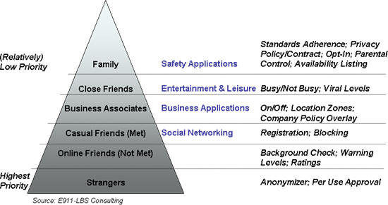