Wednesday interview: Michael Kornhauser of ALK on why satnav is going mobile
location based services
Could the next killer app for mobile phones be satellite navigation? ALK certainly hopes so. The company has been selling its CoPilot Live application for PDAs and smartphones for some time now, but in the latter case it's always been dependent on a separate GPS receiver, which connects to your phone using Bluetooth.
However, developments like GPS-enabled phones and HSDPA networks point to a bright future for mobile satnav, and other location-based services. ALK has certainly come a long way since the 1970s, when it was working with the US government computing routes from Earth to Mars.
"From the start, we've been providing consulting, services or applications that help people get from A to B," says managing director Michael Kornhauser. "Now it's happening on mobiles."
"In the mid-1990s, we took it a step further by attacing a GPS receiver to a laptop computer," says Kornhauser. "At the time, the laptop was the only entity available that had the computing power and memory to do satellite navigation. But we always had a view to ultimately reduce that in size for mobile phones."
From the early days of its CoPilot product, ALK was working closely with Microsoft on the latter's handheld platforms, initially WinCE and then Pocket PC. ALK was to launch the first mobile edition of CoPilot for the Cassiopeia PDA. From there, the company has developed its CoPilot Live product for smartphones, and according to Kornhauser is looking to extend that to more mass-market phones. He also says that CoPilot Live has been built with mobile in mind.
"A lot of navigation systems are either on-board, where all the data is stored on the system, or off-board, where you effectively dial up to a server," he says. "CoPilot Live is something we call hybrid-compliant, so it takes advantage of the tremendous computing power on these smartphones and the diving cost of smart memory, to do all the computing and map storage on-board, but goes off-board for value-added services and other elements of navigation."
How does this work? Well, in most cities, street-level map data doesn't change that much, but information like traffic conditions, weather, speed camera placement is more dynamic, so more suited to being pulled down over-the-air. So how else does a product like CoPilot change between platforms? Is it essentially the same application on mobile as it is on a laptop?
"A lot of the guts are the same, and the product has similar functionality and overall look and feel," says Kornhauser. "But the UI is tweaked fairly significantly for each device. On a tablet, you have up to a 15-inch screen, so you can have a lot more information on there. But then on a Pocket PC, and even more so on a smartphone, it's imoprtant that the information is simple to understand, concise, to the point and can be understood at a glance."
So who uses this stuff, and who picks the mobile over the tablet version and vice versa? According to Kornhauser, the laptop and tablet PC versions of CoPilot Live don't sell that well in Europe, but are popular in the US with people who own camper-vans, as well as professional truckers – who may even go for the fully-fledged FleetCenter version (left). Meanwhile, smaller businesses tend to go for the PDA version, while the smartphone edition appeals more to regular punters.
"We're seeing more and more devices with these capabilities," he says. "It's not just enterprise users who have smartphones any more. Devices like the Nokia N73 and Sony Ericsson W950 are great examples. They're powerful smartphones, yet they also have great cameraphones and video or music capabilities too."
Two big trends that could make mobile satnav more common in the next year are GPS in phones, and HSDPA networks. Nokia's announcement of the N95 yesterday is sure to be the first of many GPS-enabled handsets, which removes the need to have a Bluetooth-connected GPS receiver to use applications like CoPilot Live.
"It's an absolute killer for us," says Kornhauser. "Take a look at the satnav market to date. In Europe, the big push for PDA navigation came when it was first put into a bundle in 2004. Then when that petered off a little bit, the GPS receiver got put into the device itself, and there was another big uptake. It's about having less things to buy, less things to power, and it's cheaper, which naturally gets it out to more people. And we see the same happening in the smartphone market."Meanwhile, handsets like the N95 are also likely to work on faster HSDPA networks. Kornhauser says it's feasible for someone living in, say, Munich to have the surrounding 50 miles of data stored on their device, but when they travel somewhere else, they'll be served the additional local data directly over the air. "You can do those kind of advancements if you can get five to six megabytes of data down to the handset in a reasonable time," he says.
we also... the trucking market or any large vehicle market going for our laptop or tablet. then for a pocket pc, we see a lot of general consumer appeal, and then also enterprise deployment on pocket pcs. companies using them for signatur capture will integratre their signature capture softwate and workforce mobility software. when next job comes in, accept a job, automatically laynch the navigation. so two markets for that, and prosumers buygin connected pocket pcs, eitgher on their own or throgh mobile phone contracts\nand then for smartophone products, especially since out launch or symbian uiq and series 60, seeing a tremendous ammount of consmer appeal, they\'re in high end of consumer market, they\'re smartphones, not low cost devices. a lot of high end consumer demand for thos eproducts as nokia and sony ericssoin\nit is very exciting, we see more and more deices having the capabilities. a lot of the walkman phones have storage card slots in them, so that gets us one step further. more and more processor capabilities in there, 3G, hsdpa, all this bodes v wel for what we\'re trying to do [- provide simple but highly useful satellite navifgation to these mobile phoens, devices you have in your pocket. N73 is a freat example, symbian series 60 3rd edition, latest and greatest, yet has one of the bets cameraphones / video capabilkities on the market. that conceregance right there\nalso sony eric w950, walkman symbiabn uiq phone, again, the kind of convergence of that mass marke walkman feturwswe see bopth those things coming along fairly strong in next year and years forward. we\'ll be first the smartphones will have GPS inbuilt across board, then make its way down to more mass market phones. that of course is an sbsolute killer for us. take a ltook at satmav market to date. in euroep big push for pda naviufgation when first put into a bundle - 2004 - medion in germany created one of the first pda / gps naivifgation bnundles. then when that petered off alittle bit, then gps receiver got put into the device, another big uptake. ad then forget about the pda, we\'re juts making a big bnavufation deviuce. less things to buy, less things to power, costs get rolled in on OEM, so cheaper, which naturally gets it out to more people. becomes more versatile, use it when you\'re rocking around, not just in the car, when you\'re in a taxi! it\'s almost endless.\n",1]
);
//-->
building the gps inn.othert thing, hsdpa, the networks and capabilities on the devices. while again we expet to continue to use the functionality of on-board, in reality, copilot live doesn\'t care if map data is onboard. can add scenario where 50 miles of data around germany on my device, when i lfly into munich, i have to go somewher 100km away, i serve that additional data, v fast, ubiqitous across the board, no problems with connection. those kind of advancements, not only for the services on top of copilot, but data itself, do map datra ypdated over the air, if you can get 5-6mb of info down in a reasonable time.\nwe expect ... i think everybody acros the oard is seeing large consumer demand, large opp in european omarket for consumer navigation. those elements figureing out if they can be a piece o the puzzle. from ops perspective, but a little bit oif uncertainty, how they can make it successful for their biz, can they compete with high srtreet, able to sell a piece of IT equipment a lot better than an op can. theur angle is to buikld in these services, all you can eat data plans, special offers on monthly tariff - have traffic as additional £5 a month, or build it into your updates you get from the operatoir. building propositions aroudn the data element of copilot, and ability to serve info rthrouth their networjkj on copilot.\nbig advancesi think a lot of it will come around making the navigation system... taking it from something you\'re just using when lost or on holidayu, to something you are really usinfg very day and in various differet aspects of your life. not just when lost, but using it while you are really in every aspect of your life. evven when you\'re not lost, you can still be using the navigation system, or speed camera info which is v important. or when you\'r e not in the vehidle, you can stoll get walking directions through it, oer as a life monitor which gets you where you wanna go, info on the move that has a location tag on it. we see a lot of location based content, or route based content as we would call it. lbs space, where you are, and finding stuff around. but from ALK, not about whwreyou are, but whre you\'re going. we know where you\'re going, how you\'re gonna get you, and we can serve various bits of info alon gthat way.So where do the mobile operators fit in, if at all? Will they launch their own navigation services, or partner with people like ALK, or just keep out of the market altogether? Kornhauser seems to think the second option is most likely, with operators charging customers a set fee per month for, say, traffic information which can be overlaid onto a phone's mapping software. It does seem that there's scope for more of what he calls "value-added services" with this kind of satnav technology.
"We're taking it from something you just use when you're lost or on holiday, to something you use every day in various different aspects of your life," he says. "So you might be using the speed camera information, or getting walking directions when you're not in your car, or getting other location-based content, or route-based content as we would call it. From ALK's perspective, it's not about finding stuff around where you are, but around where you're going. We know where you're going, how we're going to get you there, so we can serve various bits of relevant information along that way."
Friday, September 29, 2006
Thursday, September 28, 2006
Tele Atlas Adds Human Element To Updating Map Data
location based services
One way Tele Atlas is expanding the way it updates geographic mapping data is by asking people to provide feedback online. By Laurie Sullivan TechWeb Sep 28, 2006 08:18 PM
Anyone who has hit a dead end or got lost on their way to a meeting after carefully printing driving directions from an online site may appreciate the difficulties in keeping track of changes to the world's roadways, toll ways and freeways.
Tele Atlas, a company that gathers raw data for use in navigation systems, and mobile and online maps, used by Google, MapQuest, Nokia and others, has expanded the way it updates geographic mapping data by asking people to provide feedback online.
When the site officially launches in October, it will allow users of Internet, personal navigation and wireless devices to report changes to roads. "We are trying to help customers report changes to the database because sometimes they're familiar changes we haven't encountered," said Kamron Barron, systems and training manager for Tele Atlas North America at Tele Atlas Inc.
The site will augment a fleet of 10 bright-orange vans equipped with cameras, servers, and computers running three software applications. Drivers cover every inch of U.S. highway digitally videoing roadways.
Analysts believe mapping data will increase in importance as more electronics rely on the information to support more emerging applications that integrate real time-and-location stamps, for example. "Mapping data is an enabling technology," said Marina Amoroso, senior analyst for U.S. wireless/mobile at Yankee Group. "There are many ways for location-based services to sit behind regular apps we use daily.
In the future, consumers could see location-based services embedded behind, cellular phone camera, instant message, and push-to-talk features on phones, Amoroso said.
At Tele Atlas, cameras capture digital images of speed limit and stop signs, number of lanes per highway, and other landmarks a driver sees on roadways. The collected video is analyzed and turned into raw data for use by government agencies, as well as public and private companies.
On the roof of each van sits a global positioning system (GPS) and four cameras. Two stereo cameras provide forward and intersecting pictures of the road to let Tele Atlas create three-dimensional digital video footage. Two fixed cameras collect data on road signs.
An inertial measurement unit and odometer sit on the van's breaking system, which records the distance traveled, accurate within 0.5 and 1 inch. The system maps every angle the vehicle turns.
services (LBS) will account for 315 million, up from 12 million this year, estimates ABI Research
Earlier this week, Nokia said Tele Atlas will provide the digital map data and dynamic location content for the Nokia N95, a new multimedia device equipped with GPS functions launched. The handset maker calls the Nokia N95 a "multimedia computer" that offers consumers multiple ways to connect to information, entertainment and people. As part of the Nokia Nseries multimedia personal computers, the Nokia N95 features built-in global positioning system (GPS), WLAN, a 5 mega-pixel camera, HSDPA and dual mode menu.
The Nokia N95's navigation features will offer free, basic mapping and routing functions to initiate local searches for more than 100 countries, more than 15 million points of interest to help consumers easily find local attractions, and optional upgrades to full navigation features to let users quickly find routing information wherever they need to go.
Tele Atlas's 2,300 employees in 30 countries map out roads in 51 countries.
Solar flares to disrupt GPS for several hours in 2011 or 2012
location based services
Ok GPS fans, we're prepping you early for what could be a moment of pretty severe inconvenience in the not so distant future. Brace yourself, because in roughly five to six years, your beloved handheld devices won't work for several hours due to solar flare activity (sound familiar?). According to new Cornell University research, solar flares negatively affect GPS devices, based on observations of stellar phenomena in September of last year. In 2011 or 2012, when the sun reaches its next solar maximum, scientists expect it to cause a 90 percent GPS signal drop for several hours. While most of us will walk around, oblivious to these space fireworks, Alessandro Cerruti (pictured on the left), a Cornell graduate student who studies solar flare effects, envisions this horrific day as a "nightmare situation," given that all planes will likely have GPS signaling by that time. However, given these harbingers of doom, Dr. Paul Kinter (pictured on the right), Cerruti's advisor, has a brilliant solution: "I think the best remedy is to be aware of the problem and operate GPS systems with the knowledge that they may fail during a solar flare." See, it's just that easy, people.
Google Local Search Has Been Integrated with Universal Address
location based services
October 1, 2006, Toronto, Canada, NAC Geographic Products Inc. announced the release of the NAC Enhanced Google Local Search - an integration of the Natural Area Coding System with Google Local Search through the Google AJAX Search API.
The NAC Enhanced Google Local Search allows users to use a Natural Area Code (NAC) in addition to using a street address to specify an area or location anywhere in the world. A NAC can represent any area or location in the world. A two-character NAC represents an area about 1000km X 700km (like a province), a four-character NAC represents an area about 33km X 23km (like a city), a six-character NAC roughly represents every square kilometer area, an eight-character NAC represents an area about 35m X 25m (like a building), and a ten-character NAC approximately represents every square meter on the earth surface. Since an eight-character or a ten-character NAC has reached the resolution of a traditional address, it is also called a Universal Address, for example, NAC: 8KDC PGFC (the Universal Address of Washington Monument). "The integration of NAC with Google Local Search produces a real worldwide local search engine that can work anywhere in the world," said Dr. Xinhang Shen, president of NAC Geographic Products Inc., "that has overcome the limitations of traditional address based specification of locations, such as inputting traditional addresses of foreign characters or specifying locations without traditional addresses." Using a Universal Address instead of a street address to specify a location on a local search can also reduce 80% of key input and eliminate the needs of address databases that frequently produce outdated matches, no matches, duplicated matches, wrong matches, etc. The NAC Enhanced Google Local Search also presents its searching results with the corresponding Universal Address attached to each found item. Therefore it can be used as a Universal Address lookup service for location sensitive businesses, with which business owners can find their Universal Addresses and then put them on their business cards and advertisements to promote their businesses. Here is another web page for people to look up the Universal Address of any street address in 24 countries. Universal Addresses can be directly measured with GPS receivers and have been widely implemented in many wireless location based services (such as mlbs.net), GPS navigating systems (such as Locamagic), etc. If you use key words: "Universal Address" and "Resort" to search Google, you will see thousands of resorts that have included their Universal Addresses as part of their addresses. Universal Addresses can be used as universal identifiers for bus stops, gates, parking meters, street lights, trees, sewage exits, fire hydrants and any other fixed objects. Using Universal Addresses as global postal codes can make all sorting machines able to sort mail from world level to final mail boxes automatically. The wide use of Universal Address enhanced GPS watches or cellphones can greatly accelerate the globalization and make accurate locations as useful as accurate time for all human activities and events. About NAC Geographic Products Inc. Incorporated in 1995 in Toronto, Canada, NAC Geographic Products Inc. is a world's leading company in geographic information technologies. In addition to the Natural Area Coding System, the company has developed many important GIS software products and provides real-time geo-services (geocoding, reverse-geocoding, mapping, driving directions, nearby business searching and traffic information) for web applications and wireless location based services. Web: www.nacgeo.com
There's a whole world out there for Google Earth
location based services
TOKYO (Reuters) - Google Inc.'s (GOOG.O: Quote, Profile, Research) Michael Jones likes to take pictures with a super high-resolution camera like those used on spy planes during the Cold War.
His fascination is not to monitor military camps but to shoot photos so detailed he can spot, from miles away, a cozy Japanese noodle shop to have lunch in.
Jones' obsession is mirrored in his work. He is the Chief Technology Officer of Google Earth, a product used by 100 million people that combines satellite images, maps and local data to display geographical information of the world.
"Seeing your home is usually the first thing people do," Jones told Reuters in an interview in Tokyo. "As we add more local data, like hotels, there's a second wave of interest from those who want to use this in useful ways, like plan trips."
Google, the world's biggest Web search engine, has launched Google Earth in different languages including Japanese, French, Italian, German and Spanish. Jones is a great fan of Japan.
"It's not just translating," said Bruno Bowden, a Google Earth engineer who spent the past year preparing the Japanese-language product which was launched this week.
"It takes great effort to license all the local data and figure out how people might want to view it," Bowden explained.
Jones said Google is gathering country data to offer more localized editions. He also said the amount of data updated to the Google Earth database is rising. Continued...
Industry Insiders Unhappy with Operators Cut of Mobile Transactions
location based services
Valista has released the results of research, carried out at this year's Mobile Content World Conference in London which quizzed over a hundred show attendees, and revealed that when it comes to mobile content, network operators are taking too large a share of the revenue.
Mobile Content World is a show attended by content owners, handset vendors, mobile operators and technology providers. Valista asked delegates for their views on the future of the mobile content market in the next three to five years.
Over half of respondents correctly answered that mobile operators currently take 40-50% of mobile content transactions, however, less than 6% believe this will be the case in three years time. In fact almost two-thirds, 65%, of those questioned believe that in three years' time, mobile operators should cut their share by at least half - to less than 20%, with 18% of respondents believing that they should take only 5%.
What is clear is that in order to safeguard revenues, the industry needs to drive the uptake of mobile content through creative and flexible pricing, content bundling and promotions and cleverly targeted content. More than 28% of delegates surveyed believe that targeting content by demographic groups and communities will be the most likely way to increase content purchasing, closely followed by flexible pricing (27%) and improved mobile search (20%).
According to Arlene Adams, Vice President at Valista "Currently, operators take the greatest share of mobile content revenue, but the distribution of power could shift - particularly when the major media moguls secure their foothold in the marketplace. Consolidation and the entrance of major consumer brands will shape the future value chain, and operators need to balance recouping revenues with the desire to maximise their share in the long run. In this regard, operators need to look at more innovative merchandizing and marketing tools to encourage their consumers to buy more. In addition, a payments model which lowers or eliminates revenue leakage and allows end-to-end traceability for transactions and the parties involved, will allow operators to look at lowering their fees while encouraging growth in the content market."
Good news for the industry came in the finding that mobile TV and Video downloads will be the most popular forms of content over the next few years, an opinion that mirrors recent analyst predictions. Broadcasting rich content will see a move from lower value payments (micro-payments) to higher value transactions (macro-payments). In this regard, operators need to protect their brand and look at personalized and compelling content to grow Average Revenue Per User (ARPU) and drive off competition from more traditional payment schemes. Less positive for operators was the finding that only 15% of content purchased will be part of an ongoing subscription model.
What may make uncomfortable reading is the fact that, according to attendees, mobile operators will not see content purchases making up for falling revenues. More than half of those who contributed (58%) believe that in three years' time, less than 25% of total operator revenue will come from mobile content and 15% believe that it might drop as low as 10%. This figure is interesting given that mobile content already accounts for 20% of an operator's revenue, and evidently figures working in the industry are unaware that this is the case. iGillott Research predicts that mobile content will account for 40% of operators' revenue by 2009.
Despite the variations in the predictions above, those questioned in the Valista poll were in agreement on the future of mobile payments, with more than 65% believing that the current system of paying for mobile content via Premium SMS will, in the next few years, give way to more flexible and robust payment methods such as paying via the monthly bill (direct-to-bill charging).
OSI Geospatial Awarded U.S. Department of Defense Contract Valued at US$3.8 Million
location based services
VANCOUVER, BRITISH COLUMBIA-- Sept. 27, 2006 - OSI Geospatial Inc. (TSX:OSI)(OTCBB:OSIIF) announced today that its U.S. systems operations has been awarded a three year contract totaling approximately US$3.8 million by the U.S. Defense Threat Reduction Agency (DTRA). Under the contract terms, OSI will develop a Global Positioning System (GPS) Denied Navigation and Mapping System for the DTRA."OSI is a world leader in the development and production of Navigation and Mapping systems for international military and commercial applications. This contract will enable OSI to evolve our leading edge technology into the Hand-Held/Wearable Personal Navigation Systems market," said Ken Kirkpatrick, President and CEO of OSI Geospatial. "We are very pleased to be working with the Defense Threat Reduction Agency, a new customer for us. Along with expanding our customer base, this contract provides for further diversification of our products, supporting two of the strategic goals we established for this year."About OSI GeospatialOSI Geospatial Inc. delivers advanced systems and software to address the growing need for enhanced situational awareness in command, control, communications, and intelligence applications. By providing essential tactical and geospatial information, the company's systems and software help decision-makers know the precise location of mission operations across all military forces while integrating information with allies. OSI Geospatial systems are in use by military, government, and commercial customers around the world. The company is publicly traded on the Toronto Stock Exchange (OSI) and the Over the Counter Bulletin Board (OSIIF). For additional information please visit www.osigeospatial.com.
Sandbridge Readies Commercial Release of Third-Generation Mobile Handset Chip
location based services
WHITE PLAINS, N.Y., Sept. 27 -- Sandbridge Technologies is sampling its SB3011 chip that implements a complete third-generation (3G) mobile handset capable of operating virtually any radio protocol required for a common (universal) multi-mode, multi-function mobile platform and significantly reducing the time to market and total cost of ownership for OEMs and carriers. The SB3011 not only reduces hardware requirements and integration complexity for devices, but enables profoundly enhanced software OTA and after sales feature upgradeability.Sandbridge's latest breakthrough in the quest for a universally accessible handheld platform is the delivery of power consumption levels on par with those of traditional application-specific integrated ICs (ASICs), thus eliminating the last hurdle for cost-effective deployment."Specifically, the SB3011 has met all the target power consumption specifications required by our customers, allowing WCDMA implementation at 384 kilobits per second below 180 milli-watts," said Guenter Weinberger, President and CEO of Sandbridge.The SB3011 baseband processor's unique architectural innovations deliver completely scalable DSP performance for virtually any radio protocol used in various regions around the world, such as GPRS, EDGE, WCDMA, CDMA2000, EV-DO, Wi-Fi, DVB-H and GPS -- as well as multimedia formats such as MPEG-4 H.264, MP-3, WMA and more. Sandbridge is also developing High-speed Downlink Packet Access (HSDPA) and WiMax solutions as an upgrade to the platform and will evolve its platform to provide manufacturers timely solutions for the evolving standards of the global wireless marketplace.The SB3011 is currently being sampled to select top-tier manufacturing customers who are developing next generation handsets independent from fixed-function ASIC's."A low-cost, low-power common platform based on standard hardware and software has been widely regarded the 'holy grail' of wireless communications technology, because it creates new economies of scale for OEMs and carriers," said Weinberger.Sandbridge's unique technology delivers the lowest cost platform for the rapidly growing 3/3.5G-WiFi-WiMax-Digital video broadcast (DVB) market by enabling 100% flexibility for die size re-use. This flexibility is critical for reconfigurability, enabling rapid implementation of new features and functions. Likewise, it enables extensive over-the-air upgrades and software application downloads, closing the time-to-market gap for applications developed for computers to migrate to wireless platforms. Furthermore, the SB3011 provides third-party applications developers a common platform based around the C programming language, long a standard within the development community. As part of a common platform, this will further expedite development and rapid distribution of new features and functions.The advent of the SB3011 signifies the beginning of a new wireless era marked by common, stable platforms for consumer use and application development. For OEMs and carriers, this can mean significant cost reductions. For consumers, it augurs truly convergent devices with powerful new functions and features without the need to carry multiple devices with services requiring unique protocols that previously could only be implemented with custom hardware.The software-based design of the SB3011 paves the way for ultra-mobile- computers with virtually unlimited communications protocols and multimedia applications.About Sandbridge Technologies (www.sandbridgetech.com):Located in White Plains, NY, Sandbridge Technologies is a fabless semiconductor company that is transforming and revitalizing the global wireless handset market by enabling freedom from fixed functionality baseband solutions-providing to better features-to-cost ratio, and accelerating the development of next generation wireless devices. Founded in 2001 by veterans of IBM, Lucent and Cadence, Sandbridge has developed a radical new multi-thread DSP architecture with the capacity to perform flexible (SDR) baseband processing and advanced multimedia operations without compromising battery consumption. Sandbridge Technologies Inc. is a venture funded company with investments by Bessemer Venture Partners, Atlas Venture and Columbia Capital and other strategic investors.
Bones in Motion Brew Application Enables Powerful Fitness Monitoring and Music Integration
location based services
AUSTIN, Texas, Sept. 27 /PRNewswire/ -- Bones in Motion today announced the launch of its BiM Active application developed for QUALCOMM's BREW® solution, which will extend the availability of compelling location-based services (LBS) to more wireless subscribers across the country. The company today also detailed its partnership with Rodale, the publishers of Runner's World and the leading authority on fitness. The BiM Active BREW application allows users to leverage all they love about their mobile phones -- communications, safety, productivity -- with the added feature of a fitness tracker and music capabilities. The vision of one true integrated device is now a reality.
BiM Active enables runners, cyclists and walkers to wirelessly capture and monitor their activity in real-time on GPS-enabled mobile devices. Users with BREW phones that have a music player can also play music while recording their fitness information. When the activity is completed, the exercise information is uploaded to a personal online journal or Web portal on http://www.bimactive.com. There, users can chart their personal progress and share information such as routes with ratings and reviews. For more information about BiM Active, please visit http://bimactive.com.
BiM Active was created by Bones in Motion, leveraging the advanced capabilities of QUALCOMM's gpsOne(TM), QPoint(TM), and BREW solutions. gpsOne assisted-GPS technology is integrated into most QUALCOMM chipsets to enable slimmer handsets with greater power-efficiency. The BREW platform enables BiM Active to run simultaneously with a music player allowing for true integration of a fitness tracker tool and music on a mobile phone.
"Whether you are training for a triathlon or walking to get in shape, BiM Active leverages the BREW solution to create a motivational tool that provides instant audible feedback during the activity and support and information online," said Andrew Graham, CEO of Bones in Motion. "Our vision is to create a truly interactive experience and virtual community that helps people achieve their fitness goals, and QUALCOMM's range of technology offerings provide an easy path to quickly support the popular mobile phones our customers are asking for."
"BREW publishers and developers continue to create compelling content that is truly useful for the mobile consumer's lifestyle and the BiM application is a perfect example of such innovation," said Sachin Deshpande, head of Developer Relations for QUALCOMM Internet Services. "Bones in Motion's new BREW application is a perfect blend of LBS capabilities, fitness monitoring and music player and exemplifies what is possible in mobile content today."
The BREW solution drives the discovery and delivery of data services. BREW subscribers benefit from several offerings, which include: uiOne(TM) for rich, integrated and dynamic user experiences with fast access to high revenue services on wireless devices; deliveryOne(TM) for differentiated and tightly integrated, operator managed support and delivery of advanced wireless data content and services; and marketOne(TM) for a quick-to-market, hosted, scalable content delivery service that includes media titles, flexible management and monetization, content provider settlement and business intelligence services. QUALCOMM offers this comprehensive set of BREW offerings to meet the needs of companies delivering mobile products and services around the world.
About Bones in Motion
Bones in Motion (BiM) provides award winning, subscription-based mobile lifestyle phone applications and services. For the active consumer, BiM is a catalyst for extending the mobile phone to become a motivational companion for fun, fitness, sports, diet, and personal safety. For more information on Bones in Motion, please visit http://www.bonesinmotion.com.
QUALCOMM and BREW are registered trademarks of QUALCOMM Incorporated. gpsOne, QPoint, uiOne, deliveryOne and marketOne are trademarks of QUALCOMM Incorporated. All other trademarks are the property of their respective owners.
Media Contacts:
Lauren Sell
Porter Novelli for Bones in Motion
512-241-2246
lauren.sell@porternovelli.com
GPS-Enabled Location-Based Services (LBS) Subscribers Will Total 315 Million in Five Years
location based services
In 2011, the total population of GPS-enabled location-based services (LBS) subscribers will reach 315 million, up from 12 million in 2006, according to a new study from ABI Research. Put another way, that represents a rise from less than 0.5% of total wireless subscribers today to more than 9% worldwide at the end of the study's 5-year forecast period."Regions of greatest growth will be North America and Western Europe," says senior analyst Ken Hyers. "The Asia-Pacific region will have strong growth as well, but it will vary by market. Leaders South Korea and Japan will continue to be engines of LBS growth, but North America, which has seen strong business use for several years, is expected to see significant consumer uptake in 2007 and beyond."The LBS market took off first in South Korea and Japan, driven by personal navigation and some family- and people-finder services. In the United States, Nextel and Sprint initially drove LBS adoption with a focus on fleet applications. In 2006 Verizon Wireless also entered the market and has three applications available currently, with as many as five more planned for rollout over the coming months. Market growth in Western Europe has been limited by the fact that very few GSM/WCDMA handsets have GPS, but ABI Research expects that beginning in 2007 and increasing in 2008, many more WCDMA 3G phones will contain GPS chipsets, allowing operators to offer LBS. Anticipating this, at least one additional operator will be offering GPS-enabled LBS in Europe starting late in 2006. ABI Research expects that in 2007 at least four major operators in Western Europe will follow suit."GPS services will drive the adoption of UMTS 3G handsets," says Hyers. "3G growth has been limited by customers' low uptake of many 3G services, making it uneconomical for operators to subsidize these handsets heavily. GPS-enabled LBS is expected to lead subscribers to use more 3G data services, and thereby to drive overall 3G handset sales."ABI Research's new study, Location-Based Services, examines the market opportunities for LBS from a handset-based perspective, focusing on location technologies, operator deployment strategies, and GPS-enabled handset evolution. Major forecasts in this report include GPS-enabled LBS subscribers by major world markets and by major application class, and GPS-enabled handset shipments by major world regions. It forms part of two ABI Research Services: Mobile Operators and Mobile Devices.Founded in 1990 and headquartered in New York, ABI Research maintains global operations supporting annual research programs, intelligence services and market reports in broadband and multimedia, RFID and M2M, wireless connectivity, mobile wireless, transportation and emerging technologies. For information visit www.abiresearch.com, or call +1.516.624.2500.
Beth Schechner (pr@abiresearch.com)Phone: 516-624-2542
Studies point to big LBS uptake
location based services
NEW YORK—Two research firms say the future looks bright for location-based services running on Global Positioning System technology.
ABI Research’s latest study on the subject suggests that subscribers of GPS-enabled LBS services will reach 315 million by 2011, up from 12 million this year. The firm points out that the increase represents a rise from less than 0.5 percent wireless subscribers today to more than 9 percent within 5 years
Ken Hyers, senior analyst at ABI, explained that North America and Western Europe will see the greatest growth, while countries in the Asia-Pacific region will see varying growth rates. “Leaders South Korea and Japan will continue to be engines of LBS growth, but North America, which has seen strong business use for several years, is expected to see significant consumer uptake in 2007 and beyond,” said Hyers.
ABI said the LBS market took off first in South Korea and Japan, driven by personal navigation and some family- and people-finder services. In the United States, Nextel Communications Inc. and Sprint Corp. initially drove LBS adoption with a focus on fleet applications, and this year Verizon Wireless entered the market. Verizon Wireless has three applications available, and as many as five more planned for rollout during the coming months.
However, market growth in Western Europe has been limited by the fact that very few GSM/W-CDMA handsets have GPS, but ABI Research expects that beginning next year and increasing in 2008, many more W-CDMA 3G phones will contain GPS chipsets, allowing operators to offer LBS. Anticipating this, ABI said at least one additional operator will be offering GPS-enabled LBS in Europe starting late this year, and ABI Research expects that in 2007, at least four major operators in the region will follow suit.
What’s more, Hyers predicts that GPS services will drive the adoption of UMTS 3G handsets. “3G growth has been limited by customers’ low uptake of many 3G services, making it uneconomical for operators to subsidize these handsets heavily. GPS-enabled LBS is expected to lead subscribers to use more 3G data services, and thereby to drive overall 3G handset sales,” Hyers said.
A new study from IMS Research suggests there will be a significant increase in the number of GPS-enabled handsets shipped in 2008, coupled with an increase in A-GPS network rollouts worldwide.
IMS Research forecasts differing degrees of growth for each of the major cellular technologies, each one having its own market drivers and inhibitors. The firm said overall growth is reflected by sales of GPS-capable phones, which is forecast to have a CAGR of just under 40 percent during the next four years.
Patrick Connolly, GPS analyst at IMS Research, noted that, in order to reduce costs, the move toward single-chip design will accelerate next year. The firm said it expects that there will be an increased effort to get power consumption and size down to meet the constraints of increasingly over-burdened handsets, and that these solutions initially will target laptops, cameras and portable GPS units rather than cellular handsets.
The overall effect, according to IMS Research, is that GPS solutions are becoming more appealing to handset manufacturers and network operators. Already a number of handset operators are planning to release GPS-enabled handsets targeting the mass market, rather than previous niche-market solutions. This is partly driven by imminent A-GPS announcements from network operators, but also the potential to offer autonomous GPS and server-based location services via application service providers, the firm said. As GPS proliferates in the cellular market, there is huge potential for increased revenues for network operators offering a broad range of GPS-based location services.
However, Connolly warned, “Location services have been around for years, via network-based triangulation, but have been poorly exposed and marketed to end users. If GPS-enabled handsets and location services are to take off beyond mandated regions, there needs to be a dedicated push to make end users aware of the exact services that are available to them, coupled with competitive pricing models.”
Furthermore, IMS Research said that an end-user survey carried out as part of its report clearly indicated that consumers make a direct correlation between cellular GPS and satellite –navigation, and were unaware of the full potential of cellular location services. To distinguish these services from other GPS solutions, “service providers need to offer more than just sat-nav solutions and highlight all the other benefits of having GPS in your phone,” the study said.
go2 and Enpocket Form Strategic Mobile Advertising Alliance
location based services
Companies partner to provide advanced campaign mechanics that drive more value for mobile advertisers
Irvine, Calif. – go2 Directory Systems (www.go2.com), a leading provider of local search and movie guide information over mobile devices in the U.S., and Enpocket, the leader in intelligent mobile marketingTM, today announced a strategic alliance for designing and integrating sophisticated campaign mechanics into mobile advertising and marketing programs. go2 and Enpocket will work together to jointly design, develop, operate and market enhanced mobile marketing solutions with a focus around go2’s expertise in location-based services and Enpocket’s deep experience in mobile advertising. “Having delivered close to one billion mobile page views of local directory information since our inception in 1999, go2 has learned that its users want quick and easy access to local information when they’re on the go,” said Lee Hancock, CEO of go2. “go2’s goal is to use the mobile medium to create solutions that are valuable and appreciated by users. Enpocket’s mobile marketing platform is unique in its ability to integrate and scale up our mobile advertising and marketing programs, including mobile internet, messaging and advanced data targeting. A robust mobile marketing solution enables go2 to drive advertising revenues and provide a means for advertisers and wireless consumers to connect.”The strategic alliance will enable go2 to offer its brand advertisers best-of-class integrated mobile marketing campaigns, including:
Click-for-coupon advertising
Click to locate retail outlets
Mobile internet-based micro-payments
Affiliate partner text message programs
Advanced end-to-end campaign reporting and analytics
“Marketing on the mobile web has become very attractive to advertisers because of the ability to target consumers more precisely than ads on television, online or in print,” said Enpocket CEO Mike Baker. “By combining go2’s location-based search and directory offerings with Enpocket’s marketing platform, we’re creating campaigns that work for brands and deliver relevant information to consumers on-the-go.”About go2® go2 owns and operates numerous location, event and category-specific online and mobile websites as integral components of the go2 Mobile Content Network, including go2 Movies®, go2 Dining, go2 Travel and go2UCLA. go2 websites have industry-leading distribution through one-of-a-kind multi-category placements on the wireless Web menus of most major U.S. carriers, providing mobile users with easy access to information on-the-go, including driving directions, horoscopes, magazine articles, movie times, sports trivia, travel information, weather and more. All go2 mobile content sites are fully integrated with any GPS-like automatic location services provided by wireless carriers, and feature one-touch calling and turn-by-turn directions together with detailed information on thousands of U.S. businesses. go2 Advertisers include ABC, American Express, AOL, Delta, ExxonMobil, Holiday Inn, MasterCard, Nokia, SBC, Shell, Sony and Visa. Headquartered in Irvine, Calif., go2 is a privately held company. go2 holds or licenses several U.S. patents for location-based, local search and directory services on mobile devices. For more information, visit www.go2.com. go2®, go2 Movies® and go2 mGuide™ are registered and unregistered trademarks of UDS Directory Corp., dba go2 Directory Systems.About EnpocketEnpocket, the Intelligent Mobile Marketing™ company, enables organizations to foster and maintain valuable relationships with mobile consumers. Enpocket technology powers the mobile marketing efforts of operators and media companies around the world, and Enpocket services help leading brands effectively market in the mobile channel. Customers include:Mobile Carriers: Cingular, Sprint, Alltel, Vodafone, BT, Orange, Airtel, Virgin Media Companies: News Corp, CNBC, A&E, Clear Channel, Chrysalis, Internet Broadcast Systems, Sony Pictures, TNT, Trinity Mirror Brands: McDonalds, Dunkin Donuts, Pepsi, Subway, Motorola, Samsung, Panasonic, BenQ-Siemens, Sprite and GM. Enpocket has offices in Boston, London, Singapore, and Mumbai. To learn more see www.enpocket.com.
Australia Google Maps Mashup Roundup!
location based services
Go Do Australia" Tourism Mashup - Godo (.com.au) is a fantastic Australian travel and tourism site that lets you browse a wide range of activities and make online bookings. This is great for the budget traveler that is planning as he/she goes or for Australian residents looking for weekend or holiday activities. Godo has integrated Google Maps into the browsing and booking experience by plotting the activities on a Google Map. You reach the Google Map after choosing the state from the main page. [via]Colour Sydney Street Photographs (Click on: "click here to dive straight in!") - Andrew Nemeth has taken some awesome photos around the Sydney area and geocoded them to their location on Google Maps. This map (follow the instructions above to find the map) will show you all the photos. Click on the picture in the info window to view them in full size. There are some fantastic shots of Sydney life here. The mapping of the photos allows you to visualize where each picture is taking place. Awesome Sydney Panoramic Views (Click on: "click here to dive straight in!") - Andrew Nemeth has also been busy taking panoramic movies as well. This map shows all VR panoramic views and their mapped location in the Sydney area. Included in this map of VR-views (follow the instructions above to find the map) are panoramics taken on the set of the Superman Returns movie! The Sydney Opera House is the best in my opinion! :)New Google Maps Real Estate Mashups:Realestate (.com.au) [via]MyPackage (.com.au) [via]More Australian Real Estate MashupsSydney Morning Herald reports on nude sunbather found on Google Maps/Earth - I caught a great article from Online Technology Editor Stephen Hutcheon of the Sydney Morning Herald this past week that covers the infamous nude sunbather that has been discovered on Google Maps/Earth (Note: the image is better on Earth than Maps). The ball got rolling with this post from GoogleSightseeing which was then severely digged. Stephen brings proper journalism principals to the human interest story in this fantastic article that brings us even more information about the imagery. He's even created a short clip that is available on YouTube that shows you where the person is located. Watch it here.. EarthWallpapers - More on this in a later post, but Lucas Ng from Domain.com.au tells me a few Sydney guys made this one..RememberTheMilk - Web 2.0 task manager site recently integrated with Google Maps. This site is produced in Australia.Check out my last Australian Google Maps Mashup Roundup!
Wednesday, September 27, 2006
GoDo
location based services
GoDo also allows you to browse activities at your leisure, searching by date, price, region and town. And if knowing what's available in relation to your home or accommodation is important, you can pinpoint your exact location using our Google™ maps facility and it will display activities available within a set radius.
Nokia N95
at last a phone that will put -- location based services -- front and center
Nokia have announced the Nokia N95, featuring an innovative double slide design with multimedia controls and a keypad on opposite end of the phones. Read on for full details, pictures and the full press release.
Summary: The N95 is Nokia's first HSDPA (3.5G) device, but also boasts Wi-Fi, WCDMA, quad-band GSM, Bluetooth (including A2DP), IrDA and USB 2.0 connectivity (via mini USB connector). Other hardware features include a 5 megapixel camera, a built in GPS, TV-Out, 3.5mm audio jack, FM Radio, a MicroSD memory card slot and 150MB of internal memory.
In the hand the most impressive aspect of the device, given its feature set, is its size. At 99mm x 20mm x 53mm (90cc), the N93 packs an impressively amount into a small space. Nokia have managed to add two major technologies to the Nseries line (GPS and HSDPA) while significantly reducing the volume of the device. In length and width dimensions it is larger that the other Nseries slider - the N80, but it is considerably thinner.
HSPDA is the next generationin cellular connectivity. The N95 is a category 6 HSPDA device which means it is up to 10 times faster that WCDMA (3G). Clearly HSDPA support is required at a network level, but many networks have already begun their testing or roll out periods. The faster connection speeds make downloading media (such as podcasts via the in built Podcast application) more palatable and should also improve latency/round trip times. Wi-Fi, WCDMA (3G) connectivity, together with quad band GSM and EDGE are also supported. Bluetooth 2.0, IrDA and USB make up the local connectivity options.
The 5.0 megapixel camera uses Carl Zeiss Optics with autofocus and digital zoom with a dedicated 2 stage capture button on the side of the phone. Video capture at near DVD quality is also supported. On the side of the device there are several buttons dedicated to camera usage. This allows the device to be held in a similar way to a traditional camera with the screen, in landscape mode, used as the view finder and the shutter button on bottom right hand side of the device (top right when phone is held horizontally). On the rear of the device, next to the camera is the slide switch, which is used to open the lens aperture and activate camera mode. Although it is difficult to judge the image quality at this stage the evidence we saw suggest that the N95 will be on of the most capable camera phones available.
A GPS is integrated into the device with anticipated accuracy of around 10m (satellite signal permitting). The devices will ship with an application called Maps which has global overview maps built in. More detailed maps (with coverage over more than 100 different countries available) can be downloaded for free from an online server. The detail available varies from country to country, but in many cases it is available down to street level. A point of interest (POI) database is also included. All the maps are available for free, as is basic route planning, but navigation functionality (with voice and on screen prompts) will be available as a pay-for add on. City Guides will also be available for purchase and other services are likely to be made available in the future. The mapping software and services is likely to based on technology from gate5, a company which Nokia recently announced it was acquiring.
Music playback is also a major focus of the device. The dedicated multimedia keys on the top flip of the device are primarily designed for music playback (although can also be used in other multimedia contexts). Wireless stereo sound output (via the A2DP Bluetooth profile) is also supported, and stereo audio output is also supported by the TV output feature and the on board stereo speakers. The music formats supported include MP3, AAC, AAC+ and WMA. Video playback on the QVGA screen is excellent and supported video formats include 3GP, Real Video and MP4 with support for the latest AVC codec.
The multimedia key now leads to a revamped application and multimedia shorcut view which now supports both a greater number of shortcuts (applications, multimedia files and bookmarks) and more flexible personalisation. As a result it is now a more generic shortcut key mechansim and offers an alternative to the standard application launcher.
The N95 uses S60 3rd Edition Feature Pack 1 (Symbian 9.2) and as such includes version 2.0 of the open source Nokia web browser (supporting WML, XHTML and HTML in one browser), Flash Lite 2.0, FOTA (firmware over the air updates) and more.
The N95 uses the same small power port as other S60 3rd Edition devices, but the in-box charger is considerably smaller than the existing models (up to 60% smaller). The N95 has a 950 mAh battery, it is likely that the N95 will require a daily charge with moderate to heavy use, although 3-6 days may be possible with lighter use (dependent on network strength, type and other factors).
The N95 will be available in Q1 2007 and the approximate unsubsidised price is €550. Initially it will be available in the EMEA market. It will not be officially available in the US although gray imports are very likely.
Click images for high resolution original images.
Official press release:
It's what computers have become - the new Nokia N95 September 26, 2006
Nokia Open Studio 2006, New York, US - Nokia today introduced the Nokia N95, an all-in-one multimedia computer with a pioneering 2-way slide concept, integrated GPS functionality, a 5 megapixel camera and support for high-speed mobile networks, making it easier to watch and record videos, listen to songs, take high-quality photos, browse the internet, or catch up on email while on the move.
"The Nokia N95 brings a range of multimedia ingredients together, such as a fantastic display, outstanding photo and video capability and high-speed connectivity, making it the ultimate multimedia computer," said Anssi Vanjoki, Executive Vice President, Multimedia, Nokia. "This single device - which fits easily in your pocket - can replace stand-alone devices that you no longer need, whether it's your music player, your digital camera, PDA or navigation device. Most importantly, the Nokia N95 is with you and connected when you want to use it."
The innovative 2-way slide concept makes it easy to switch between different modes, going from reading maps to watching a video with a simple slide. A numeric keypad slides out from one end of the device while dedicated media keys slide out from the opposite direction, converting the display into full screen landscape mode. With powerful 3D graphics, the Nokia N95 has a stunning user interface that makes it intuitive to find the features and services you want.
With its integrated GPS at your fingertips, finding your way just got easier. The Maps application includes maps for more than 100 countries, enabling users to explore the world, find specific routes or locate services such as restaurants and hotels and covering more than 15 million points of interest. You can also purchase additional features, such as city guides and voice guided navigation.
With the Carl Zeiss optics on the 5 megapixel camera, you can capture print quality photos and DVD-like quality video clips. Photos and video clips can be enjoyed on a compatible television thanks to the device's TV out feature and support for Universal Plug and Play (UPnP) technology.
Designed for High Speed Downlink Packet Access (HSDPA) networks and with support for WLAN, EDGE and WCDMA networks, the Nokia N95 provides excellent coverage and speeds wherever you may be. In HSDPA networks, browsing the internet, reading email, streaming video and downloading large files can be carried out up to 10 times faster than with 3G.
The Nokia N95 also offers a first class entertainment experience with the combination of a large 2.6" QVGA 16 million color display, impressive 3D graphics, built-in stereo speakers offering a 3D stereo effect, standard 3.5 mm audio jack, support for compatible microSD cards and mini USB for convenient data transfer. Browsing the internet on the Nokia N95 is a pleasure using the Nokia Web Browser with Mini Map, with new features such as a floating toolbar, password manager and auto complete, as well as web feeds with support for Atom and auto update.
The Nokia N95 is based on the world's leading S60 software on Symbian OS, enabling you to personalize your device from a wide choice of compatible applications that can be downloaded to the Nokia N95, including games, navigation, entertainment, productivity and creativity. The Nokia N95 comes out of the box ready to create, connect, consume and interact with some of the internet's most popular services. Use Yahoo! Search to search for and find most anything on the web, scroll though a book with Amazon's MobiPocket Reader or snap a photo and send it directly to your Flickr site.
The Nokia N95 is expected to start shipping in volumes during the first quarter of 2007 at an estimated unsubsidized retail price of 550 euros.
Categories: HardwarePlatforms: S60 3rd Edition
knowledgeSmarts
location based services
GeoSpatial Knowledge Base System
knowledgeSmarts is based on Image Matters’ pioneering, award-winning research in geospatial semantics. It is a knowledge management system that provides data storage, knowledge inference, and information retrieval services for intelligent geospatial applications. knowledgeSmarts uses ontology languages to explicitly represent semantic information and uses W3C Semantic Web standards as the interlingua for knowledge sharing. Encoded geospatial knowledge can be exploited at runtime by knowledgeSmarts reasoning services. knowledgeSmarts integrates with leading geospatial data store solutions.
For more information about knowledgeSmarts and other Image Matters products and services email info@imagemattersllc.com.
dotMobi Registration Open to Public
location based services
By James Alan MillerSeptember 27, 2006
Click to ViewThe promise of dotMobi, introduced back in May, is to deliver better more streamlined Internet content to mobile devices through optimization. Now that a Sunrise Registration period for owners of intellectual property is over, the mobile Top Level Domain Ltd (mTLD) in charge of registration for the new domain name has opened up its doors to the general public.
13,000 trademark companies joined during the Sunrise period. It is said that 25,000 were originally expected.
mTLD anticipates signing up over 200,000 dotMobi sites within its first year. Yesterday began what is being labeled the Land Rush period, a (well) rush of over 75,000 registrants registered .mobi domains. During this time, applicants will pay more than when the Standard General Registration starts on October 11th. In general, a .mobi address should go for about $25 for a two-years.
.mobi is supposed to signify a site has been formatted for cell phones and other mobile devices. To ensure constancy and make its goal of a more mobile Web a reality, dotMobi has established best practices, style sheets, standards and tools. The dotMobi Switch On! Guide for Web Development contains rules and is based on open standard to ensures that sites can be viewed and navigated by any wireless devices.
"In the past, using the Internet on a mobile device presented huge obstacles for the consumer," said Neil Edwards, CEO of dotMobi. "We're creating a link between mobile operators, Internet content providers and the millions of mobile users seeking a consistent, reliable and enjoyable Internet experience."
Pushed by the likes of Microsoft, Nokia, Vodafone and Samsung Electronics, .mobi won approval from the Internet Corporation for Assigned Names and Numbers (ICANN) in July 2005. Nokia first proposed a domain extension for mobile devices back in 2000, but ICANN rejected it because of the lack of technical details in the application. Nokia persevered, however, garnering industry support, before re-submitting it as .mobi in March 2004.
.mobi has met with some criticism, including from the World Wide Web Consortium (W3C) and Sir Tim Berners-Lee, the group's director and Web inventor. They would prefer a system where a single site (.com) is built and optimized pages for mobile devices are sent only when a cell phone, for example, accesses that site. Whereas .mobi works by creating two Internets in their opinion: one for mobile devices (.mobi) and one for desktops (.com).
The Jelbert GeoTagger
location based services
STOP PRESS! - due to popular demand, we will shortly be offering a complete package including the GeoTagger, the Garmin and RoboGEO together. Please email for details.
The Jelbert GeoTagger is a compact device, smaller than most flash guns, that uniquely connects to the camera flash shoe and follows the direction of the camera lens. Once fitted, it will record the precise location AND direction of every photograph you take.Share your geo-tagged images on-line in photo communities or manage your photo library more efficiently using mapping. See the demo page for examples.
The Jelbert GeoTagger is more advanced than other geo-tagging devices on the market. Other solutions estimate the location of the photograph from a recorded GPS track and guess at the direction of the photograph using GPS track data. This frequently leads to inaccuracies that can reduce the value of your location meta-data and photograph. It also limits the ability to cross-reference the picture with mapping databases.
Only The Jelbert GeoTagger records specific location information each time a picture is taken. It guarantees accurate position and direction data every time.
When each photograph is taken, the Jelbert GeoTagger receives a signal via the flash shoe that tells it to capture the current location and direction data from the GPS receiver. It stores it on the built-in SD FLASH memory card and records data relating to:
· Latitude and Longitude· Magnetic compass direction· Time and date
At the end of the photo session, the location information is merged with the photographs. This must be done using 3rd party software such as RoboGEO (purchased separately). The data is merged automatically by referencing the date and time stamp on each photograph with the date and time stamp of each record on the SD card.
The Jelbert GeoTagger has been built for all photographers. It works with most camera makes with a flash shoe, including digital and film SLR cameras. If the camera does not have a flash shoe, the manual trigger button can be used instead so compact and pro-sumer cameras can also be supported.Film based SLR cameras are supported providing they have a time and date stamping facility. Cross referencing is then done manually with the printed photos.
The Jelbert GeoTagger has a mount for the popular Garmin Geko 301 GPS receiver which must be fitted in order to operate (purchased separately). This popular GPS unit can provide accuracy to around 1.6M and works best when outside with a clear view of the sky.
Photographers like to be creative and take pictures while holding the camera at all angles. Tilting can stop the GPS receiver and compass from working properly so the Jelbert GeoTagger has a unique innovation called GeoLock ®. When activated, the photographer can take pictures at any angle of tilt and still capture accurate location and direction information.
Click on the picture on the right to see a larger image.
Move over, Rand McNally: Google Earth is becoming the standard tool for organizing geographical information.
By Wade Roush
Almost any geospatial data can now be easily imported into Google Earth. This image shows the 3-D model of a building, developed using software from Bentley Systems, and placed within Google Earth. (Courtesy of Bentley Systems)
Thanks largely to Google Earth, released by Google in 2005, finding information linked to geographical locations is becoming far easier. Now, earlier this month, Google unveiled new layers for Google Earth: collections of practical and educational resources related to specific places on the planet.
Icons linking to this mass of information--which is being provided by organizations such as the United Nations, the U.S. National Park Service, National Geographic, and Turn Here, a publisher of city guides--appear atop the Google Earth landscape with the click of a mouse.
Although details such as buildings, national boundaries, and road networks have long been a part of Google Earth, this new "featured content" material represents the website's first official attempt to build what might be described as a geographically indexed world encyclopedia.
In fact, with more than 100 million copies of Google Earth downloaded between June 2005 and March 2006 (and an undisclosed number since then), Google stands to dominate the online mapping industry.
"People don't know how much good geocoded information is out there. Google is trying to correct that," says Frank Taylor, a North Carolina-based entrepreneur who publishes Google Earth Blog, an unofficial guide to the program's features.
On its surface, so to speak, Google Earth is simply a collection of zoomable aerial and satellite photos carpeting a 3-D model of the Earth. But the software's real significance is much broader. Almost any type of information can be uploaded to the Web and then downloaded directly into Google Earth, as long as it is encoded in Google's open file format, KML, where it's visible as a new "layer," or annotation, superimposed on the satellite data. Today, thousands of individuals and companies are using KML to create and share their geotagged documents, turning Google Earth into a giant source for location-specific data.
With the new featured content, Google is calling attention to some of this information--from trail maps, professional nature photography, QuickTime movies, and links to magazine articles, to images from space documenting environmental degradation in various regions of the world over time. For example, the United Nations Environmental Program has provided 35 years of Landsat photos that can be overlaid on Google Earth, illustrating changes in "crisis zones" where human expansion and climate change are causing potentially irreversible damage to the natural environment.
"We wanted to put some of this content right inside the application, one click away," says John Hanke, Google's general manager for Google Earth and Google Maps. (Hanke's virtual-mapping company, Keyhole, was acquired by Google in 2004; KML stands for Keyhole Markup Language.) "Most of it was stuff people were already in the process of publishing in KML, and we just brought it in." Many government and nonprofit organizations are busy preparing and publishing information in KML, which is a simple variation of XML, the Web's main formatting language.
location based services
By Wade Roush
Almost any geospatial data can now be easily imported into Google Earth. This image shows the 3-D model of a building, developed using software from Bentley Systems, and placed within Google Earth. (Courtesy of Bentley Systems)
Thanks largely to Google Earth, released by Google in 2005, finding information linked to geographical locations is becoming far easier. Now, earlier this month, Google unveiled new layers for Google Earth: collections of practical and educational resources related to specific places on the planet.
Icons linking to this mass of information--which is being provided by organizations such as the United Nations, the U.S. National Park Service, National Geographic, and Turn Here, a publisher of city guides--appear atop the Google Earth landscape with the click of a mouse.
Although details such as buildings, national boundaries, and road networks have long been a part of Google Earth, this new "featured content" material represents the website's first official attempt to build what might be described as a geographically indexed world encyclopedia.
In fact, with more than 100 million copies of Google Earth downloaded between June 2005 and March 2006 (and an undisclosed number since then), Google stands to dominate the online mapping industry.
"People don't know how much good geocoded information is out there. Google is trying to correct that," says Frank Taylor, a North Carolina-based entrepreneur who publishes Google Earth Blog, an unofficial guide to the program's features.
On its surface, so to speak, Google Earth is simply a collection of zoomable aerial and satellite photos carpeting a 3-D model of the Earth. But the software's real significance is much broader. Almost any type of information can be uploaded to the Web and then downloaded directly into Google Earth, as long as it is encoded in Google's open file format, KML, where it's visible as a new "layer," or annotation, superimposed on the satellite data. Today, thousands of individuals and companies are using KML to create and share their geotagged documents, turning Google Earth into a giant source for location-specific data.
With the new featured content, Google is calling attention to some of this information--from trail maps, professional nature photography, QuickTime movies, and links to magazine articles, to images from space documenting environmental degradation in various regions of the world over time. For example, the United Nations Environmental Program has provided 35 years of Landsat photos that can be overlaid on Google Earth, illustrating changes in "crisis zones" where human expansion and climate change are causing potentially irreversible damage to the natural environment.
"We wanted to put some of this content right inside the application, one click away," says John Hanke, Google's general manager for Google Earth and Google Maps. (Hanke's virtual-mapping company, Keyhole, was acquired by Google in 2004; KML stands for Keyhole Markup Language.) "Most of it was stuff people were already in the process of publishing in KML, and we just brought it in." Many government and nonprofit organizations are busy preparing and publishing information in KML, which is a simple variation of XML, the Web's main formatting language.
Demystifying geospatial - the basics
location based services
Are you a web developer, data analyst or some other geek who wants to jump on the "location" bandwagon? Here are some of the "geospatial" basics you need to know. Want to learn more? My new book, Web Mapping Illustrated, will get you up to speed in no time.What is geospatial anyway?Geospatial data refers to information about the geographic location of an entity. This often involves the use of a geographic coordinate, like a latitude or longitude value. Spatial data is another commonly used term, as are: geographic data, geographic information system (GIS) data, map data, location data, coordinate data and spatial geometry data.Applications using geospatial data perform a variety of functions. Map production is the most easily understood function of geospatial applications. Mapping programs take geospatial data and render it in a form that is viewable, usually on a computer screen or printed page. Applications can present static maps (a simple image) or dynamic maps that are customised by the person viewing the map through a desktop program or a web page.Many people mistakenly assume that geospatial applications just produce maps, but geospatial data analysis is another primary function of geospatial applications. Some typical types of analysis include computing:
distances between geographic locations
the amount of area (e.g., square metres) within a certain geographic region
what geographic features overlap other features
the amount of overlap between features
the number of locations within a certain distance of another
and so on...These may seem simplistic, but can be applied in all sorts of ways across many disciplines. The results of analysis may be shown on a map, but are often tabulated into a report to support management decisions.The recent phenomena of location-based services promises to introduce all sorts of other features, but many will be based on a combination of maps and analysis. For example, you have a cell phone that tracks your geographic location. If you have the right software, your phone can tell you what kind of restaurants are within walking distance. While this is a novel application of geospatial technology, it is essentially doing geospatial data analysis and listing the results for you.Why is all this so new?Well, it's not. There are many new hardware devices that are enabling mobile geospatial services. Many open source geospatial applications are also available, but the existence of geospatially focused hardware and software is nothing new. Global positioning system (GPS) receivers are becoming commonplace, but have been used in various industries for more than a decade. Likewise, desktop mapping and analysis tools have also been a major commercial market, primarily focused on industries such as natural resource management.What is new, is how the latest hardware and software is being applied and who is applying it. Traditional users of mapping and analysis tools were highly trained GIS Analysts or digital mapping technicians trained to use CAD-like tools. Now, the processing capabilities of home PC's and open source software packages have enabled an army of hobbyists, professionals, web developers, etc. to interact with geospatial data. The learning curve has come down. The costs have come down. The amount of geospatial technology saturation has increased.How is geospatial data stored?In a nutshell, there are two types of geospatial data in widespread use today. This is in additional to traditional tabular data that is also widely used by geospatial applications.1) Raster DataOne type of geospatial data is called raster data or simply "a raster". The most easily recognised form of raster data is digital satellite imagery or air photos. Elevation shading or digital elevation models are also typically represented as raster data. Any type of map feature can be represented as raster data, but there are limitations. A raster is a regular grid made up of cells, or in the case of imagery, pixels. They have a fixed number of rows and columns. Each cell has a numeric value and has a certain geographic size (e.g. 30x30 metres in size). Multiple overlapping rasters are used to represent images using more than one colour value (i.e. one raster for each set of red, green and blue values is combined to create a colour image). Satellite imagery also represents data in multiple "bands". Each band is essentially a separate, spatially overlapping raster where each band holds values of certain wavelengths of light. As you can imagine, a large raster takes up more file space. A raster with smaller cells can provide more detail, but takes up more file space. The trick is finding the right balance between cell size for storage purposes and cell size for analytical or mapping purposes.2) Vector DataVector data is also used in geospatial applications. If you stayed awake during trigonometry and coordinate geometry classes, you will already be familiar with some of the qualities of vector data. In its simplest sense, vectors are a way of describing a location by using a set of coordinates. Each coordinate refers to a geographic location using a system of x and y values. This can be thought of in reference to a Cartesian plane - you know, the diagrams from school that showed an x and y-axis. You might have used them to chart declining retirement savings or increasing compound mortgage interest, but the concepts are essential to geospatial data analysis and mapping. There are various ways of representing these geographic coordinates depending on your purpose. This is a whole area of study for another day - map projections.Vector data takes on three forms, each progressively more complex and building on the former.
Points - A single coordinate (x y) represents the discrete geographic location
Lines - Multiple coordinates (x1 y1, x2 y2, x3 y4, ... xn yn) strung together in a certain order. Like drawing a line from Point (x1 y1) to Point (x2 y2) and so on. These parts between each point are considered line segments. They have a length and the line can be said to have a direction based on the order of the points. Technically, a line is a single pair of coordinates connected together; whereas, a line string is multiple lines connected together.
Polygons - When lines are strung together by more than two points, with the last point being at the same location as the first, we call this a polygon. A triangle, circle, rectangle, etc. are all polygons. The key feature of polygons is that there is a fixed area within them.How can I start using geospatial data now?If you are considering using geospatial data and building applications, this is a great time to get started. The historical foundation of geospatial data management and applications is opening up for others to capitalise on.Many open source geospatial software projects exist. More are being started every year. Among these are both new and mature tools for handling data, making maps and doing geospatial analysis.The work of the Open Geospatial Consortium (OGC) has produced many great interoperability specifications, allowing you to share data using standard formats and programming interfaces. Hundreds of organisations provide access to their data using these specifications, giving you easy access to data, at no cost.Continuing EducationWant to know more? There are a variety of ways you can dig deeper into this subject:
My book, Web Mapping Illustrated, discusses many aspects of geospatial data management and application development. It is due out next month (June 2005).
Mapping Hacks is another O'Reilly book that is focused on geospatial technologies, also due out next month.Consider attending one of these two conferences next month:
Open Source Geospatial '05 - June 16-18th in Minneapolis, Minnesota, U.S.A.
O'Reilly's Where 2.0 Conference - June 29-30th in San Francisco, California, U.S.A.
Tyler Mitchell is the author of Web Mapping Illustrated and has a BA in geography from Lakehead University. His interests include geospatial and tabular data management, and analysis, manipulation, and visualization using open source tools.
TGS 06: Sony Debuts PSP GPS
location based services
For the first time ever, the PSP’s new GPS receiver was out in the public at the Sony booth at Tokyo Game Show. According to Gamespot, there was no touching and no photography allowed of the actual GPS receiver. Gamespot also got some stats on the peripheral:
The receiver is extremely compact at less than two square inches (45mm x 41mm x 17mm), meaning it’s a little bigger than an average person’s thumb. Plus it supposedly only weighs 16 grams, which is about half an ounce (0.56oz).
There wasn’t any new software for the PSP at the booth, but Sony did announce that Metal Gear Solid: Portable Ops and Minna no Golf-jou would both integrate the GPS receiver into their interface. If used correctly, the GPS could add quite a bit of depth to PSP games, which are really depth-deprived at the moment. No word on when the GPS receiver will be released, stay tuned.
Subscribe to:
Posts (Atom)


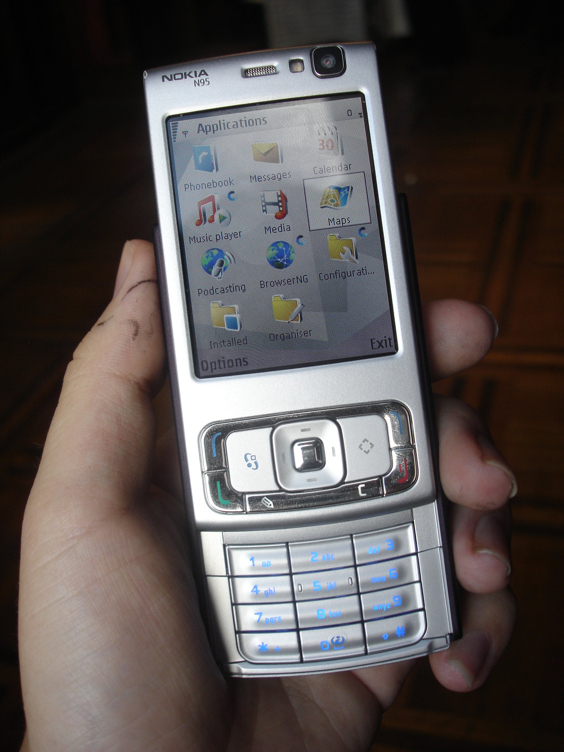
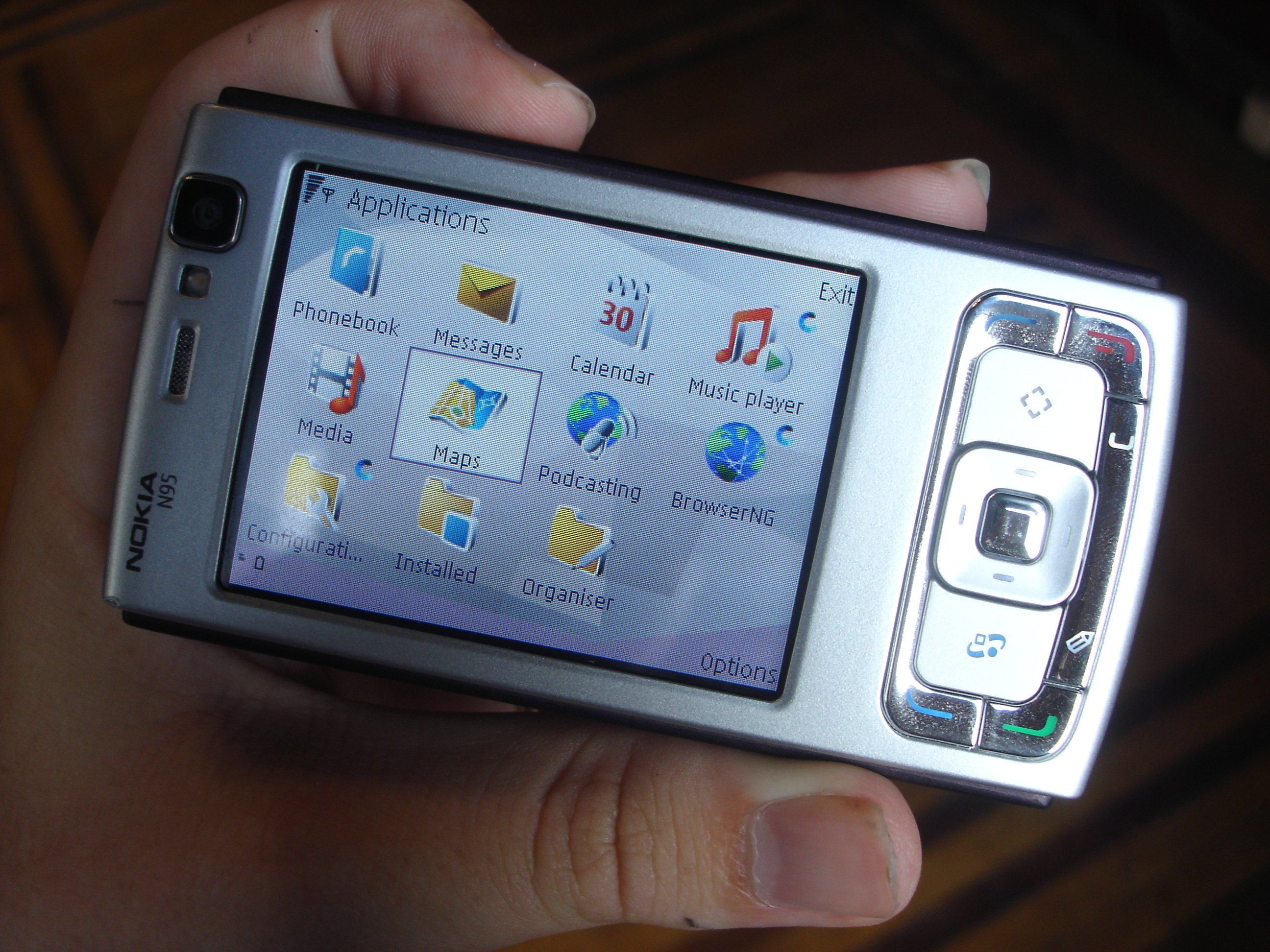