Microvision (MVIS) Blog: Telecoms, Web Firms Jostle Over Location Services
U.S. law requires all mobile phones to have an electronic signal, giving the owner's location, opening up a hot new market for Google, Microsoft, and others in addition to the usual telecom players.
By: Lucas van Grinsven and Tarmo Virki
BARCELONA (Reuters) - When U.S. regulators required that mobile handsets carry an electronic beacon giving the user's whereabouts, they handed telecoms and technology companies a hot new business opportunity.
Sprint Nextel and Verizon are already using the technology to help companies locate employees who are on the road and to aid travelers planning a weekend trip, charging up to $15 a month for their services.
But Google Inc. and other Web services firms are now stepping into the arena, threatening to bite into the phone companies' share of the market even as they offer opportunities for cooperation in new types of services.
Google, Yahoo Inc. and Microsoft Corp. have an edge over carriers because of their low costs and their ability to reach any customer with a browser -- increasingly a standard feature on cell phones.
"No group is better equipped to steal the march than the Internet services companies," said Mark Becker at Atos Consulting.
BOOST FROM U.S. INITIATIVE
Opportunities for location services got a major boost from the United States' e911 directive, which aims to help emergency workers to locate people in need.
In response, U.S. telecoms operators in the United States now sell mobile phones that contain a Global Positioning System (GPS) chip, which gives the user's precise position, and software to speed up the location process.
That software, which assists the GPS and hence is named Assisted-GPS, or A-GPS, is used in the services offered by Sprint and Verizon.
Only seven years ago, navigation systems that used GPS technology were an exclusive feature in expensive cars that added $3,000 or more to the vehicle's cost.
Around 2002, navigation systems, while still used mostly as a driving aid, broke below $1,000 for a handheld computer connected to a GPS unit.
Today a dedicated standalone navigation device from TomTom or Garmin, which a user can carry anywhere, costs as little as $300 and the companies estimate that 14 million units will be sold this year alone.
FOCUS ON SERVICES
Now that handsets in the United States and several Asian markets are being fitted with GPS locators, the focus is set to shift again, away from the hardware and 1-gigabyte memory cards that can store maps of entire continents, to navigation services.
This plays into the hands of Internet companies and threatens the profitable business of device makers.
"Access to location-based services via an Internet terminal, which can be a phone, means that the number of hits is the real value driver," said Fortis Bank's Oberdorfer.
All major navigation technology firms are present at this week's 3GSM conference in Barecelona, the world's biggest mobile communications trade show, as they target the 810-million-unit-a-year cell phone industry.
"All the navigation companies and all the Googles in this world are interested in the sector," said Panu Vuorela, chief executive of Finnish navigation software firm Navicore.
Mobile operators are wary that they may soon be subsidizing expensive handsets and upgrading their network to accommodate positioning technology, only for Google to start offering free navigation services paid by advertisers of area shops and facilities.
Google, on its Google Local service available in the United States and Britain, currently offers free navigation twinned with local businesses and services on desktop computers. It has taken the first tentative steps to bring the service to phones.
location based services
Friday, March 03, 2006


The Drive the streets of Seattle or San Francisco, CA using the Windows Live Local technology (Preview)
oday, via the Internet, Windows Live Local is offering up a limited Technical Preview of ‘street-side’ a new feature that Microsoft is building for its Windows Live Local consumer local search and mapping site. Street-side provides three new street-level vantage points for Windows Live Local users wanting a sneak preview of desired destinations, and surrounding visual cues on how to get there.
oday, via the Internet, Windows Live Local is offering up a limited Technical Preview of ‘street-side’ a new feature that Microsoft is building for its Windows Live Local consumer local search and mapping site. Street-side provides three new street-level vantage points for Windows Live Local users wanting a sneak preview of desired destinations, and surrounding visual cues on how to get there.
Some specifications and features of Street-Side:
- Street-side imagery will be available in a split screen navigation window. In the upper navigation pane, Windows Live Local users can view street-level imagery of their destinations. In the lower navigation pane, Windows Live Local users can switch between three navigation vehicles - race car, sports car, and walk-by - for varied approaches to using location information.
- Seattle and San Francisco are featured while dozens of additional cities are being driven [via a partnership with Facet Technology Corporation]. New cities will be added over time as Microsft prepares to add it to the main Windows Live Local site later this year.
- Street-side will augment the current road, aerial, and bird’s eye view that the Windows Live Local site already has today
- You can check it out at http://preview.local.live.com.

Drive the streets of Seattle using "Race Car" mode!

A search for "Starbucks in Seattle" yields a number of hits. Easily zoom to the location of click for additional info and the address. Map, image, or hybrid views are available.
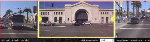
I like the walking tour - here I "walk" through San Francisco and check out the Pier - notice the left and right street side views as well as the landmark in the center... nice!
About Windows Live Technology Preview (Source: Microsoft)
| What is the Technology Preview? Walk, Drive, Race - in Street-Side Views - the application demonstrates our work-in-progress thinking about a rich immersive experience in mapping that also explores local information Why street-side views? How do I use the Technology Preview? Searching Using the Car Zooming Don’t like the Race Car? I’m lost! What now? Why only Seattle and San Francisco for Street Side? Can mashups be developed on top of a technology preview? Can I use street-side images in my Web site or other projects? What other projects are in the works? Check it out at http://preview.local.live.com | |
The Drive the streets of Seattle or San Francisco, CA using the Windows Live Local technology (Preview)
oday, via the Internet, Windows Live Local is offering up a limited Technical Preview of ‘street-side’ a new feature that Microsoft is building for its Windows Live Local consumer local search and mapping site. Street-side provides three new street-level vantage points for Windows Live Local users wanting a sneak preview of desired destinations, and surrounding visual cues on how to get there.
oday, via the Internet, Windows Live Local is offering up a limited Technical Preview of ‘street-side’ a new feature that Microsoft is building for its Windows Live Local consumer local search and mapping site. Street-side provides three new street-level vantage points for Windows Live Local users wanting a sneak preview of desired destinations, and surrounding visual cues on how to get there.
Some specifications and features of Street-Side:
- Street-side imagery will be available in a split screen navigation window. In the upper navigation pane, Windows Live Local users can view street-level imagery of their destinations. In the lower navigation pane, Windows Live Local users can switch between three navigation vehicles - race car, sports car, and walk-by - for varied approaches to using location information.
- Seattle and San Francisco are featured while dozens of additional cities are being driven [via a partnership with Facet Technology Corporation]. New cities will be added over time as Microsft prepares to add it to the main Windows Live Local site later this year.
- Street-side will augment the current road, aerial, and bird’s eye view that the Windows Live Local site already has today
- You can check it out at http://preview.local.live.com.
Drive the streets of Seattle using "Race Car" mode!
A search for "Starbucks in Seattle" yields a number of hits. Easily zoom to the location of click for additional info and the address. Map, image, or hybrid views are available.
I like the walking tour - here I "walk" through San Francisco and check out the Pier - notice the left and right street side views as well as the landmark in the center... nice!
About Windows Live Technology Preview (Source: Microsoft)
| What is the Technology Preview? Walk, Drive, Race - in Street-Side Views - the application demonstrates our work-in-progress thinking about a rich immersive experience in mapping that also explores local information Why street-side views? How do I use the Technology Preview? Searching Using the Car Zooming Don’t like the Race Car? I’m lost! What now? Why only Seattle and San Francisco for Street Side? Can mashups be developed on top of a technology preview? Can I use street-side images in my Web site or other projects? What other projects are in the works? Check it out at http://preview.local.live.com | |
The Where Is My All You Can Eat GPRS Plan - Until then, is text messaging the killer App?
Paying by the KB for data services will restrict the uptake of some amazing applications and services, additionally, smartphone features will go un-used and powerful, new devices will sit on the shelves until a suitable option like “All you can eat GPRS” or perhaps a 100MB monthly data plan (sub $30 please!) comes to the market. Mind-you, should free Wi-Fi hotspots proliferate, WiFi enabled devices like the Nokia Nseries, Eseries, 9300i, or SE 990 might in-fact be the solution.
$241.10… that’s the number I read in bold on a recent Rogers Wireless bill, this for having the privilege of using my smart phone. No doubt you’ve been there before - You spend a few days in another country, make a couple of calls, moblog a few pictures from your phone and voila… prepare yourself for a shock when the bill arrives. I should know better, however, something inside me keeps saying, ”maybe it won’t happen again this month”… forget about that! So I have to ask, with all the great devices on the market and all the fantastic applications available to users, how is one supposed to use these mobile services and applications without getting hit so hard in the wallet?
I love my smartphone as much as the next guy but when am I going to get my “all you can eat GPRS plan”, even more so, when are the carriers going to start marketing such plans effectively? Perhaps you’re not sure what I’m ranting about, or perhaps this scenario doesn’t happen in your part of the World, so, I’ll put it into context. I live in Canada and opt for a GPRS plan from Rogers wireless (AT&T). Wisely preparing for travel, I always pre-purchase additional data packets (a whopping 2MB for $12) so I can moblog, check email, chat, browse the web, or use other data services accessible from my Nokia 6682 (I’d use the Nokia 6680 but getting service from Rogers on this device is simply not an option in my locale… too bad… given that I shell out $200 a month quite often for their service you’d think they could support a “World phone”.
The kicker… even though I wisely pre-purchase data packets, here in North America the roaming charges are staggering and essentially serve as a tremendous barrier to entry for most people looking at using a GPRS smart phone. Something many “newbie” North-American-based smart phone users may not know, roaming charges apply not only to voice calls, they are also applied to text message and data usage. So, while on a recent business trip to Orlando, Florida, I decide to mo-blog some photos (low-resolution thank goodness!) to my flicker account – See Images from Orlando captured via my Nokia 6682 - http://www.flickr.com/photos/gisuser/sets/1435280/ . Using 2,330 KB of data services/uploads I am now the proud recipient of $116.55 in data roaming charges. Add on another $11 for text messaging roaming charges and $44 of voice roaming charges and you can sense the frustration when browsing my 8 page phone bill.
For me I look at the unrealistic charges as the cost of doing business. In my line of work I’m expected to have a mobile device at the ready, be prepared to upload photos and correspond via email… I can live with it I suppose. Can I accept the fact? Sorry but no can do. Joe public will never be willing to accept this scenario, not in North America anyway. Are there solutions? Perhaps… first and foremost, carriers like Rogers need to provide better information for travelers. Online marketing material for plans and options needs to be vastly improved, customer service needs to be improved BIG TIME, and geographic disparities in plan offerings need to be eliminated. Roaming charges and agreements need to be secured amongst North American carriers… whatever happened to North American Free trade?
These problems are by no means restricted to Canada or North America for that matter. Regardless of where you reside you need to be aware of the charges and hidden-fees that may creep onto your cell plan bill, particularly while roaming from your carrier’s territory. How to save $$ in the mean time? Use text messaging and minimize data throughput. Get yourself a Wi-Fi enabled device and take advantage of free Internet access (not always an option). Other solutions… lug a “portable” notebook around and access your Internet and email using that device (not always a viable option). Final option, consider a Blackberry for use while traveling.
Do you have a similar story? Do you have a solution or can you suggest a plan, device, or other suitable alternative? We’d love to hear your thoughts.
Note: A typical Rogers wireless monthly GPRS plan that includes 2 MB data access, text messaging (simple plan) and 150 talk time costs between $60-$75… roaming and over-limit/usage charges not included.
A UK Perspective
In a related scenario providing the UK perspective along with some fine user feedback – Steve Litchfield at AAS recently published a piece titled Making no sense without flat rate GPRS – from Steve… There's a veritable flood of Internet-borne 'services' that you access on your smartphone coming out of America (and specifically the CES show) but what they're announcing makes no sense whatsoever in most of the rest of the world.
So here I am, watching all the amazing new devices (like the N-Series line up) come to market. Imaging, messaging, Internet, Video, television, yadayada. I can't wait to get my hands on a new device (like the Nseries, Eseries, a 9300i, or a Sony Ericsson 990 - all of which are Wi-Fi enabled.. sweet!) These devices all have a pretty hefty price tag, however, throw in Wi-Fi access and it could be that maybe I can't afford not to have one! Device convergence may be all for not though, as the best solution might be to use my cell phone for all my VOICE apps (there's an interesting concept) and a second device like the recently launched Nokia 770 Internet tablet whenever free Wi-Fi hotspots are in proximity... sounds good to me! (The 770 retails for about $350). Those looking to use one device will no doubt embrace the latest Wi-Fi enabled devices previously mentioned... those who have room for 2 devices and need a larger form factor will consider the 770. Is the 770 ahead of its time? Will it go the way of the N-Gage? Are users ready for a Linux device? These questions will be answered as we head into 2006.
Do You have advice or comments??
Nokia 770 Internet Tablet
The large screen makes browsing the Internet using the 770 a very comfortable experience - at $350 US (approx) this could be THE device for 2006!
For related information, see this post titled "Browsing: The Mobile Data Killer App" at Russell Beattie's weblog and details of this recent Nokia study on smartphone usage (Source: Simon Judge). See also this report on Mobile Data service usage by Telphia (PDF)
< Pre
location based services
Paying by the KB for data services will restrict the uptake of some amazing applications and services, additionally, smartphone features will go un-used and powerful, new devices will sit on the shelves until a suitable option like “All you can eat GPRS” or perhaps a 100MB monthly data plan (sub $30 please!) comes to the market. Mind-you, should free Wi-Fi hotspots proliferate, WiFi enabled devices like the Nokia Nseries, Eseries, 9300i, or SE 990 might in-fact be the solution.
$241.10… that’s the number I read in bold on a recent Rogers Wireless bill, this for having the privilege of using my smart phone. No doubt you’ve been there before - You spend a few days in another country, make a couple of calls, moblog a few pictures from your phone and voila… prepare yourself for a shock when the bill arrives. I should know better, however, something inside me keeps saying, ”maybe it won’t happen again this month”… forget about that! So I have to ask, with all the great devices on the market and all the fantastic applications available to users, how is one supposed to use these mobile services and applications without getting hit so hard in the wallet?
I love my smartphone as much as the next guy but when am I going to get my “all you can eat GPRS plan”, even more so, when are the carriers going to start marketing such plans effectively? Perhaps you’re not sure what I’m ranting about, or perhaps this scenario doesn’t happen in your part of the World, so, I’ll put it into context. I live in Canada and opt for a GPRS plan from Rogers wireless (AT&T). Wisely preparing for travel, I always pre-purchase additional data packets (a whopping 2MB for $12) so I can moblog, check email, chat, browse the web, or use other data services accessible from my Nokia 6682 (I’d use the Nokia 6680 but getting service from Rogers on this device is simply not an option in my locale… too bad… given that I shell out $200 a month quite often for their service you’d think they could support a “World phone”.
The kicker… even though I wisely pre-purchase data packets, here in North America the roaming charges are staggering and essentially serve as a tremendous barrier to entry for most people looking at using a GPRS smart phone. Something many “newbie” North-American-based smart phone users may not know, roaming charges apply not only to voice calls, they are also applied to text message and data usage. So, while on a recent business trip to Orlando, Florida, I decide to mo-blog some photos (low-resolution thank goodness!) to my flicker account – See Images from Orlando captured via my Nokia 6682 - http://www.flickr.com/photos/gisuser/sets/1435280/ . Using 2,330 KB of data services/uploads I am now the proud recipient of $116.55 in data roaming charges. Add on another $11 for text messaging roaming charges and $44 of voice roaming charges and you can sense the frustration when browsing my 8 page phone bill.
For me I look at the unrealistic charges as the cost of doing business. In my line of work I’m expected to have a mobile device at the ready, be prepared to upload photos and correspond via email… I can live with it I suppose. Can I accept the fact? Sorry but no can do. Joe public will never be willing to accept this scenario, not in North America anyway. Are there solutions? Perhaps… first and foremost, carriers like Rogers need to provide better information for travelers. Online marketing material for plans and options needs to be vastly improved, customer service needs to be improved BIG TIME, and geographic disparities in plan offerings need to be eliminated. Roaming charges and agreements need to be secured amongst North American carriers… whatever happened to North American Free trade?
These problems are by no means restricted to Canada or North America for that matter. Regardless of where you reside you need to be aware of the charges and hidden-fees that may creep onto your cell plan bill, particularly while roaming from your carrier’s territory. How to save $$ in the mean time? Use text messaging and minimize data throughput. Get yourself a Wi-Fi enabled device and take advantage of free Internet access (not always an option). Other solutions… lug a “portable” notebook around and access your Internet and email using that device (not always a viable option). Final option, consider a Blackberry for use while traveling.
Do you have a similar story? Do you have a solution or can you suggest a plan, device, or other suitable alternative? We’d love to hear your thoughts.
Note: A typical Rogers wireless monthly GPRS plan that includes 2 MB data access, text messaging (simple plan) and 150 talk time costs between $60-$75… roaming and over-limit/usage charges not included.
A UK Perspective
In a related scenario providing the UK perspective along with some fine user feedback – Steve Litchfield at AAS recently published a piece titled Making no sense without flat rate GPRS – from Steve… There's a veritable flood of Internet-borne 'services' that you access on your smartphone coming out of America (and specifically the CES show) but what they're announcing makes no sense whatsoever in most of the rest of the world.
So here I am, watching all the amazing new devices (like the N-Series line up) come to market. Imaging, messaging, Internet, Video, television, yadayada. I can't wait to get my hands on a new device (like the Nseries, Eseries, a 9300i, or a Sony Ericsson 990 - all of which are Wi-Fi enabled.. sweet!) These devices all have a pretty hefty price tag, however, throw in Wi-Fi access and it could be that maybe I can't afford not to have one! Device convergence may be all for not though, as the best solution might be to use my cell phone for all my VOICE apps (there's an interesting concept) and a second device like the recently launched Nokia 770 Internet tablet whenever free Wi-Fi hotspots are in proximity... sounds good to me! (The 770 retails for about $350). Those looking to use one device will no doubt embrace the latest Wi-Fi enabled devices previously mentioned... those who have room for 2 devices and need a larger form factor will consider the 770. Is the 770 ahead of its time? Will it go the way of the N-Gage? Are users ready for a Linux device? These questions will be answered as we head into 2006.
Do You have advice or comments??
Nokia 770 Internet Tablet
The large screen makes browsing the Internet using the 770 a very comfortable experience - at $350 US (approx) this could be THE device for 2006!
For related information, see this post titled "Browsing: The Mobile Data Killer App" at Russell Beattie's weblog and details of this recent Nokia study on smartphone usage (Source: Simon Judge). See also this report on Mobile Data service usage by Telphia (PDF)
< Pre
location based services
Trimble Introduces Tiny Surface Mount GPS Receiver
Trimble Introduces Tiny Surface Mount GPS Receiver Trimble has introduced today its new Copernicus GPS receiver, a thumbnail-sized, surface-mount, low power module ideal for adding Global Positioning System (GPS) capabilities to Bluetooth appliances, sport accessories, personal navigators or cameras, computer and communication peripherals as well as vehicle tracking, navigation, and security products.
The Copernicus GPS module is a complete drop-in, ready-to-go receiver that provides position, velocity and time data. The receiver features a new Trimble TrimCore software technology that provides extremely fast startup times and high performance in foliage and urban canyon environments.
Compatible with active or passive antennas, the Copernicus GPS receiver can be used in next-generation portable handheld, battery-powered applications.
Copernicus is a complete 12-channel GPS receiver in a 19mm x 19mm x 2.5mm shielded module. The company says the ultra-sensitive Copernicus GPS receiver can acquire satellite signals and generate position fixes with high accuracy in extremely challenging environments and under poor signal conditions.
The Copernicus GPS module is available in three protocols. Trimble's own TSIP protocol offers complete control over receiver operation and provides detailed satellite information. The TAIP protocol is an easy-to-use ASCII protocol designed specifically for track and trace applications. The bi-directional NMEA 0183 v3.0 protocol offers industry standard data messages and a command set for easy interface to mapping software.
The Copernicus GPS receiver is expected to be available in the third quarter of 2006 through Trimble's Component Technologies dealer network.
location based services
Trimble Introduces Tiny Surface Mount GPS Receiver Trimble has introduced today its new Copernicus GPS receiver, a thumbnail-sized, surface-mount, low power module ideal for adding Global Positioning System (GPS) capabilities to Bluetooth appliances, sport accessories, personal navigators or cameras, computer and communication peripherals as well as vehicle tracking, navigation, and security products.
The Copernicus GPS module is a complete drop-in, ready-to-go receiver that provides position, velocity and time data. The receiver features a new Trimble TrimCore software technology that provides extremely fast startup times and high performance in foliage and urban canyon environments.
Compatible with active or passive antennas, the Copernicus GPS receiver can be used in next-generation portable handheld, battery-powered applications.
Copernicus is a complete 12-channel GPS receiver in a 19mm x 19mm x 2.5mm shielded module. The company says the ultra-sensitive Copernicus GPS receiver can acquire satellite signals and generate position fixes with high accuracy in extremely challenging environments and under poor signal conditions.
The Copernicus GPS module is available in three protocols. Trimble's own TSIP protocol offers complete control over receiver operation and provides detailed satellite information. The TAIP protocol is an easy-to-use ASCII protocol designed specifically for track and trace applications. The bi-directional NMEA 0183 v3.0 protocol offers industry standard data messages and a command set for easy interface to mapping software.
The Copernicus GPS receiver is expected to be available in the third quarter of 2006 through Trimble's Component Technologies dealer network.
location based services
Free Earthcomber Software for Windows Mobile Debuts
Users of Windows Mobile-based handhelds now have a new way to shop, travel and comb the surrounding area for anything they want. Earthcomber is a free service that started on the Palm-powered platform and is now migrating to the Windows Mobile Pocket PC and Smartphone realm.
Earthcomber appears like any other type of navigation software, except that its GPS-enabled maps for all territories in the USA are missing a price tag. All maps, “Look Lists” and “Community” features are entirely free.
Users can specify exact types of restaurants, shops, ATMs, hotels, landmarks and plot them on a map, as well as join or create groups that let them share or discover spots like where movies were shot, sites of public art or places to spot wildlife or enjoy dog parks, pictures, picnics, or freebies.
The new Windows Mobile version of Earthcomber includes a point-to-point direction feature that requires a phone or Internet connection. Earthcomber makes it easy to connect from a mobile device via the "WiFi hotspot location" data set included with every Earthcomber map.
Even for basic PDAs that do not have any WiFi connection, cellular service or GPS capability, Earthcomber can still provide “combing” or sweeps of a person’s current surroundings via its touch-screen maps calibrated to figure out distances. For instance, a person can simply plant their “X” by tapping the screen on the intersection where they are, or by looking up an address. Then Earthcomber reports any and all “hits,” just as if a GPS signal spotted the location on the map.
Users can also purchase a new breed of guidebook from publishers such as Mobil Travel Guides, Avalon Publishing’s Moon Metro Series, and Fairchild & Gallagher’s Where to Wear insider fashion shopping guides.
These guides feature unabridged versions of the paper editions, but empower them with GPS awareness and personalized search. Earthcomber Spot Guides range from free to US$19.85. Spot Guides let users customize their interests – and how far to search for each one – and then alert them when they come within a certain distance or nearby any location that has one or more of their personal favorites in food, shopping, public places, natural features, historic sites or private pursuits.
Earthcomber supports devices based on Windows Mobile 2003 and newer Windows Mobile versions.
location based services
Users of Windows Mobile-based handhelds now have a new way to shop, travel and comb the surrounding area for anything they want. Earthcomber is a free service that started on the Palm-powered platform and is now migrating to the Windows Mobile Pocket PC and Smartphone realm.
Earthcomber appears like any other type of navigation software, except that its GPS-enabled maps for all territories in the USA are missing a price tag. All maps, “Look Lists” and “Community” features are entirely free.
Users can specify exact types of restaurants, shops, ATMs, hotels, landmarks and plot them on a map, as well as join or create groups that let them share or discover spots like where movies were shot, sites of public art or places to spot wildlife or enjoy dog parks, pictures, picnics, or freebies.
The new Windows Mobile version of Earthcomber includes a point-to-point direction feature that requires a phone or Internet connection. Earthcomber makes it easy to connect from a mobile device via the "WiFi hotspot location" data set included with every Earthcomber map.
Even for basic PDAs that do not have any WiFi connection, cellular service or GPS capability, Earthcomber can still provide “combing” or sweeps of a person’s current surroundings via its touch-screen maps calibrated to figure out distances. For instance, a person can simply plant their “X” by tapping the screen on the intersection where they are, or by looking up an address. Then Earthcomber reports any and all “hits,” just as if a GPS signal spotted the location on the map.
Users can also purchase a new breed of guidebook from publishers such as Mobil Travel Guides, Avalon Publishing’s Moon Metro Series, and Fairchild & Gallagher’s Where to Wear insider fashion shopping guides.
These guides feature unabridged versions of the paper editions, but empower them with GPS awareness and personalized search. Earthcomber Spot Guides range from free to US$19.85. Spot Guides let users customize their interests – and how far to search for each one – and then alert them when they come within a certain distance or nearby any location that has one or more of their personal favorites in food, shopping, public places, natural features, historic sites or private pursuits.
Earthcomber supports devices based on Windows Mobile 2003 and newer Windows Mobile versions.
location based services
Mobile Monday - Breaking News: Nokia and Telenor R&D test converged services
Nokia and Telenor R&D are jointly trialing services for fixed and mobile environments using Fixed-Mobile Convergence technologies.
The results of the research and development collaboration include the ability to deliver IP Multimedia Subsystem (IMS) services over Nokia’s D500 DSLAM multiservice broadband platform; VoIP calls between mobile and fixed SIP (Session Initiation Protocol) clients; and establishing test capabilities for gaming and video sharing on a converged platform.
The joint project began in 2005, seeking to assess how different IP services can be delivered over multiple access technologies like WLAN/DSL, GSM and WCDMA to a multiradio device such as the Nokia E60.
The Fixed-Mobile Convergence architecture is based on SIP technology and the Nokia IMS solution. With converged IP services, users will be able to integrate voice, video, text, content sharing and presence in a single communications session, regardless of the access network; for example, VoIP could be used over both a fixed network and WLAN (Wireless LAN) using IMS. The joint project will continue until end of 2006.
“The shift towards IP convergence over the next few years is clear to Telenor. Introducing an IMS-based architecture is central to this development,” says Hans-Christian Haugli, CEO Telenor R&D. “Taking a proactive role in the development positions us well to offer IP-based multimedia services to our customers.”
As defined by 3GPP standard, IMS will form the heart of the converged network of the future, and will provide authentication, roaming and network interconnectivity for IP-enabled terminals. The use of IP in core networks makes possible new service concepts and convergence between fixed and mobile networks.
Nokia ssays that it is the front runner in IMS for fixed and mobile networks, with over 70 references for IMS solutions, such as Push to talk over Cellular and video sharing. Nokia has also taken the lead in fixed mobile convergence, with 11 network customers.
Related News
* Visiongain: Convergence will stimulate billing sector
* VoWLAN poised for huge growth
* NEC licenses Ericsson’s latest 3G-phone design
* Jumping between networks
* Kodiak Networks announces integrated IMS and OMA/PoC system
* Ericsson pushes talk to Siemens handsets
* Ericsson CEO talks up broadband 3g
* Nokia and NEC test interoperability of for richer communications
* Intec buys Danish Digiquant
location based services
Nokia and Telenor R&D are jointly trialing services for fixed and mobile environments using Fixed-Mobile Convergence technologies.
The results of the research and development collaboration include the ability to deliver IP Multimedia Subsystem (IMS) services over Nokia’s D500 DSLAM multiservice broadband platform; VoIP calls between mobile and fixed SIP (Session Initiation Protocol) clients; and establishing test capabilities for gaming and video sharing on a converged platform.
The joint project began in 2005, seeking to assess how different IP services can be delivered over multiple access technologies like WLAN/DSL, GSM and WCDMA to a multiradio device such as the Nokia E60.
The Fixed-Mobile Convergence architecture is based on SIP technology and the Nokia IMS solution. With converged IP services, users will be able to integrate voice, video, text, content sharing and presence in a single communications session, regardless of the access network; for example, VoIP could be used over both a fixed network and WLAN (Wireless LAN) using IMS. The joint project will continue until end of 2006.
“The shift towards IP convergence over the next few years is clear to Telenor. Introducing an IMS-based architecture is central to this development,” says Hans-Christian Haugli, CEO Telenor R&D. “Taking a proactive role in the development positions us well to offer IP-based multimedia services to our customers.”
As defined by 3GPP standard, IMS will form the heart of the converged network of the future, and will provide authentication, roaming and network interconnectivity for IP-enabled terminals. The use of IP in core networks makes possible new service concepts and convergence between fixed and mobile networks.
Nokia ssays that it is the front runner in IMS for fixed and mobile networks, with over 70 references for IMS solutions, such as Push to talk over Cellular and video sharing. Nokia has also taken the lead in fixed mobile convergence, with 11 network customers.
Related News
* Visiongain: Convergence will stimulate billing sector
* VoWLAN poised for huge growth
* NEC licenses Ericsson’s latest 3G-phone design
* Jumping between networks
* Kodiak Networks announces integrated IMS and OMA/PoC system
* Ericsson pushes talk to Siemens handsets
* Ericsson CEO talks up broadband 3g
* Nokia and NEC test interoperability of for richer communications
* Intec buys Danish Digiquant
location based services
Thursday, March 02, 2006
Annotated environments, intelligent infrastructure and digital landscapes - Smartspace - DIY Google Map Mashup in Jotspot
Today's postings seem to have a theme - basic Web apps. I am a new user of Jotspot, the Web-based wiki platform. One of Jotspots useful apps is Tracker, an online spreadsheet application that allows multiple users to collaborate on a spreadsheet real-time. One feature of this is the ability to quickly plot addresses entered into a spreadsheet format on a Google Map.
In my case, it was simply to plot the location of my son's soccer team to better locate a central practice field. But in a couple of keystrokes it was done - I had created a custom Google Map with each player's home as a marker. Probably killing a fly with a sledgehammer, but the easy import function made it seem like a quick way to get an idea of where we all live in relation to one another.
Posted on February 28, 2006 by Scott Smith in Mashups | Post a Comment
Reader Comments
There are no comments for this journal entry. To create a new comment, use the form below.
Post a New Comment
Enter your information below
Today's postings seem to have a theme - basic Web apps. I am a new user of Jotspot, the Web-based wiki platform. One of Jotspots useful apps is Tracker, an online spreadsheet application that allows multiple users to collaborate on a spreadsheet real-time. One feature of this is the ability to quickly plot addresses entered into a spreadsheet format on a Google Map.
In my case, it was simply to plot the location of my son's soccer team to better locate a central practice field. But in a couple of keystrokes it was done - I had created a custom Google Map with each player's home as a marker. Probably killing a fly with a sledgehammer, but the easy import function made it seem like a quick way to get an idea of where we all live in relation to one another.
Posted on February 28, 2006 by Scott Smith in Mashups | Post a Comment
Reader Comments
There are no comments for this journal entry. To create a new comment, use the form below.
Post a New Comment
Enter your information below
Phone, media firms see mobile ads soon
Cell phone and media companies expect to see a sizable market for advertising on cell phones in coming years, with options including advertising-subsidized video services, top executives said Wednesday.
Viacom, which runs MTV and Comedy Central, is working with major operators, and plans to play a major role in the first trials of mobile ads in the next year. Sprint Nextel, the No. 3 U.S. mobile provider, is keen to offer subsidized wireless videos and local ads to cell phones.
"There's no question that advertisers are interested," said Viacom Chief Executive Tom Freston, speaking in New York at the Reuters Global Technology, Media and Telecoms Summit.
Freston said Viacom, which works with about 70 cell phone companies around the world, is talking to "various" operators about details of how advertising could work. He believes mobile video ads would have to be very short to succeed, and would depend on customers allowing them in exchange for deals on their cell phone.
"What amount of advertising are they willing to accept in exchange for lower fees," he said.
As it aims to boost revenue with new features like video, Sprint Nextel is also looking at technology and business models around providing advertising to people using these services.
Sprint Nextel Chief Technology Officer Barry West pointed to the possibilities for sending information such as special offers at a local Italian restaurant to phones that can pinpoint the user's location.
"The whole advertising world has a new mechanism to reach their customers. You can hone in on customers in your area," said West, who was also speaking at the summit.
Sprint could also offer its cheaper mobile video services if an ad is included, its Chief Financial Officer said.
"There are some people who would be willing to have their services subsidized," Sprint CFO Paul Saleh said. Sprint will work on cell phone advertising in the next couple of years.
In other news:
Microsoft whispers Origami details
Google's goal: 'Biggest footprint'
Ideas on display at Microsoft's TechFest
News.com Extra: Russian game developer takes on consoles
Advertisers are also keen on the prospects for putting ads on cell phones and particularly via mobile video services.
"It's a major opportunity." Martin Sorrell, chief executive of WPP Group, the world's second largest advertising and marketing company, said at the summit.
Sorrell said the methods of measuring how many people see the advertising have yet to be determined, but that measurability was a key attraction.
"People will experiment," he said. "They won't make the decision to put millions of dollars in it (immediately). They'll make the decision on an exploratory basis."
Asked when it would become mainstream, he answered, "Quickly."
Story Copyright © 2006 Reuters Limited. All rights reserved.
TalkBack E-mail
location based services
Cell phone and media companies expect to see a sizable market for advertising on cell phones in coming years, with options including advertising-subsidized video services, top executives said Wednesday.
Viacom, which runs MTV and Comedy Central, is working with major operators, and plans to play a major role in the first trials of mobile ads in the next year. Sprint Nextel, the No. 3 U.S. mobile provider, is keen to offer subsidized wireless videos and local ads to cell phones.
"There's no question that advertisers are interested," said Viacom Chief Executive Tom Freston, speaking in New York at the Reuters Global Technology, Media and Telecoms Summit.
Freston said Viacom, which works with about 70 cell phone companies around the world, is talking to "various" operators about details of how advertising could work. He believes mobile video ads would have to be very short to succeed, and would depend on customers allowing them in exchange for deals on their cell phone.
"What amount of advertising are they willing to accept in exchange for lower fees," he said.
As it aims to boost revenue with new features like video, Sprint Nextel is also looking at technology and business models around providing advertising to people using these services.
Sprint Nextel Chief Technology Officer Barry West pointed to the possibilities for sending information such as special offers at a local Italian restaurant to phones that can pinpoint the user's location.
"The whole advertising world has a new mechanism to reach their customers. You can hone in on customers in your area," said West, who was also speaking at the summit.
Sprint could also offer its cheaper mobile video services if an ad is included, its Chief Financial Officer said.
"There are some people who would be willing to have their services subsidized," Sprint CFO Paul Saleh said. Sprint will work on cell phone advertising in the next couple of years.
In other news:
Microsoft whispers Origami details
Google's goal: 'Biggest footprint'
Ideas on display at Microsoft's TechFest
News.com Extra: Russian game developer takes on consoles
Advertisers are also keen on the prospects for putting ads on cell phones and particularly via mobile video services.
"It's a major opportunity." Martin Sorrell, chief executive of WPP Group, the world's second largest advertising and marketing company, said at the summit.
Sorrell said the methods of measuring how many people see the advertising have yet to be determined, but that measurability was a key attraction.
"People will experiment," he said. "They won't make the decision to put millions of dollars in it (immediately). They'll make the decision on an exploratory basis."
Asked when it would become mainstream, he answered, "Quickly."
Story Copyright © 2006 Reuters Limited. All rights reserved.
TalkBack E-mail
location based services
Amplifier module is a product of the year: News from Avago Technologies
The ALM-1106 ultra-low-noise amplifier module used for enhancing performance in GPS handsets has been named a 2005 Product of the Year by analogueZone.
Note: Readers of the Editor’s free email newsletter will have read this news when it was announced. Send us a blank email now to join the circulation. It’s free!
The ALM-1106 ultra-low-noise amplifier (LNA) module used for enhancing performance in GPS handsets has been named a 2005 Product of the Year by analogueZone. Each year analogueZone recognises award winners for product design and performance, likely contribution to the field of analogue engineering and anticipated market success. The Avago Technologies ALM-1106's combination of a low-noise figure to improve sensitivity, miniature size, low-voltage operation, low device current, and battery-saving features such as integrated shutdown capability makes the amplifier module an ideal choice for GPS receivers incorporated in handsets.
The ALM-1106 also enables concurrent GPS capability with the industry's highest linearity (third-order intercept of 4.7dBm) and lowest noise figure (0.8dB) performance.
As cellular handset manufacturers start offering location-based services to comply with the US Federal Communications Commission's Wireless Enhanced 911 (E911) mandate, service providers will require enhanced GPS sensitivity, which can only be met with a high-performance GPS LNA.
Avago Technologies' monolithic microwave integrated circuit (MMIC) LNA module is also ideal for IEEE802.11b and 802.11g Wi-Fi receivers and receivers for 2GHz and 3.5GHz IEEE802.16 WiMAX (wireless microwave access)/BWA (broadband wireless access).
'Each year the editors at analogueZone go through a rigorous process in selecting the most outstanding products of the year', said Paul McGoldrick, Editor-in-Chief of analogueZone.
'Avago has repeatedly proven its expertise in the design of microwave components based on its rich R and D heritage - the low-noise amplifier has winner written all over it and deservedly so for such a well-controlled performer'.
'We are honoured to receive this award from analogueZone', said Bryan Ingram, Vice President and General Manager for the wireless semiconductor Division at Avago Technologies.
'The award confirms our commitment to continuously delivering products with increased performance while lowering the material costs for our customers'.
• Avago Technologies: contact details and other news
• Other news in Communications ICs (Wireless)
• Email this news to a colleague
• Send us a blank email now to get the Editor’s free regular email newsletter
• RSS news feed for Avago Technologies
• RSS news feed for Communications ICs (Wireless)
• Electronicstalk Home Page
The ALM-1106 ultra-low-noise amplifier module used for enhancing performance in GPS handsets has been named a 2005 Product of the Year by analogueZone.
Note: Readers of the Editor’s free email newsletter will have read this news when it was announced. Send us a blank email now to join the circulation. It’s free!
The ALM-1106 ultra-low-noise amplifier (LNA) module used for enhancing performance in GPS handsets has been named a 2005 Product of the Year by analogueZone. Each year analogueZone recognises award winners for product design and performance, likely contribution to the field of analogue engineering and anticipated market success. The Avago Technologies ALM-1106's combination of a low-noise figure to improve sensitivity, miniature size, low-voltage operation, low device current, and battery-saving features such as integrated shutdown capability makes the amplifier module an ideal choice for GPS receivers incorporated in handsets.
The ALM-1106 also enables concurrent GPS capability with the industry's highest linearity (third-order intercept of 4.7dBm) and lowest noise figure (0.8dB) performance.
As cellular handset manufacturers start offering location-based services to comply with the US Federal Communications Commission's Wireless Enhanced 911 (E911) mandate, service providers will require enhanced GPS sensitivity, which can only be met with a high-performance GPS LNA.
Avago Technologies' monolithic microwave integrated circuit (MMIC) LNA module is also ideal for IEEE802.11b and 802.11g Wi-Fi receivers and receivers for 2GHz and 3.5GHz IEEE802.16 WiMAX (wireless microwave access)/BWA (broadband wireless access).
'Each year the editors at analogueZone go through a rigorous process in selecting the most outstanding products of the year', said Paul McGoldrick, Editor-in-Chief of analogueZone.
'Avago has repeatedly proven its expertise in the design of microwave components based on its rich R and D heritage - the low-noise amplifier has winner written all over it and deservedly so for such a well-controlled performer'.
'We are honoured to receive this award from analogueZone', said Bryan Ingram, Vice President and General Manager for the wireless semiconductor Division at Avago Technologies.
'The award confirms our commitment to continuously delivering products with increased performance while lowering the material costs for our customers'.
• Avago Technologies: contact details and other news
• Other news in Communications ICs (Wireless)
• Email this news to a colleague
• Send us a blank email now to get the Editor’s free regular email newsletter
• RSS news feed for Avago Technologies
• RSS news feed for Communications ICs (Wireless)
• Electronicstalk Home Page
GPS Module is based on mixed-signal CMOS RFIC., RF Micro Devices, Inc.
The plans were discussed in January at a presidential summit
Officials from Argentina, Brazil and Venezuela are meeting in Caracas to lay the foundations for a jointly-financed gas pipeline.
The 8,000km (5,000 miles) pipeline would provide Venezuelan gas to much of South America.
It will cut across the Amazon rainforest and run all the way to the southern tip of the continent, and its price tag is $20bn.
Further details are expected to be announced later on Thursday.
The difficulty of the proposed construction is reflected in the size of the government delegations involved in the meeting in Caracas.
Some 20 engineers and economists representing Argentina, Brazil and Venezuela have spent the past day discussing the route of the pipeline, its cost and environmental impact on the Amazon rainforest.
'Political decision'
Now their bosses - Argentina's minister for planning and the energy ministers of Brazil and Venezuela - are expected to unveil some of those technical details after almost two days of discussions.
Venezuela's Energy Minister, Rafael Ramirez, told the BBC the project would contribute towards political and economic unity in South America.
"We've already taken the political decision to build this pipeline. Now we're discussing the technicalities," Mr Ramirez said.
So far it is not clear how the construction costs will be distributed among the contributing governments.
Argentina and Brazil are quietly confident that Venezuela with its oil riches may end up paying more than half of the costs.
If they fail to reach consensus on this occasion, the issue is likely to be taken up again by the Presidents of Venezuela, Argentina and Brazil, at their trilateral summit in just over a week's time.
E-mail this to a friend Printable version
LINKS TO
The plans were discussed in January at a presidential summit
Officials from Argentina, Brazil and Venezuela are meeting in Caracas to lay the foundations for a jointly-financed gas pipeline.
The 8,000km (5,000 miles) pipeline would provide Venezuelan gas to much of South America.
It will cut across the Amazon rainforest and run all the way to the southern tip of the continent, and its price tag is $20bn.
Further details are expected to be announced later on Thursday.
The difficulty of the proposed construction is reflected in the size of the government delegations involved in the meeting in Caracas.
Some 20 engineers and economists representing Argentina, Brazil and Venezuela have spent the past day discussing the route of the pipeline, its cost and environmental impact on the Amazon rainforest.
'Political decision'
Now their bosses - Argentina's minister for planning and the energy ministers of Brazil and Venezuela - are expected to unveil some of those technical details after almost two days of discussions.
Venezuela's Energy Minister, Rafael Ramirez, told the BBC the project would contribute towards political and economic unity in South America.
"We've already taken the political decision to build this pipeline. Now we're discussing the technicalities," Mr Ramirez said.
So far it is not clear how the construction costs will be distributed among the contributing governments.
Argentina and Brazil are quietly confident that Venezuela with its oil riches may end up paying more than half of the costs.
If they fail to reach consensus on this occasion, the issue is likely to be taken up again by the Presidents of Venezuela, Argentina and Brazil, at their trilateral summit in just over a week's time.
E-mail this to a friend Printable version
LINKS TO
Wednesday, March 01, 2006
Unit 014 - Latitude and Longitude
Unit 014 - Latitude and Longitude
by Anthony P. Kirvan, Department of Geography, University of Texas at Austin, USA
This section was edited by Kenneth Foote, Department of Geography, University of Texas Austin.
This unit is part of the NCGIA Core Curriculum in Geographic Information Science. These materials may be used for study, research, and education, but please credit the author, Anthony P. Kirvan, and the project, NCGIA Core Curriculum in GIScience. All commercial rights reserved. Copyright 1997 by Anthony P. Kirvan.
Your comments on these materials are welcome. A link to an evaluation form is provided at the end of this document.
--------------------------------------------------------------------------------
Advanced Organizer
Topics covered in this unit
This unit provides an overview of latitude and longitude, including:
Earth rotation, the North and South Poles, and the Equator
Parallels of latitude and meridians of longitude
Determination of north or south position with latitude
The use of longitude to determine east or west position
The measurement of latitude and longitude with degrees, minutes, and seconds
Learning Outcomes
After learning the material covered in this unit, students should gain an appreciation for:
The relationship between plane and earth coordinate geometries
The importance of the earth's rotation and poles to measurement and point location
The use of latitude and longitude to determine locations on the earth's surface
The differences and relationships between latitude and longitude
Using latitude and longitude to measure distances
Instructors' Notes
Full Table of Contents
Metadata and Revision History
--------------------------------------------------------------------------------
Unit 014 - Latitude and Longitude
1. Frames of Reference
Throughout history, many methods of keeping track of locations have been developed.
Plane coordinate geometry was developed as an abstract frame of reference for flat surfaces.
Once the earth's round, three-dimensional shape was accepted, a spherical coordinate system was created to determine locations around the world.
1.1. Plane Coordinate Geometry
Ren頼FONT size=+0>Descartes' contributions to mathematics were developed into cartesian coordinate geometry.
This is the familiar system of equally-spaced intersecting perpendicular lines in a single plane.
The two principle axes are the horizontal (x) and the vertical (y) .
Any point's position can be described with respect to its corresponding x and y values (x,y).
Figure 1. The position (5,3) is a unique location easily plotted on the cartesian plane.
The position of one point relative to another can also be shown with the cartesian coordinate system.
--------------------------------------------------------------------------------
2. Earth Coordinate Geometry
The earth's spherical shape is more difficult to describe than a plane surface.
Concepts from cartesian coordinate geometry have been incorporated into the earth's coordinate system.
2.1. Rotation of the Earth
The spinning of the earth on its imaginary axis is called rotation.
Aside from the cultural influences of rotation, this spinning also has a physical influence.
The spinning has led to the creation of a system to determine points and directions on the sphere.
The North and South poles represent the axis of spin and are fixed reference points.
If the North Pole was extended, it would point to a fixed star, the North Star (Polaris).
Any point on the earth's surface moves with the rotation and traces an imaginary curved line:
Parallel of Latitude
2.2. The Equator
If a plane bisected the earth midway between the axis of rotation and perpendicular to it, the intersection with the surface would form a circle.
This unique circle is the equator.
The equator is a fundamental reference line for measuring the position of points around the globe.
Figure 2. The equator and the poles are the most important parts of the earth's coordinate system.
2.3. The Geographic Grid
The spherical coordinate system with latitudes and longtitudes used for determining the locations of surface features.
Parallels: east-west lines parallel to the equator.
Meridians: north-south lines connecting the poles.
Figure 3. The Geographic Grid
Parallels are constantly parallel, and meridians converge at the poles.
Meridians and parallels always intersect at right angles.
2.3.1. Parallels of Latitude
Parallels of latitude are all small circles, except for the equator.
True east-west lines
Always parallel
Any two are always equal distances apart
An infinite number can be created
Parallels are related to the horizontal x-axes of the cartesian coordinate system.
Figure 4. Parallels of Latitude
2.3.2. Meridians of Longitude
Meridians of longitude are halves of great circles, connecting one pole to the other.
All run in a true north-south direction
Spaced farthest apart at the equator and converge to a point at the poles
An infinite number can be created on a globe
Meridians are similar to the vertical y-axes of the cartesian coordinate system.
Meridians of Longitude - Figure 4.
2.3.3. Degrees, Minutes, and Seconds
Angular measurement must be used in addition to simple plane geometry to specify location on the earth's surface.
This is based on a sexagesimal scale:
A circle has 360 degrees, 60 minutes per degree, and 60 seconds per minute.
There are 3,600 seconds per degree.
Example: 45? 33' 22" (45 degrees, 33 minutes, 22 seconds).
It is often necessary to convert this conventional angular measurement into decimal degrees.
To convert 45? 33' 22", first multiply 33 minutes by 60, which equals 1,980 seconds.
Next add 22 seconds to 1,980: 2,002 total seconds.
Now compute the ratio: 2,002/3,600 = 0.55.
Adding this to 45 degrees, the answer is 45.55?.
The earth rotates on its axis once every 24 hours, therefore:
Any point moves through 360? a day, or 15? per hour.
2.3.4. Great and Small Circles
A great circle is a circle formed by passing a plane though the exact center of a sphere.
The largest circle that can be drawn on a sphere's surface.
An infinite number of great circles can be drawn on a sphere.
Great circles are used in the calculation of distance between two points on a sphere.
A small circle is produced by passing a plane through any part of the sphere other than the center.
Figure 5 - Great and Small Circles
2.3.5. Loxodromes
Arcs of great circles are very important to navigation since they represent the shortest route between two points.
A loxodrome, or rhumb line, intersects each meridian at the same angle (constant compass bearing).
Unfortunately, this route traced by a loxodrome is not the shortest distance.
Maintaining a constant heading or azimuth traces a sprial on the globe called a loxodromic curve.
To approximate the path of a great circle, which constantly changes azimuth, navigators plot courses along a series of loxodromes.
The Mercator projection was developed especially for navigators, and presents straight lines as loxodromes.
Because of the great distortion of parallels and meridians on this projection, great circles appear as deformed curves.
Figure 6 - Loxodrome and Great Circle Comparison on Mercator Projection
--------------------------------------------------------------------------------
3. Using Latitude and Longitude for Location
3.1. Latitude
Authalic Latitude is based on a spherical earth:
Measures the position of a point on the earth's surface in terms of the angular distance between the equator and the poles.
Indicates how far north or south of the equator a particular point is situated.
North latitude: all points north of the equator in the northern hemisphere
South latitude: all points south of the equator in the southern hemisphere
Latitude is measured in angular degrees from 0? at the equator to 90? at either of the poles.
A point in the northern hemisphere 40 degrees north of the equator is labeled Lat. 40? N.
Forty degrees south of the equator, the label changes to Lat. 40? S.
The north or south measurement of latitude is actually measured along the meridian which passes through that location
It is known as an arc of the meridian.
Geodetic Latitude is based on an ellipsoidal earth:
The ellipsoid is a more accurate representation of the earth than a sphere since it accounts for polar flattening.
Refer to the Shape of the Earth (Unit 015) for more information.
Modern large-scale mapping, GIS, and GPS technology all require the higher accuracy of an ellipsoidal reference surface.
Refer to the Coordinate Systems Overview (Unit 013) for more information.
When the earth's shape is based on the WGS 84 Ellipsoid:
The length of 1? of latitude is not the same everywhere as it is on the sphere.
At the equator, 1? of latitude is 110.57 kilometers (68.7 miles).
At the poles, 1? of latitude is 111.69 kilometers (69.4 miles).
Table 1 - Length of a Degree of Geodetic Latitude
3.1.1. Latitude and Distance
Parallels of latitude decrease in length with increasing latitude.
Mathematical expression: length of parallel at latitude x = (cosine of x) * (length of equator)
The length of each degree is obtained by dividing the length of that parallel by 360.
Example: the cosine of 60? is 0.5, so the length of the parallel at that latitude is one half the length of the equator.
Since the variation in lengths of degrees of latitude varies by only 1.13 kilometers (0.7 mile), the standard figure of 111.325 kilometers (69.172 miles) can be used.
For example, anywhere on the earth, the length represented by 3? of latitude is (3 * 111.325) 333.975 kilometers.
3.2. Longitude
Longitude measures the position of a point on the earth's surface east or west from a specific meridian, the prime meridian.
The longitude of a place is the arc, measured in degrees along a parallel of latitude from the prime meridian.
The most widely accepted prime meridian is based on the Bureau International de l'Heure (BIH) Zero Meridian:
Defined by the longitudes of many BIH stations around the world..
Passes through the old Royal Observatory in Greenwich, England.
The prime meridian has the angular designation of 0? longitude.
All other points are measured with respect to their position east or west of this meridian.
Longitude ranges from 0? to 180?, either east or west.
Since the placement of a prime meridian is arbitrary, other countries have often used their own.
For the purposes of measurement, no one prime meridian is better than another
Having a widely accepted meridian allows comparison between maps published in different areas.
The distance represented by a degree of longitude varies upon where it is measured.
The length of a degree of longitude along a meridian is not constant because of polar flattening.
At the equator, the approximate length is determined by dividing the earth's circumference (24,900 miles) by 360 degrees: 111.05 kilometers (69 miles).
The meridians converge at the poles, and the distance represented by one degree decreases.
At 60? N latitude, one degree of longitude is equal to about 55.52 kilometers (34.5 miles).
3.2.1. Longitude and Distance
Because the earth is not a perfect sphere, the equatorial circumfererence does not equal that of the meridians.
On a perfect sphere, each meridian of longitude equals one-half the circumference of the sphere.
The length of each degree is equal to the circumference divided by 360.
Each degree is equal to every other degree.
Measurement along meridians of longitude accounts for the earth's polar flattening:.
Degree lengths along meridians are not constant:
111.325 kilometers (69.172 miles) per degree at the equator
16.85 kilometers (10.47 miles) per degree at 80? North
0 kilometers at the poles
The distance between meridians of longitude on a sphere is a function of latitude:
Mathematical expression: Length of a degree of longitude = cos (latitude) * 111.325 kilometers
Example: 1? of longitude at 40? N = cos (40?) * 111.325
Since the cosine of 40? is 0.7660, the length of one degree is 85.28 kilometers.
Table 2 - Length of a Degree of Geodetic Longitude
These lengths are based on an ellipsoid and are similar to the lengths computed with the spherical formula.
3.3. Calculating Distances in Latitude and Longitude
Calculating distance on a sphere based on latitude and longitude is a complicated task.
The calulation of the distance between two points on a plane surface is a relatively simple task and has promoted the use of two-dimensional maps throughout history.
When calculating distances over large areas, the authalic sphere can be used as a reference surface.
The shortest distance between two points on a sphere is the arc on the surface directly above the true straight line.
The arc is based on a great circle.
Table 3 - Great Circle Distance Calculation
See the Web References section for online examples.
The difference betwen the sphere and ellipsoid is important when working with large areas.
At a scale of 1:40,000,000, a 23 kilometer error in distance would equal a pen line (0.5 mm) on paper.
Complex geodetic models based on ellipsoids are necessary for precise meaurement.
Long range radio navigation requires precise distances.
Loran-C requires range computations with better than 10 meter accuracy over 2,000 kilometers.
Geodetic measurements using satellites requires very accurate range computations.
Table 4 - Ellipsoidal Distance Calculation
--------------------------------------------------------------------------------
4. Review and Study Questions
4.1. Essay and Short Answer Questions
Describe the relationship between the cartesian coordinate system and the geographic grid.
Convert 35.40? into degrees, minutes, and seconds.
Explain why the length of a degree of longitude decreases as one approaches the poles.
4.2. Multiple-Choice Questions
The equator can also be called a:
Prime Meridian
Parallel of Latitude
Great Circle
Both 1 and 2
Both 2 and 3
Which of the following is not true of parallels of latitude?
They are true east-west lines
Any two are always equal distances apart
Always meet at the poles
Related to the x-axis of the cartesian coordinate system
Which of the following is not true of meridians of longitude?
They always meet at the poles
True north-south lines
Each is equal to half the length of a great circle
Always begin with the Prime Meridian through Greenwich, England
--------------------------------------------------------------------------------
5. Reference Materials
5.1. Print References
Dent, Borden D. Cartography: Thematic Map Design, William C. Brown Publishers, 1990.
Muehrcke, Phillip C., and Juliana O. Muehrcke. Map Use: Reading-Analysis-Interpretation, 4th ed. Madison, WI: J.P. Publications, 1998.
Robinson, Arthur H., et al. Elements of Cartography, New York: John Wiley & Sons, 1995.
Strahler, Arthur N., and Alan H. Strahler. Elements of Physical Geography: Fouth Edition, New York: John Wiley & Sons, 1989.
Strahler, Arthur N., and Alan H. Strahler. Modern Physical Geography: Third Edition, New York: John Wiley & Sons, 1987.
5.2. Web References
Bali Online: How far is it? - This service calculates the distance between two places.
Geographic Names Information System (GNIS) - This database can be used to locate the longitude and latitude of over 1,233,933 features in the U.S.
GeoSystems Information on Latitude and Longitude
Bureau of the Census Gazetteer - Search for latitude and longitude data by entering a zip code or town and state information.
--------------------------------------------------------------------------------
Evaluation
We are very interested in your comments and suggestions for improving this material. Please follow the link above to the evaluation form if you would like to contribute in this manner to this evolving project..
--------------------------------------------------------------------------------
Citation
To reference this material use the appropriate variation of the following format:
Kirvan, Anthony P. (1997) Latitude/Longitude, NCGIA Core Curriculum in GIScience, http://www.ncgia.ucsb.edu/giscc/units/u014/u014.html, posted (today).
--------------------------------------------------------------------------------
The correct URL for this page is: http://www.ncgia.ucsb.edu/giscc/units/u014/u014_f.html
Created: October 29, 1997. Last revised: July 7, 2000.
--------------------------------------------------------------------------------
Gateway to the Core Curriculum
--------------------------------------------------------------------------------
location based services
Unit 014 - Latitude and Longitude
by Anthony P. Kirvan, Department of Geography, University of Texas at Austin, USA
This section was edited by Kenneth Foote, Department of Geography, University of Texas Austin.
This unit is part of the NCGIA Core Curriculum in Geographic Information Science. These materials may be used for study, research, and education, but please credit the author, Anthony P. Kirvan, and the project, NCGIA Core Curriculum in GIScience. All commercial rights reserved. Copyright 1997 by Anthony P. Kirvan.
Your comments on these materials are welcome. A link to an evaluation form is provided at the end of this document.
--------------------------------------------------------------------------------
Advanced Organizer
Topics covered in this unit
This unit provides an overview of latitude and longitude, including:
Earth rotation, the North and South Poles, and the Equator
Parallels of latitude and meridians of longitude
Determination of north or south position with latitude
The use of longitude to determine east or west position
The measurement of latitude and longitude with degrees, minutes, and seconds
Learning Outcomes
After learning the material covered in this unit, students should gain an appreciation for:
The relationship between plane and earth coordinate geometries
The importance of the earth's rotation and poles to measurement and point location
The use of latitude and longitude to determine locations on the earth's surface
The differences and relationships between latitude and longitude
Using latitude and longitude to measure distances
Instructors' Notes
Full Table of Contents
Metadata and Revision History
--------------------------------------------------------------------------------
Unit 014 - Latitude and Longitude
1. Frames of Reference
Throughout history, many methods of keeping track of locations have been developed.
Plane coordinate geometry was developed as an abstract frame of reference for flat surfaces.
Once the earth's round, three-dimensional shape was accepted, a spherical coordinate system was created to determine locations around the world.
1.1. Plane Coordinate Geometry
Ren頼FONT size=+0>Descartes' contributions to mathematics were developed into cartesian coordinate geometry.
This is the familiar system of equally-spaced intersecting perpendicular lines in a single plane.
The two principle axes are the horizontal (x) and the vertical (y) .
Any point's position can be described with respect to its corresponding x and y values (x,y).
Figure 1. The position (5,3) is a unique location easily plotted on the cartesian plane.
The position of one point relative to another can also be shown with the cartesian coordinate system.
--------------------------------------------------------------------------------
2. Earth Coordinate Geometry
The earth's spherical shape is more difficult to describe than a plane surface.
Concepts from cartesian coordinate geometry have been incorporated into the earth's coordinate system.
2.1. Rotation of the Earth
The spinning of the earth on its imaginary axis is called rotation.
Aside from the cultural influences of rotation, this spinning also has a physical influence.
The spinning has led to the creation of a system to determine points and directions on the sphere.
The North and South poles represent the axis of spin and are fixed reference points.
If the North Pole was extended, it would point to a fixed star, the North Star (Polaris).
Any point on the earth's surface moves with the rotation and traces an imaginary curved line:
Parallel of Latitude
2.2. The Equator
If a plane bisected the earth midway between the axis of rotation and perpendicular to it, the intersection with the surface would form a circle.
This unique circle is the equator.
The equator is a fundamental reference line for measuring the position of points around the globe.
Figure 2. The equator and the poles are the most important parts of the earth's coordinate system.
2.3. The Geographic Grid
The spherical coordinate system with latitudes and longtitudes used for determining the locations of surface features.
Parallels: east-west lines parallel to the equator.
Meridians: north-south lines connecting the poles.
Figure 3. The Geographic Grid
Parallels are constantly parallel, and meridians converge at the poles.
Meridians and parallels always intersect at right angles.
2.3.1. Parallels of Latitude
Parallels of latitude are all small circles, except for the equator.
True east-west lines
Always parallel
Any two are always equal distances apart
An infinite number can be created
Parallels are related to the horizontal x-axes of the cartesian coordinate system.
Figure 4. Parallels of Latitude
2.3.2. Meridians of Longitude
Meridians of longitude are halves of great circles, connecting one pole to the other.
All run in a true north-south direction
Spaced farthest apart at the equator and converge to a point at the poles
An infinite number can be created on a globe
Meridians are similar to the vertical y-axes of the cartesian coordinate system.
Meridians of Longitude - Figure 4.
2.3.3. Degrees, Minutes, and Seconds
Angular measurement must be used in addition to simple plane geometry to specify location on the earth's surface.
This is based on a sexagesimal scale:
A circle has 360 degrees, 60 minutes per degree, and 60 seconds per minute.
There are 3,600 seconds per degree.
Example: 45? 33' 22" (45 degrees, 33 minutes, 22 seconds).
It is often necessary to convert this conventional angular measurement into decimal degrees.
To convert 45? 33' 22", first multiply 33 minutes by 60, which equals 1,980 seconds.
Next add 22 seconds to 1,980: 2,002 total seconds.
Now compute the ratio: 2,002/3,600 = 0.55.
Adding this to 45 degrees, the answer is 45.55?.
The earth rotates on its axis once every 24 hours, therefore:
Any point moves through 360? a day, or 15? per hour.
2.3.4. Great and Small Circles
A great circle is a circle formed by passing a plane though the exact center of a sphere.
The largest circle that can be drawn on a sphere's surface.
An infinite number of great circles can be drawn on a sphere.
Great circles are used in the calculation of distance between two points on a sphere.
A small circle is produced by passing a plane through any part of the sphere other than the center.
Figure 5 - Great and Small Circles
2.3.5. Loxodromes
Arcs of great circles are very important to navigation since they represent the shortest route between two points.
A loxodrome, or rhumb line, intersects each meridian at the same angle (constant compass bearing).
Unfortunately, this route traced by a loxodrome is not the shortest distance.
Maintaining a constant heading or azimuth traces a sprial on the globe called a loxodromic curve.
To approximate the path of a great circle, which constantly changes azimuth, navigators plot courses along a series of loxodromes.
The Mercator projection was developed especially for navigators, and presents straight lines as loxodromes.
Because of the great distortion of parallels and meridians on this projection, great circles appear as deformed curves.
Figure 6 - Loxodrome and Great Circle Comparison on Mercator Projection
--------------------------------------------------------------------------------
3. Using Latitude and Longitude for Location
3.1. Latitude
Authalic Latitude is based on a spherical earth:
Measures the position of a point on the earth's surface in terms of the angular distance between the equator and the poles.
Indicates how far north or south of the equator a particular point is situated.
North latitude: all points north of the equator in the northern hemisphere
South latitude: all points south of the equator in the southern hemisphere
Latitude is measured in angular degrees from 0? at the equator to 90? at either of the poles.
A point in the northern hemisphere 40 degrees north of the equator is labeled Lat. 40? N.
Forty degrees south of the equator, the label changes to Lat. 40? S.
The north or south measurement of latitude is actually measured along the meridian which passes through that location
It is known as an arc of the meridian.
Geodetic Latitude is based on an ellipsoidal earth:
The ellipsoid is a more accurate representation of the earth than a sphere since it accounts for polar flattening.
Refer to the Shape of the Earth (Unit 015) for more information.
Modern large-scale mapping, GIS, and GPS technology all require the higher accuracy of an ellipsoidal reference surface.
Refer to the Coordinate Systems Overview (Unit 013) for more information.
When the earth's shape is based on the WGS 84 Ellipsoid:
The length of 1? of latitude is not the same everywhere as it is on the sphere.
At the equator, 1? of latitude is 110.57 kilometers (68.7 miles).
At the poles, 1? of latitude is 111.69 kilometers (69.4 miles).
Table 1 - Length of a Degree of Geodetic Latitude
3.1.1. Latitude and Distance
Parallels of latitude decrease in length with increasing latitude.
Mathematical expression: length of parallel at latitude x = (cosine of x) * (length of equator)
The length of each degree is obtained by dividing the length of that parallel by 360.
Example: the cosine of 60? is 0.5, so the length of the parallel at that latitude is one half the length of the equator.
Since the variation in lengths of degrees of latitude varies by only 1.13 kilometers (0.7 mile), the standard figure of 111.325 kilometers (69.172 miles) can be used.
For example, anywhere on the earth, the length represented by 3? of latitude is (3 * 111.325) 333.975 kilometers.
3.2. Longitude
Longitude measures the position of a point on the earth's surface east or west from a specific meridian, the prime meridian.
The longitude of a place is the arc, measured in degrees along a parallel of latitude from the prime meridian.
The most widely accepted prime meridian is based on the Bureau International de l'Heure (BIH) Zero Meridian:
Defined by the longitudes of many BIH stations around the world..
Passes through the old Royal Observatory in Greenwich, England.
The prime meridian has the angular designation of 0? longitude.
All other points are measured with respect to their position east or west of this meridian.
Longitude ranges from 0? to 180?, either east or west.
Since the placement of a prime meridian is arbitrary, other countries have often used their own.
For the purposes of measurement, no one prime meridian is better than another
Having a widely accepted meridian allows comparison between maps published in different areas.
The distance represented by a degree of longitude varies upon where it is measured.
The length of a degree of longitude along a meridian is not constant because of polar flattening.
At the equator, the approximate length is determined by dividing the earth's circumference (24,900 miles) by 360 degrees: 111.05 kilometers (69 miles).
The meridians converge at the poles, and the distance represented by one degree decreases.
At 60? N latitude, one degree of longitude is equal to about 55.52 kilometers (34.5 miles).
3.2.1. Longitude and Distance
Because the earth is not a perfect sphere, the equatorial circumfererence does not equal that of the meridians.
On a perfect sphere, each meridian of longitude equals one-half the circumference of the sphere.
The length of each degree is equal to the circumference divided by 360.
Each degree is equal to every other degree.
Measurement along meridians of longitude accounts for the earth's polar flattening:.
Degree lengths along meridians are not constant:
111.325 kilometers (69.172 miles) per degree at the equator
16.85 kilometers (10.47 miles) per degree at 80? North
0 kilometers at the poles
The distance between meridians of longitude on a sphere is a function of latitude:
Mathematical expression: Length of a degree of longitude = cos (latitude) * 111.325 kilometers
Example: 1? of longitude at 40? N = cos (40?) * 111.325
Since the cosine of 40? is 0.7660, the length of one degree is 85.28 kilometers.
Table 2 - Length of a Degree of Geodetic Longitude
These lengths are based on an ellipsoid and are similar to the lengths computed with the spherical formula.
3.3. Calculating Distances in Latitude and Longitude
Calculating distance on a sphere based on latitude and longitude is a complicated task.
The calulation of the distance between two points on a plane surface is a relatively simple task and has promoted the use of two-dimensional maps throughout history.
When calculating distances over large areas, the authalic sphere can be used as a reference surface.
The shortest distance between two points on a sphere is the arc on the surface directly above the true straight line.
The arc is based on a great circle.
Table 3 - Great Circle Distance Calculation
See the Web References section for online examples.
The difference betwen the sphere and ellipsoid is important when working with large areas.
At a scale of 1:40,000,000, a 23 kilometer error in distance would equal a pen line (0.5 mm) on paper.
Complex geodetic models based on ellipsoids are necessary for precise meaurement.
Long range radio navigation requires precise distances.
Loran-C requires range computations with better than 10 meter accuracy over 2,000 kilometers.
Geodetic measurements using satellites requires very accurate range computations.
Table 4 - Ellipsoidal Distance Calculation
--------------------------------------------------------------------------------
4. Review and Study Questions
4.1. Essay and Short Answer Questions
Describe the relationship between the cartesian coordinate system and the geographic grid.
Convert 35.40? into degrees, minutes, and seconds.
Explain why the length of a degree of longitude decreases as one approaches the poles.
4.2. Multiple-Choice Questions
The equator can also be called a:
Prime Meridian
Parallel of Latitude
Great Circle
Both 1 and 2
Both 2 and 3
Which of the following is not true of parallels of latitude?
They are true east-west lines
Any two are always equal distances apart
Always meet at the poles
Related to the x-axis of the cartesian coordinate system
Which of the following is not true of meridians of longitude?
They always meet at the poles
True north-south lines
Each is equal to half the length of a great circle
Always begin with the Prime Meridian through Greenwich, England
--------------------------------------------------------------------------------
5. Reference Materials
5.1. Print References
Dent, Borden D. Cartography: Thematic Map Design, William C. Brown Publishers, 1990.
Muehrcke, Phillip C., and Juliana O. Muehrcke. Map Use: Reading-Analysis-Interpretation, 4th ed. Madison, WI: J.P. Publications, 1998.
Robinson, Arthur H., et al. Elements of Cartography, New York: John Wiley & Sons, 1995.
Strahler, Arthur N., and Alan H. Strahler. Elements of Physical Geography: Fouth Edition, New York: John Wiley & Sons, 1989.
Strahler, Arthur N., and Alan H. Strahler. Modern Physical Geography: Third Edition, New York: John Wiley & Sons, 1987.
5.2. Web References
Bali Online: How far is it? - This service calculates the distance between two places.
Geographic Names Information System (GNIS) - This database can be used to locate the longitude and latitude of over 1,233,933 features in the U.S.
GeoSystems Information on Latitude and Longitude
Bureau of the Census Gazetteer - Search for latitude and longitude data by entering a zip code or town and state information.
--------------------------------------------------------------------------------
Evaluation
We are very interested in your comments and suggestions for improving this material. Please follow the link above to the evaluation form if you would like to contribute in this manner to this evolving project..
--------------------------------------------------------------------------------
Citation
To reference this material use the appropriate variation of the following format:
Kirvan, Anthony P. (1997) Latitude/Longitude, NCGIA Core Curriculum in GIScience, http://www.ncgia.ucsb.edu/giscc/units/u014/u014.html, posted (today).
--------------------------------------------------------------------------------
The correct URL for this page is: http://www.ncgia.ucsb.edu/giscc/units/u014/u014_f.html
Created: October 29, 1997. Last revised: July 7, 2000.
--------------------------------------------------------------------------------
Gateway to the Core Curriculum
--------------------------------------------------------------------------------
location based services
users can view maps and aerial imagery of places where listings are located, officials said this week.
Microsoft Launches Online Classified Ads Service In Beta | March 1, 2006
Windows Live Expo is an online classified ads service that has been integrated with Microsoft's instant messaging and mapping services.
By Antone Gonsalves
Mar 1, 2006 06:25 PM
Microsoft Corp. has released in beta Windows Live Expo, an online classified ads service that has been integrated with the company's instant messaging and mapping services.
Products and services can be located by zip code or city and within a radius starting at 25 miles. The listings are integrated with Microsoft MSN's satellite-image-based Windows Live Local, so users can view maps and aerial imagery of places were listings are located, officials said this week.
In addition, Windows Live Expo users can choose to view only listings specific to their MSN Messenger contact list or personal email groups. Through the IM services buyers and seller can negotiate and finalize deals.
Updates to listings, or new listings can be sent to subscribers via email, IM or mobile phone via MSN Alerts service. Microsoft expects to make listings accessible through MSN Spaces blogs in the near future.
location based services
Microsoft Launches Online Classified Ads Service In Beta | March 1, 2006
Windows Live Expo is an online classified ads service that has been integrated with Microsoft's instant messaging and mapping services.
By Antone Gonsalves
Mar 1, 2006 06:25 PM
Microsoft Corp. has released in beta Windows Live Expo, an online classified ads service that has been integrated with the company's instant messaging and mapping services.
Products and services can be located by zip code or city and within a radius starting at 25 miles. The listings are integrated with Microsoft MSN's satellite-image-based Windows Live Local, so users can view maps and aerial imagery of places were listings are located, officials said this week.
In addition, Windows Live Expo users can choose to view only listings specific to their MSN Messenger contact list or personal email groups. Through the IM services buyers and seller can negotiate and finalize deals.
Updates to listings, or new listings can be sent to subscribers via email, IM or mobile phone via MSN Alerts service. Microsoft expects to make listings accessible through MSN Spaces blogs in the near future.
location based services
Expo: "Expo is a dynamic social listing service that allows members to find and sell items, discover information, and meet other parties in their area � all for free!
With Expo, you can browse and post listings to those you trust, like your buddies, co-workers, and fellow students, or, to all Expo visitors.
In addition, you can map listings easily using MSN Virtual Earth, post a free listing in less than a minute with our easy-to-follow steps, and use instant messages to communicate quickly with other members.
Click here to see our full product tour!
(requires Macromedia Flash)"
location based services
With Expo, you can browse and post listings to those you trust, like your buddies, co-workers, and fellow students, or, to all Expo visitors.
In addition, you can map listings easily using MSN Virtual Earth, post a free listing in less than a minute with our easy-to-follow steps, and use instant messages to communicate quickly with other members.
Click here to see our full product tour!
(requires Macromedia Flash)"
location based services
Microsoft Says Search Better Than Google Soon | March 1, 2006: "Within the next six months, according to a Microsoft executive, the company will introduce a search engine that can do a better job of finding the specific information sought by users.
By Reuters
InformationWeek
Mar 1, 2006 02:50 PM
PARIS (Reuters) - Microsoft will introduce a search engine better than Google in six months in the United States and Britain followed by Europe, its European president said on Wednesday.
'What we're saying is that in six months' time we'll be more relevant in the U.S. market place than Google,' said Neil Holloway, Microsoft president for Europe, Middle East and Africa.
'The quality of our search and the relevance of our search from a solution perspective to the consumer will be more relevant,' he told the Reuters Global Technology, Media and Telecoms Summit.
But being good is not enough to win the hearts and minds of consumers already dedicated to another standard.
U.S. courts and the European Commission found Microsoft countered that problem by trying to kill off Netscape's browser and RealNetworks audiovisual software by bundling its competing code into Windows, violating antitrust laws.
But bundling would find little purchase against Google because it lives insulated from Microsoft on the Web, unlike other applications that were easy game for the software giant as they perched directly on Windows.
Holloway said that the company has no plans to integrate its search engine into Vista, the new Microsoft Windows operating system set to replace Windows XP later this year or early next year
TWICE AS GOOD
'Should we add a Google-like search engine but twice as good hard-core into Window"
location based services
By Reuters
InformationWeek
Mar 1, 2006 02:50 PM
PARIS (Reuters) - Microsoft will introduce a search engine better than Google in six months in the United States and Britain followed by Europe, its European president said on Wednesday.
'What we're saying is that in six months' time we'll be more relevant in the U.S. market place than Google,' said Neil Holloway, Microsoft president for Europe, Middle East and Africa.
'The quality of our search and the relevance of our search from a solution perspective to the consumer will be more relevant,' he told the Reuters Global Technology, Media and Telecoms Summit.
But being good is not enough to win the hearts and minds of consumers already dedicated to another standard.
U.S. courts and the European Commission found Microsoft countered that problem by trying to kill off Netscape's browser and RealNetworks audiovisual software by bundling its competing code into Windows, violating antitrust laws.
But bundling would find little purchase against Google because it lives insulated from Microsoft on the Web, unlike other applications that were easy game for the software giant as they perched directly on Windows.
Holloway said that the company has no plans to integrate its search engine into Vista, the new Microsoft Windows operating system set to replace Windows XP later this year or early next year
TWICE AS GOOD
'Should we add a Google-like search engine but twice as good hard-core into Window"
location based services
New Ricoh GPS Ready Camera � The Ricoh Pro G3 | GPS Lodge.com
Ricoh Corporation and GlobalSat Inc., today announced a strategic relationship to provide unprecedented GPS accuracy of geo-coded digital images. GlobalSat's BC-337 is a highly portable CompactFlash GPS Receiver, which utilizes SiRF's Star III low-power chipset. When combined with Ricoh's GPS-Ready Pro G3 Digital Camera, high-resolution images are embedded with precise GPS coordinates. So, not exactly your average point and shoot for the family vacation photos, but an interesting refinement in this area. As we continue to get smaller and more efficient GPS chips, I can see this taking off in the consumer segment. Vacation photos, when taken outdoors, would be great to show along with the fly through capability of Google Maps. No more explanation of “Well, this one was taken over here, and then we walked three blocks, and that’s taken form over there…”
Prior to this agreement, the Ricoh Pro G3 camera supported a variety of GPS cards that were based on older and more cumbersome GPS technology. As position accuracy is critical to most enterprise customers, many opted to utilize the camera with expensive and bulky survey-grade GPS equipment to achieve their accuracy requirements. The integration of the Star III technology into the GlobalSat BC-337 CompactFlash GPS Receiver card provides these accuracy requirements in a more compact, portable, and cost-effective manner.
"Accuracy, price, and portability were the primary barriers to adoption," says Jeff Lengyel, product manager for Ricoh's Pro G3 Camera. "We have a large market segment that is reluctant to invest in expensive GPS equipment to get the accuracy they needed into their images. With the availability of the GlobalSat BC-337, they are getting optimal performance at a fraction of the cost. The BC-337 is the only GPS card we recommend for use with our camera, which has modified firmware to allow a seamless interface with the BC-337 GPS CF card."
In addition to significant cost and time-savings, the GlobalSat BC-337 provides extremely fast start-up times and WAAS support, positioning the Ricoh/GlobalSat package as the definitive geo-imaging solution.
"Providing state-of-the-art technology to the marketplace is GlobalSat's primary mission," said Alex Kotoff, managing director of USGlobalSat, Inc. "By working with leading hardware manufactures, we enable new in-the-field capabilities as well as enhance current GPS-based workflow. In conjunction with Ricoh, geo-imaging professionals will have a more robust and precise toolkit without having to carry additional, more expensive equipment."
Hundreds of organizations have adopted the camera including FEMA who uses the Pro G3 to photograph storm damage in the southeast United States and the U.S. military that uses it in Iraq to record places of interest. Inspection companies, utility and gas companies, insurance agents, realtors, government agencies, engineers, National Park personnel, farmers and museums. In every application, users are optimizing their GIS workflows.
Read More in: GPS News
Related Articles:
HUGE Sale over at Amazon on GPS Units - Feb 24, 2006
In-Car Navigation Systems; Dangerous? - Feb 20, 2006
Garmin Forerunner 205 and Forerunner 305 NOW Shipping at Amazon - Feb 14, 2006
Came straight to this page? Visit GPS Lodge.com for all the latest news.
Posted by Scott Martin at February 28, 2006 09:42 PM
location based services
Ricoh Corporation and GlobalSat Inc., today announced a strategic relationship to provide unprecedented GPS accuracy of geo-coded digital images. GlobalSat's BC-337 is a highly portable CompactFlash GPS Receiver, which utilizes SiRF's Star III low-power chipset. When combined with Ricoh's GPS-Ready Pro G3 Digital Camera, high-resolution images are embedded with precise GPS coordinates. So, not exactly your average point and shoot for the family vacation photos, but an interesting refinement in this area. As we continue to get smaller and more efficient GPS chips, I can see this taking off in the consumer segment. Vacation photos, when taken outdoors, would be great to show along with the fly through capability of Google Maps. No more explanation of “Well, this one was taken over here, and then we walked three blocks, and that’s taken form over there…”
Prior to this agreement, the Ricoh Pro G3 camera supported a variety of GPS cards that were based on older and more cumbersome GPS technology. As position accuracy is critical to most enterprise customers, many opted to utilize the camera with expensive and bulky survey-grade GPS equipment to achieve their accuracy requirements. The integration of the Star III technology into the GlobalSat BC-337 CompactFlash GPS Receiver card provides these accuracy requirements in a more compact, portable, and cost-effective manner.
"Accuracy, price, and portability were the primary barriers to adoption," says Jeff Lengyel, product manager for Ricoh's Pro G3 Camera. "We have a large market segment that is reluctant to invest in expensive GPS equipment to get the accuracy they needed into their images. With the availability of the GlobalSat BC-337, they are getting optimal performance at a fraction of the cost. The BC-337 is the only GPS card we recommend for use with our camera, which has modified firmware to allow a seamless interface with the BC-337 GPS CF card."
In addition to significant cost and time-savings, the GlobalSat BC-337 provides extremely fast start-up times and WAAS support, positioning the Ricoh/GlobalSat package as the definitive geo-imaging solution.
"Providing state-of-the-art technology to the marketplace is GlobalSat's primary mission," said Alex Kotoff, managing director of USGlobalSat, Inc. "By working with leading hardware manufactures, we enable new in-the-field capabilities as well as enhance current GPS-based workflow. In conjunction with Ricoh, geo-imaging professionals will have a more robust and precise toolkit without having to carry additional, more expensive equipment."
Hundreds of organizations have adopted the camera including FEMA who uses the Pro G3 to photograph storm damage in the southeast United States and the U.S. military that uses it in Iraq to record places of interest. Inspection companies, utility and gas companies, insurance agents, realtors, government agencies, engineers, National Park personnel, farmers and museums. In every application, users are optimizing their GIS workflows.
Read More in: GPS News
Related Articles:
HUGE Sale over at Amazon on GPS Units - Feb 24, 2006
In-Car Navigation Systems; Dangerous? - Feb 20, 2006
Garmin Forerunner 205 and Forerunner 305 NOW Shipping at Amazon - Feb 14, 2006
Came straight to this page? Visit GPS Lodge.com for all the latest news.
Posted by Scott Martin at February 28, 2006 09:42 PM
location based services
New TomTom GO 510 GO 710 and GO 910 | GPS Lodge.com
TomTom today unveiled the future of portable car navigation with the announcement of the new, smart and easy to use TomTom GO range and a collection of new and updated TomTom PLUS content & services. We’re excited to see these, and things are already looking up for the summer season of new GPS units.
"With the launch of TomTom GO in 2004, we created a new category of personal car navigation solutions. It was an immediate hit and we have since shaped and led the industry almost single handedly, outselling any other car navigation device on the market," said Harold Goddijn, TomTom's chief executive officer. "As one of the best selling consumer electronic brands, we see a fast growing category that requires products to be robust and sophisticated in order to meet drivers' needs. The product range we unveil today is the next generation TomTom GO, featuring significant improvements in design and usability, including hardware, software, connectivity and new content & services."
Some Common Elements to the TomTom GO range
The new product line totally reinvents last year's award-winning range and includes three models, the TomTom GO 910, TomTom GO 710 and TomTom GO 510. Building on the features that have made TomTom devices so popular, the new TomTom GO range offers:
* New cutting-edge design
* High quality, extra wide, 4 inch LCD touch screen - a world's first in
portable navigation, making the new TomTom GO range even easier in use. This is a ½ inch larger than other typical mid-tier competitors. Also, this is a wide screen format.
* Greatly improved GPS performance
* Hundreds of features and software improvements
* The new GO range comes with the free software application TomTom HOME. Serving as a portal it enables users to easily manage, download and store content from their computer - Every new TomTom GO comes with the HOME dock, enabling users to connect to TomTom HOME through their computer.
* The renowned hands-free calling functionality has improved further and the pre-installed Safety Camera database is now available across the range, making it even easier and safer to navigate to your destination.
So while the TomTom GO 510 is the new GO entry level product, the new TomTom GO 710 is now a mid point in their GO line that includes a remote control, and finally the TomTom GO 910 at the top of the line with the first ever portable navigation device featuring multi-continental map coverage including the whole of Europe, the USA and Canada. It also has a range of smart extras such as a fully integrated MP3 player for playing audiobooks, music and podcasts as well as text-to-speech functionality. - Great!
New and updated TomTom PLUS content & services
TomTom PLUS is TomTom's complete offering of content and services to enhance users' navigation experience and make journeys as stress free, personal, safe and fun as possible. To TomTom's already substantial TomTom PLUS offering (Voices, Traffic, Weather and Safety Cameras), TomTom has added Audiobooks and Buddies. In addition, TomTom has improved and expanded the TomTom Traffic service to include Road Conditions. Other updated services include TomTom Weather and TomTom Safety Cameras. TomTom PLUS is now available in the majority of Europe and the USA.
TomTom RDS/TMC Traffic Receiver
Lots of people want this, and here you go! - TomTom has added a TomTom RDS/TMC Traffic Receiver to the list of available accessories, to enable users to receive free ongoing traffic information via radio signals. The RDS/TMC Traffic Receiver connects easily to the new TomTom GO device and will automatically start receiving traffic information via the TMC connection.
HotStuff mag in the UK has a first look at the TomTom GO 910, check out what they had to say about their first look. ReadMore
Read More in: TomTom GPS News
Related Articles:
New TomTom WORK - Mar 01, 2006
TomTom finds its coffee at Dunkin’ Doughnuts - Feb 24, 2006
Big Earnings Jump at TomTom - Feb 14, 2006
Came straight to this page? Visit GPS Lodge.com for all the latest news.
Posted by Scott Martin at March 1, 2006 11:57
location based services
TomTom today unveiled the future of portable car navigation with the announcement of the new, smart and easy to use TomTom GO range and a collection of new and updated TomTom PLUS content & services. We’re excited to see these, and things are already looking up for the summer season of new GPS units.
"With the launch of TomTom GO in 2004, we created a new category of personal car navigation solutions. It was an immediate hit and we have since shaped and led the industry almost single handedly, outselling any other car navigation device on the market," said Harold Goddijn, TomTom's chief executive officer. "As one of the best selling consumer electronic brands, we see a fast growing category that requires products to be robust and sophisticated in order to meet drivers' needs. The product range we unveil today is the next generation TomTom GO, featuring significant improvements in design and usability, including hardware, software, connectivity and new content & services."
Some Common Elements to the TomTom GO range
The new product line totally reinvents last year's award-winning range and includes three models, the TomTom GO 910, TomTom GO 710 and TomTom GO 510. Building on the features that have made TomTom devices so popular, the new TomTom GO range offers:
* New cutting-edge design
* High quality, extra wide, 4 inch LCD touch screen - a world's first in
portable navigation, making the new TomTom GO range even easier in use. This is a ½ inch larger than other typical mid-tier competitors. Also, this is a wide screen format.
* Greatly improved GPS performance
* Hundreds of features and software improvements
* The new GO range comes with the free software application TomTom HOME. Serving as a portal it enables users to easily manage, download and store content from their computer - Every new TomTom GO comes with the HOME dock, enabling users to connect to TomTom HOME through their computer.
* The renowned hands-free calling functionality has improved further and the pre-installed Safety Camera database is now available across the range, making it even easier and safer to navigate to your destination.
So while the TomTom GO 510 is the new GO entry level product, the new TomTom GO 710 is now a mid point in their GO line that includes a remote control, and finally the TomTom GO 910 at the top of the line with the first ever portable navigation device featuring multi-continental map coverage including the whole of Europe, the USA and Canada. It also has a range of smart extras such as a fully integrated MP3 player for playing audiobooks, music and podcasts as well as text-to-speech functionality. - Great!
New and updated TomTom PLUS content & services
TomTom PLUS is TomTom's complete offering of content and services to enhance users' navigation experience and make journeys as stress free, personal, safe and fun as possible. To TomTom's already substantial TomTom PLUS offering (Voices, Traffic, Weather and Safety Cameras), TomTom has added Audiobooks and Buddies. In addition, TomTom has improved and expanded the TomTom Traffic service to include Road Conditions. Other updated services include TomTom Weather and TomTom Safety Cameras. TomTom PLUS is now available in the majority of Europe and the USA.
TomTom RDS/TMC Traffic Receiver
Lots of people want this, and here you go! - TomTom has added a TomTom RDS/TMC Traffic Receiver to the list of available accessories, to enable users to receive free ongoing traffic information via radio signals. The RDS/TMC Traffic Receiver connects easily to the new TomTom GO device and will automatically start receiving traffic information via the TMC connection.
HotStuff mag in the UK has a first look at the TomTom GO 910, check out what they had to say about their first look. ReadMore
Read More in: TomTom GPS News
Related Articles:
New TomTom WORK - Mar 01, 2006
TomTom finds its coffee at Dunkin’ Doughnuts - Feb 24, 2006
Big Earnings Jump at TomTom - Feb 14, 2006
Came straight to this page? Visit GPS Lodge.com for all the latest news.
Posted by Scott Martin at March 1, 2006 11:57
location based services
LBS360.NET Home
LBS360.NET (Formerly Java Location Services) is a portal which features the emerging market of Location Based Services (LBS). Location based services combine Web, wireless and GIS technologies to provide the means to exploit location information anywhere, anytime, and on any device. Java and XML are key enabling technologies. This website will be undergoing some modifications over the next two months and we ask your indulgence. Directions Media will be updating this website and we will be coming to you shortly with an expanded editorial focus and the latest news on LBS technology and applications.
LBS360.NET (Formerly Java Location Services) is a portal which features the emerging market of Location Based Services (LBS). Location based services combine Web, wireless and GIS technologies to provide the means to exploit location information anywhere, anytime, and on any device. Java and XML are key enabling technologies. This website will be undergoing some modifications over the next two months and we ask your indulgence. Directions Media will be updating this website and we will be coming to you shortly with an expanded editorial focus and the latest news on LBS technology and applications.
Fleet Management Services Power GPS Market Growth
The global navigation satellite systems (GNSS) technology, which is expected to be embraced by the positioning facilities provided through mobile phones and route guidance devices in the car, is estimated to push up the development of the GNSS market in the next 20 years. A study conducted by the European Commission’s Galileo Market Observatory has compiled data from market drivers and predictions regarding the size of the GNSS market both in terms of the number of equipments in use and the incomes generated through it.
The global navigation satellite systems (GNSS) technology, which is expected to be embraced by the positioning facilities provided through mobile phones and route guidance devices in the car, is estimated to push up the development of the GNSS market in the next 20 years. A study conducted by the European Commission’s Galileo Market Observatory has compiled data from market drivers and predictions regarding the size of the GNSS market both in terms of the number of equipments in use and the incomes generated through it.
The global mobile phone subscriber base grew by more than one million in 2002. Though, the users in the car telematics market are modest in number, this market is also increasing at a fast pace. The adoption of the global navigation satellite system (GNSS) technology in both these areas has been escalated.
The LBS (location based services) market in Korea and Japan is estimated to increase in the next couple of years as they already have a broad GPS subscriber’s base.
The recent market research report by RNCOS, titled, “GPS - Fleet Management Services”, forecasts the total sales from GPS based Fleet Management Services and Location Based Services for in-car navigation to increase four folds from 23Bn Euros in 2009 to 91Bn Euros in 2015. The report gives an over view of the market distribution predicting the sales from the telematics and fleet management devices market to grow three fold from 7Bn Euros to 20Bn Euros during the same phase.
The report further reveals that the GPS equipments, used for tracking vehicles, trailers, construction equipments and mobile workers, are estimated to be around 1.91 million units. The market for Fleet Management System (FMS) is expected to swell to over 5.2 million units with yearly service sales crossing the $ 2.1 billion mark through 2009.
The report discloses that the spotlight will swing from the Pacific Asian region in 2010 to Central Asia by 2020, for being the leading suppliers and users of the GNSS technology. Europe will sustain its rate of growth by adding 18% to the market share.
The short company outline on the 6 major service providers and developers, providing the FMS services around the world are contained in this report.
There has been a significant growth of interest in GNSS applications for fields, such as vehicle tracking, surveying, mapping, in-vehicle navigation, people and resource tracking, and telematics applications in the field of recreation. The biggest shortcoming is its receptivity to interference and multi-path, which causes mistakes during the calculation of range and position.
Telematics services are expected to be swiftly imbibed by the commercial and general vehicles market in Europe for using the systems for road charging, access control, and navigation and toll tax collection.
If the electronic collection of toll taxes with the help of telematics system is successfully executed in Europe then it will hasten the use of GNSS enabled systems. This market segment is under the control of the commercial players in U.S. and the remaining portion of the world
To purchase your copy: http://www.rncos.com/Report/COM29.htm
For more information about the report please visit www.rncos.com
Visit
location based services
The global navigation satellite systems (GNSS) technology, which is expected to be embraced by the positioning facilities provided through mobile phones and route guidance devices in the car, is estimated to push up the development of the GNSS market in the next 20 years. A study conducted by the European Commission’s Galileo Market Observatory has compiled data from market drivers and predictions regarding the size of the GNSS market both in terms of the number of equipments in use and the incomes generated through it.
The global navigation satellite systems (GNSS) technology, which is expected to be embraced by the positioning facilities provided through mobile phones and route guidance devices in the car, is estimated to push up the development of the GNSS market in the next 20 years. A study conducted by the European Commission’s Galileo Market Observatory has compiled data from market drivers and predictions regarding the size of the GNSS market both in terms of the number of equipments in use and the incomes generated through it.
The global mobile phone subscriber base grew by more than one million in 2002. Though, the users in the car telematics market are modest in number, this market is also increasing at a fast pace. The adoption of the global navigation satellite system (GNSS) technology in both these areas has been escalated.
The LBS (location based services) market in Korea and Japan is estimated to increase in the next couple of years as they already have a broad GPS subscriber’s base.
The recent market research report by RNCOS, titled, “GPS - Fleet Management Services”, forecasts the total sales from GPS based Fleet Management Services and Location Based Services for in-car navigation to increase four folds from 23Bn Euros in 2009 to 91Bn Euros in 2015. The report gives an over view of the market distribution predicting the sales from the telematics and fleet management devices market to grow three fold from 7Bn Euros to 20Bn Euros during the same phase.
The report further reveals that the GPS equipments, used for tracking vehicles, trailers, construction equipments and mobile workers, are estimated to be around 1.91 million units. The market for Fleet Management System (FMS) is expected to swell to over 5.2 million units with yearly service sales crossing the $ 2.1 billion mark through 2009.
The report discloses that the spotlight will swing from the Pacific Asian region in 2010 to Central Asia by 2020, for being the leading suppliers and users of the GNSS technology. Europe will sustain its rate of growth by adding 18% to the market share.
The short company outline on the 6 major service providers and developers, providing the FMS services around the world are contained in this report.
There has been a significant growth of interest in GNSS applications for fields, such as vehicle tracking, surveying, mapping, in-vehicle navigation, people and resource tracking, and telematics applications in the field of recreation. The biggest shortcoming is its receptivity to interference and multi-path, which causes mistakes during the calculation of range and position.
Telematics services are expected to be swiftly imbibed by the commercial and general vehicles market in Europe for using the systems for road charging, access control, and navigation and toll tax collection.
If the electronic collection of toll taxes with the help of telematics system is successfully executed in Europe then it will hasten the use of GNSS enabled systems. This market segment is under the control of the commercial players in U.S. and the remaining portion of the world
To purchase your copy: http://www.rncos.com/Report/COM29.htm
For more information about the report please visit www.rncos.com
Visit
location based services
TomTom Unveils Next Generation in Car Navigation;
TomTom Unveils Next Generation in Car Navigation; TomTom to Launch State of the Art Range of New Portable In-Car Navigation Products and Series of New and Updated Content & Services
March 01, 2006
Company: TomTom BV
Industry: Location-based Services (LBS)
Location: Concord, MA, United States of America
TomTom, the leading navigation solution provider worldwide, today unveiled the future of portable car navigation with the announcement of the new, smart and easy to use TomTom GO range and a complete collection of new and updated TomTom PLUS content and services.
"With the launch of TomTom GO in 2004, we created a new category of personal car navigation solutions. It was an immediate hit and we have since shaped and led the industry almost single handedly, outselling any other car navigation device on the market," said Harold Goddijn, TomTom's chief executive officer. "As one of the best selling consumer electronic brands, we see a fast growing category that requires products to be robust and sophisticated in order to meet drivers' needs. The product range we unveil today is the next generation TomTom GO, featuring significant improvements in design and usability, including hardware, software, connectivity and new content and services."
New TomTom GO range
The new product line reinvents last year's award-winning range and includes two models, the TomTom GO 910 and the TomTom GO 510. A third, mid-range model, the TomTom GO 710, will also be available in Europe. Building on the features that have made TomTom devices so popular, the new TomTom GO range offers:
-- New cutting-edge design
-- High resolution, extra wide, 4 inch LCD touch screen, making the new TomTom GO range even easier to use
-- Even more precise GPS performance
-- Hundreds of features and software improvements
-- TomTom HOME dock and TomTom HOME software to easily manage, download and store additional content from your computer
-- Renowned hands-free calling functionality for easy and safe driving
-- Enhanced map coverage - the TomTom GO 910 is the first ever portable navigation device featuring multi-continental map coverage including the US, Canada and the whole of Europe at no additional charge
-- A fully integrated MP3 player for playing music, audiobooks, and podcasts
-- Text to speech functionality for spoken text messages
New and updated TomTom PLUS content & services
TomTom PLUS is TomTom's offering of content and services to enhance users' navigation experience and make journeys as stress-free, personal, safe and fun as possible. Along with TomTom's already substantial TomTom PLUS offering (Voices, Traffic and Weather), the company has added Audiobooks and Buddies. In addition, the company has improved TomTom Weather and expanded the TomTom Traffic service to include Road Conditions. TomTom PLUS is now available throughout the U.S. and Europe.
The new product range is expected to be available in mid-April 2006. Additional product details including price on the new GO range will be announced soon.
About TomTom
TomTom NV is a leading provider of personal navigation products and services. TomTom's products are developed with an emphasis on innovation, quality, ease of use and value. TomTom's products include all-in-one navigation devices which enable customers to navigate right out of the box; these are the award-winning TomTom GO family, the TomTom ONE and the TomTom RIDER. TomTom also provides navigation software products which integrate with third party devices; the TomTom Navigator software for PDA's and TomTom MOBILE navigation software for smart phones. TomTom PLUS, is the location-based content and services offering for TomTom's navigation products. TomTom WORK combines industry leading communication and smart navigation technology with leading edge tracking and tracing expertise. TomTom was founded in 1991 in Amsterdam and has offices in the Netherlands, the United Kingdom, Germany, France, Italy, the United States of America, Australia, China and Taiwan. TomTom's products are sold through a network of leading retailers in 20 countries and online.
Karen Drake (Karen.Drake@tomtom.com)
Phone: 978-405-1688
TomTom Unveils Next Generation in Car Navigation; TomTom to Launch State of the Art Range of New Portable In-Car Navigation Products and Series of New and Updated Content & Services
March 01, 2006
Company: TomTom BV
Industry: Location-based Services (LBS)
Location: Concord, MA, United States of America
TomTom, the leading navigation solution provider worldwide, today unveiled the future of portable car navigation with the announcement of the new, smart and easy to use TomTom GO range and a complete collection of new and updated TomTom PLUS content and services.
"With the launch of TomTom GO in 2004, we created a new category of personal car navigation solutions. It was an immediate hit and we have since shaped and led the industry almost single handedly, outselling any other car navigation device on the market," said Harold Goddijn, TomTom's chief executive officer. "As one of the best selling consumer electronic brands, we see a fast growing category that requires products to be robust and sophisticated in order to meet drivers' needs. The product range we unveil today is the next generation TomTom GO, featuring significant improvements in design and usability, including hardware, software, connectivity and new content and services."
New TomTom GO range
The new product line reinvents last year's award-winning range and includes two models, the TomTom GO 910 and the TomTom GO 510. A third, mid-range model, the TomTom GO 710, will also be available in Europe. Building on the features that have made TomTom devices so popular, the new TomTom GO range offers:
-- New cutting-edge design
-- High resolution, extra wide, 4 inch LCD touch screen, making the new TomTom GO range even easier to use
-- Even more precise GPS performance
-- Hundreds of features and software improvements
-- TomTom HOME dock and TomTom HOME software to easily manage, download and store additional content from your computer
-- Renowned hands-free calling functionality for easy and safe driving
-- Enhanced map coverage - the TomTom GO 910 is the first ever portable navigation device featuring multi-continental map coverage including the US, Canada and the whole of Europe at no additional charge
-- A fully integrated MP3 player for playing music, audiobooks, and podcasts
-- Text to speech functionality for spoken text messages
New and updated TomTom PLUS content & services
TomTom PLUS is TomTom's offering of content and services to enhance users' navigation experience and make journeys as stress-free, personal, safe and fun as possible. Along with TomTom's already substantial TomTom PLUS offering (Voices, Traffic and Weather), the company has added Audiobooks and Buddies. In addition, the company has improved TomTom Weather and expanded the TomTom Traffic service to include Road Conditions. TomTom PLUS is now available throughout the U.S. and Europe.
The new product range is expected to be available in mid-April 2006. Additional product details including price on the new GO range will be announced soon.
About TomTom
TomTom NV is a leading provider of personal navigation products and services. TomTom's products are developed with an emphasis on innovation, quality, ease of use and value. TomTom's products include all-in-one navigation devices which enable customers to navigate right out of the box; these are the award-winning TomTom GO family, the TomTom ONE and the TomTom RIDER. TomTom also provides navigation software products which integrate with third party devices; the TomTom Navigator software for PDA's and TomTom MOBILE navigation software for smart phones. TomTom PLUS, is the location-based content and services offering for TomTom's navigation products. TomTom WORK combines industry leading communication and smart navigation technology with leading edge tracking and tracing expertise. TomTom was founded in 1991 in Amsterdam and has offices in the Netherlands, the United Kingdom, Germany, France, Italy, the United States of America, Australia, China and Taiwan. TomTom's products are sold through a network of leading retailers in 20 countries and online.
Karen Drake (Karen.Drake@tomtom.com)
Phone: 978-405-1688
get opera mini running on your J2ME phone and the distinction between wired and mobile blogging disappears
Great New Moblogging App As Long As You Use Blogger at MobHappy
Sony Ericsson announced a slew of new phones yesterday, including the particularly drool-worthy K790i and K800i with their Cybershot-branded 3.2-megapixel cameras. But they’ve got some interesting software, too — a moblogging application that works with Google’s Blogger service. Assuming operators leave the application intact on the versions of the phones they sell, this could give moblogging yet another big boost.
That’s great; moblogging and photo-sharing is a wonderful application for cameraphones. But, like other blogging software from handset manufacturers we’ve seen before, it’s tied to a single blog provider. Which makes it great — if you have a Blogger site, and don’t use any of the other blogging or photo-sharing platforms out there. While it’s nice to see support for something other than carrier’s own systems, this is just a slightly different version. It’s an exclusive, rather than inclusive strategy. Obviously there’s some sort of commercial deal behind this, but this type of software should not only be more widely available, but support a wider range of platforms.
One topic we hit on a lot is the degree to which the mobile Internet should be a subset of the wired Internet, or something completely separate, or exactly the same thing, just on a smaller screen. I’ve argued that the answer is somewhere in the middle: I should be able to access just about anything I want from my mobile device, but there’s a huge need for mobile-driven applications developed with an understanding of the fundamental differences between mobile and fixed Internet use (and that doesn’t just mean screen size). But when it comes to things like blogging and social networking, the mobile tools need to be tightly integrated with the existing fixed services that people already use. If I’m a Flickr user, what I want is a mobile application that makes posting to Flickr easier, not something that will makes things easy only if I switch to Blogger. If I put my photos at MoblogUK, I want an application that makes using it better, not one that offers me improvements only if I switch to Typepad.
I’d imagine that in addition to commercial reasons, some might argue that these applications have to be developed to be tightly integrated with a particular service for technical reasons as well. I’m skeptical of that claim, though, given the number of blogging applications for the desktop that can support multiple platforms via the use of XML-RPC or other means.
So where does that leave us? We get applications tied to a single provider, and carriers are still trying to tie people into their own systems: just look at Sprint’s new Picture Mail Groups, which let users create online groups with which they can share photos. Again, this is kinda cool, but it can only be accessed from mobile phones if they’re on the Sprint network. This harkens back to the days when MMS interoperability was an issue, and was one of the reasons it stumbled so badly. I don’t know what network my friends are on, and I don’t care — so services need to be accessible from all of them.
Fortunately, there are independent providers trying to bridge this gap with more open solutions, like ShoZu. Another platform-agnostic service, Netomat, announced today that it can now work with Flickr to send newly uploaded photos from groups to mobile devices, optimized for their displays. While it doesn’t look like Netomat can upload photos to Flickr at this point, its integration with it and the ease with which it lets people share information from all different types of online sources via mobile devices shows the kind of mobile/fixed integration that’s needed.
We’ve already chosen the services with which we want to share our experiences and media and interact with our friends and other people; our mobile tools should support them, and add to them — not force us to give them up.
Technorati Tags: sony ericsson, google, blogger, moblogging, shozu, netomat, lifeblog, flickr, mobloguk
--------------------------------------------------------------------------------
2 Responses to “Great New Moblogging App… As Long As You Use Blogger”
Feed for this Entry Trackback Address
1 ClickRich
Mar 1st, 2006 at 8:52 pm
Yeah, Sony Ericsson are supporting Blogger and no one else. Nokia are supporting a handful of sites, Blogger not being one of them. Guess who’s stuck with a Nokia and Blogger?
2 alfie
Mar 2nd, 2006 at 12:38 am
ok, let’s hang up a bit for a second. This is a *good thing*, it exemplifies a new industry awareness that a push to web technology should now be a simple prerequisite for a media phone.
What’s missing? Community is; the only thing that keeps a moblogger incentivised. Moblogging is not blogging, it’s as far removed as poetry is to novella prose.
Without a community, the person using blogger on their lovely SE won’t have any reason to continue posting, and there dies the partnership.
Now if the partnership was with an existing photo sharing site like Flickr or moblogUK (disclaimer: me and my mates), or webshots or whatever, there’s a community there to incentivise the poster.
Before anyone points out that this is aimed at your family and friends, your family and friends don’t give a toss really, they love you, but they don’t Maybe a comment on your first post, but past that? de nada.
This is a wonderful step, I applaud it completely, but as every operator driven photo sharing site before it, in every locale, it is imo, doomed to complete failure. Show me the metrics, and I’ll stand down.
Posting Your Comment
Please Wait
Leave a Reply
There was an error with your comment, please try again.
Name (required)
Mail (will not be published) (required)
Website
Great New Moblogging App As Long As You Use Blogger at MobHappy
Sony Ericsson announced a slew of new phones yesterday, including the particularly drool-worthy K790i and K800i with their Cybershot-branded 3.2-megapixel cameras. But they’ve got some interesting software, too — a moblogging application that works with Google’s Blogger service. Assuming operators leave the application intact on the versions of the phones they sell, this could give moblogging yet another big boost.
That’s great; moblogging and photo-sharing is a wonderful application for cameraphones. But, like other blogging software from handset manufacturers we’ve seen before, it’s tied to a single blog provider. Which makes it great — if you have a Blogger site, and don’t use any of the other blogging or photo-sharing platforms out there. While it’s nice to see support for something other than carrier’s own systems, this is just a slightly different version. It’s an exclusive, rather than inclusive strategy. Obviously there’s some sort of commercial deal behind this, but this type of software should not only be more widely available, but support a wider range of platforms.
One topic we hit on a lot is the degree to which the mobile Internet should be a subset of the wired Internet, or something completely separate, or exactly the same thing, just on a smaller screen. I’ve argued that the answer is somewhere in the middle: I should be able to access just about anything I want from my mobile device, but there’s a huge need for mobile-driven applications developed with an understanding of the fundamental differences between mobile and fixed Internet use (and that doesn’t just mean screen size). But when it comes to things like blogging and social networking, the mobile tools need to be tightly integrated with the existing fixed services that people already use. If I’m a Flickr user, what I want is a mobile application that makes posting to Flickr easier, not something that will makes things easy only if I switch to Blogger. If I put my photos at MoblogUK, I want an application that makes using it better, not one that offers me improvements only if I switch to Typepad.
I’d imagine that in addition to commercial reasons, some might argue that these applications have to be developed to be tightly integrated with a particular service for technical reasons as well. I’m skeptical of that claim, though, given the number of blogging applications for the desktop that can support multiple platforms via the use of XML-RPC or other means.
So where does that leave us? We get applications tied to a single provider, and carriers are still trying to tie people into their own systems: just look at Sprint’s new Picture Mail Groups, which let users create online groups with which they can share photos. Again, this is kinda cool, but it can only be accessed from mobile phones if they’re on the Sprint network. This harkens back to the days when MMS interoperability was an issue, and was one of the reasons it stumbled so badly. I don’t know what network my friends are on, and I don’t care — so services need to be accessible from all of them.
Fortunately, there are independent providers trying to bridge this gap with more open solutions, like ShoZu. Another platform-agnostic service, Netomat, announced today that it can now work with Flickr to send newly uploaded photos from groups to mobile devices, optimized for their displays. While it doesn’t look like Netomat can upload photos to Flickr at this point, its integration with it and the ease with which it lets people share information from all different types of online sources via mobile devices shows the kind of mobile/fixed integration that’s needed.
We’ve already chosen the services with which we want to share our experiences and media and interact with our friends and other people; our mobile tools should support them, and add to them — not force us to give them up.
Technorati Tags: sony ericsson, google, blogger, moblogging, shozu, netomat, lifeblog, flickr, mobloguk
--------------------------------------------------------------------------------
2 Responses to “Great New Moblogging App… As Long As You Use Blogger”
Feed for this Entry Trackback Address
1 ClickRich
Mar 1st, 2006 at 8:52 pm
Yeah, Sony Ericsson are supporting Blogger and no one else. Nokia are supporting a handful of sites, Blogger not being one of them. Guess who’s stuck with a Nokia and Blogger?
2 alfie
Mar 2nd, 2006 at 12:38 am
ok, let’s hang up a bit for a second. This is a *good thing*, it exemplifies a new industry awareness that a push to web technology should now be a simple prerequisite for a media phone.
What’s missing? Community is; the only thing that keeps a moblogger incentivised. Moblogging is not blogging, it’s as far removed as poetry is to novella prose.
Without a community, the person using blogger on their lovely SE won’t have any reason to continue posting, and there dies the partnership.
Now if the partnership was with an existing photo sharing site like Flickr or moblogUK (disclaimer: me and my mates), or webshots or whatever, there’s a community there to incentivise the poster.
Before anyone points out that this is aimed at your family and friends, your family and friends don’t give a toss really, they love you, but they don’t Maybe a comment on your first post, but past that? de nada.
This is a wonderful step, I applaud it completely, but as every operator driven photo sharing site before it, in every locale, it is imo, doomed to complete failure. Show me the metrics, and I’ll stand down.
Posting Your Comment
Please Wait
Leave a Reply
There was an error with your comment, please try again.
Name (required)
Mail (will not be published) (required)
Website
Archives - All Points Blog
The technology preview from Microsoft went live a bit early (and as press person I got a heads up - thanks!). "Street-Side" has definite potential but suffered from some delays as I roamed the streets of Seattle.
The screen is split in half. The top is what you see and the bottom is where you drive. The display on the top shows three views - front, left and right. Depending on if you are walking, in a sports car, or a race car different "masks" display these images. The two cars have different "windows" and gadgets (like GPS navigation systems!), too.
On the bottom half you are presented with street, road and hybrid maps on views on which to drive. Steets offers a street map, road offers thumbnails of the images you'll see above laid out along the streets and hybrid offers streets over imagery. You can drive by moving the mouse or using the keyboard arrow keys. I like the latter better as I'm not great with video games. You can spin the car around and make it go sideways, too. Kids will enjoy that! Frankly, I got a bit dizzy (as I'm prone to do in video games, IMAX theaters and the like) while exploring.
I do not believe the choice of "vehicle" impacts how fast you can go, but rather, the look of the screen (the masks noted above and the icon for your vehicle). In walk mode "you" are represented as a "radioactive hockey puck." Each mode (walk or car) has a viewshed shown on the lower portion outlining what area can be seen above.
The one limitation seems to be the speed at which the imagery for the top can keep up with your driving speed on the bottom. Many times I experienced a significant delay. (I'm on DSL.) I enjoyed looking at the parking garage signs out my window and seeing the tops of those same buildings from above on the driving pane. I could see Starbucks signs and can image "pre driving a route" in this sort of tool before heading to somewhere scary (like the city, where I try to avoid driving). Knowing to turn at the Starbucks or where the entrance to the parking garage is would certainly reduce stress.
Now, how well this offering scales to more cities (just bits of Seattle and San Fran are in the preview) and more users (I suspect usage was low when I visited) will be key in its success. How Microsoft plans to monetize it will also play a role. As a preview, there's no way to "mashup" Street-side but in the future, perhaps that will be posssible.
Karma for this article: ++ | + | 0 | - | --
Posted by Adena Schutzberg in Microsoft at 13:22 | Comment (1) | Trackbacks (0)
Trackbacks
Trackback specific URI for this entry
No Trackbacks
Comments
Display comments as (Linear | Threaded)
Am I the only one who thinks this is just a useless wizbang demo?
#1 Phillip Holmstrand (Link) on 2006-03-01 13:44 (Reply)
location based services
The technology preview from Microsoft went live a bit early (and as press person I got a heads up - thanks!). "Street-Side" has definite potential but suffered from some delays as I roamed the streets of Seattle.
The screen is split in half. The top is what you see and the bottom is where you drive. The display on the top shows three views - front, left and right. Depending on if you are walking, in a sports car, or a race car different "masks" display these images. The two cars have different "windows" and gadgets (like GPS navigation systems!), too.
On the bottom half you are presented with street, road and hybrid maps on views on which to drive. Steets offers a street map, road offers thumbnails of the images you'll see above laid out along the streets and hybrid offers streets over imagery. You can drive by moving the mouse or using the keyboard arrow keys. I like the latter better as I'm not great with video games. You can spin the car around and make it go sideways, too. Kids will enjoy that! Frankly, I got a bit dizzy (as I'm prone to do in video games, IMAX theaters and the like) while exploring.
I do not believe the choice of "vehicle" impacts how fast you can go, but rather, the look of the screen (the masks noted above and the icon for your vehicle). In walk mode "you" are represented as a "radioactive hockey puck." Each mode (walk or car) has a viewshed shown on the lower portion outlining what area can be seen above.
The one limitation seems to be the speed at which the imagery for the top can keep up with your driving speed on the bottom. Many times I experienced a significant delay. (I'm on DSL.) I enjoyed looking at the parking garage signs out my window and seeing the tops of those same buildings from above on the driving pane. I could see Starbucks signs and can image "pre driving a route" in this sort of tool before heading to somewhere scary (like the city, where I try to avoid driving). Knowing to turn at the Starbucks or where the entrance to the parking garage is would certainly reduce stress.
Now, how well this offering scales to more cities (just bits of Seattle and San Fran are in the preview) and more users (I suspect usage was low when I visited) will be key in its success. How Microsoft plans to monetize it will also play a role. As a preview, there's no way to "mashup" Street-side but in the future, perhaps that will be posssible.
Karma for this article: ++ | + | 0 | - | --
Posted by Adena Schutzberg in Microsoft at 13:22 | Comment (1) | Trackbacks (0)
Trackbacks
Trackback specific URI for this entry
No Trackbacks
Comments
Display comments as (Linear | Threaded)
Am I the only one who thinks this is just a useless wizbang demo?
#1 Phillip Holmstrand (Link) on 2006-03-01 13:44 (Reply)
location based services
Location Based Services
Location-based services are being rapidly deployed by network service providers around the world, driven in the United States by the FCC Enhanced 911 (E911) ruling, and in Asia and North America by the commercial potential of the technology. Several organizations are developing test requirements and specifications for position location technologies. Spirent Communications is taking a lead role in this process, working with all key players to develop test requirements. Spirent Communications offers the first commercially available single-source solution for comprehensive automated testing of CDMA mobile-based wireless position location technologies.
To view any of the products below, click on the product name or image.
GSS6560 Multi-Channel Fully Flexible GPS/SBAS Simulation System
The GSS6560 Multichannel GPS/SBAS simulator heralds a new era of user-friendly, comprehensive, powerful but affordable solutions for those involved in the test and evaluation of satellite navigation and positioning products.
STR4500 Multi-Channel Scenario Replay GPS/SBAS Simulation System
The market leader in GPS simulation brings you an innovative, powerful solution to your production, field and design verification testing needs.
GSS4100 GPS/SBAS Single Channel Signal Generator
The GSS4100 GPS/SBAS Simulator is a complete, low cost Single-Channel RF generator for testing satellite navigation equipment, especially in a manufacturing environment, in the laboratory or in the field.
GSS4200 Multi-Channel GPS Production/Field Test Simulator
The Spirent GSS4200 provides full navigation test capability in a production/field test environment. Designed specifically for easy ATE integration via the IEEE488 GPIB, the Spirent GSS4200 represents an attractive choice for high volume test environments.
PLTS Position Location Test System
Spirent Communications’ CDMA Position Location Test System (PLTS) is the only commercial single-source solution for comprehensive, automated testing of CDMA mobile-based wireless position location technologies. These technologies are being rapidly deployed by CDMA network service providers, driven by the FCC E911 Phase II mandate in the United States and by the commercial potential of Location-Based Services (LBS) in Asia and North America.
ULTS UMTS Location Test System
The UMTS Location Test System (ULTS) is a fully integrated solution that enables comprehensive Assisted GPS (A-GPS) performance analysis of GSM/ and WCDMA mobile devices in the lab, helping to reduce the time and cost of extensive field trials.
Quicklinks
Brochures
Data Sheets
Site Map Terms of Use
Location-based services are being rapidly deployed by network service providers around the world, driven in the United States by the FCC Enhanced 911 (E911) ruling, and in Asia and North America by the commercial potential of the technology. Several organizations are developing test requirements and specifications for position location technologies. Spirent Communications is taking a lead role in this process, working with all key players to develop test requirements. Spirent Communications offers the first commercially available single-source solution for comprehensive automated testing of CDMA mobile-based wireless position location technologies.
To view any of the products below, click on the product name or image.
GSS6560 Multi-Channel Fully Flexible GPS/SBAS Simulation System
The GSS6560 Multichannel GPS/SBAS simulator heralds a new era of user-friendly, comprehensive, powerful but affordable solutions for those involved in the test and evaluation of satellite navigation and positioning products.
STR4500 Multi-Channel Scenario Replay GPS/SBAS Simulation System
The market leader in GPS simulation brings you an innovative, powerful solution to your production, field and design verification testing needs.
GSS4100 GPS/SBAS Single Channel Signal Generator
The GSS4100 GPS/SBAS Simulator is a complete, low cost Single-Channel RF generator for testing satellite navigation equipment, especially in a manufacturing environment, in the laboratory or in the field.
GSS4200 Multi-Channel GPS Production/Field Test Simulator
The Spirent GSS4200 provides full navigation test capability in a production/field test environment. Designed specifically for easy ATE integration via the IEEE488 GPIB, the Spirent GSS4200 represents an attractive choice for high volume test environments.
PLTS Position Location Test System
Spirent Communications’ CDMA Position Location Test System (PLTS) is the only commercial single-source solution for comprehensive, automated testing of CDMA mobile-based wireless position location technologies. These technologies are being rapidly deployed by CDMA network service providers, driven by the FCC E911 Phase II mandate in the United States and by the commercial potential of Location-Based Services (LBS) in Asia and North America.
ULTS UMTS Location Test System
The UMTS Location Test System (ULTS) is a fully integrated solution that enables comprehensive Assisted GPS (A-GPS) performance analysis of GSM/ and WCDMA mobile devices in the lab, helping to reduce the time and cost of extensive field trials.
Quicklinks
Brochures
Data Sheets
Site Map Terms of Use
Location-based services in high demand
With the nation seeking ways to crack down on sex crimes, wireless operators could reap the benefits by offering location-based services.
These services are being touted as possibly one of the best preventive measures against sex offenders repeating their crime after release from prison.
The country's largest wireless operator SK Telecom Co. has seen the subscription of its safety-related services rise from 2.45 million last December to 2.61 million last February, SK Telecom said.
It means that 152,000 new customers have joined the service during the last two months.
Subscribers of the second-largest operator KTF Co.'s "mobile police" service also increased 23 percent during the same period, from 85,000 to 105,000, the company said.
The smallest carrier LG Telecom Ltd. also added 30,000 new subscribers to its "friend-search" service during the same period.
Thanks to the widespread use of location-based technologies, like the global positioning system, mobile-phone users are able to get accurate information on the whereabouts of loved ones.
There are even ways to use these services for free.
SK Telecom's "emergency call" service, for instance, enables a user to simultaneously call four persons, who are listed as their "protectors in emergency," by simply pressing a hot-key on his mobile handset.
Automatically, information on his whereabouts and an electronic map appear in the window of the four receiving handsets.
To use the service, the subscriber needs a handset equipped with GPS functions.
Also, the carrier's "i-Kids" service enables parents to keep track of their children using their cell phones, the internet and GPS satellite technology.
Parents can use the service free of charge up to 20 times but get charged 80 won per use after that.
The mobile carrier also offers the so-called "safety zone" service.
Designed for kids' safety, the service gives general information on a child's location, by setting up three different safety zones, each with a two-kilometer radius.
If a kid gets out of the safety zone, parents are immediately notified.
The service is offered free for eight checks per day, according to SK Telecom.
Other than these services, the operator has a "route-tracking service," which informs parents of their child's latest moves, and "location-informer" service, which sends one's location via handset to an agreed partner.
By aligning with personal security firm CAPS, SK Telecom and KTF offer the so-called mobile police services, which enable a customer to call security guards by pressing a hot-key. KTF charges a monthly fixed fee of 3,500 won for the service.
(siyoungh@heraldm.com)
By Hwang Si-young
With the nation seeking ways to crack down on sex crimes, wireless operators could reap the benefits by offering location-based services.
These services are being touted as possibly one of the best preventive measures against sex offenders repeating their crime after release from prison.
The country's largest wireless operator SK Telecom Co. has seen the subscription of its safety-related services rise from 2.45 million last December to 2.61 million last February, SK Telecom said.
It means that 152,000 new customers have joined the service during the last two months.
Subscribers of the second-largest operator KTF Co.'s "mobile police" service also increased 23 percent during the same period, from 85,000 to 105,000, the company said.
The smallest carrier LG Telecom Ltd. also added 30,000 new subscribers to its "friend-search" service during the same period.
Thanks to the widespread use of location-based technologies, like the global positioning system, mobile-phone users are able to get accurate information on the whereabouts of loved ones.
There are even ways to use these services for free.
SK Telecom's "emergency call" service, for instance, enables a user to simultaneously call four persons, who are listed as their "protectors in emergency," by simply pressing a hot-key on his mobile handset.
Automatically, information on his whereabouts and an electronic map appear in the window of the four receiving handsets.
To use the service, the subscriber needs a handset equipped with GPS functions.
Also, the carrier's "i-Kids" service enables parents to keep track of their children using their cell phones, the internet and GPS satellite technology.
Parents can use the service free of charge up to 20 times but get charged 80 won per use after that.
The mobile carrier also offers the so-called "safety zone" service.
Designed for kids' safety, the service gives general information on a child's location, by setting up three different safety zones, each with a two-kilometer radius.
If a kid gets out of the safety zone, parents are immediately notified.
The service is offered free for eight checks per day, according to SK Telecom.
Other than these services, the operator has a "route-tracking service," which informs parents of their child's latest moves, and "location-informer" service, which sends one's location via handset to an agreed partner.
By aligning with personal security firm CAPS, SK Telecom and KTF offer the so-called mobile police services, which enable a customer to call security guards by pressing a hot-key. KTF charges a monthly fixed fee of 3,500 won for the service.
(siyoungh@heraldm.com)
By Hwang Si-young
Subscribe to:
Posts (Atom)










