skip to main |
skip to sidebar
Nokia shows off Maps 2.0 |  |
Posted on Monday, February 11 2008 @ 17:23:28 CET by Thomas De Maesschalck
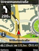
Nokia presented a new version of its Nokia Maps navigation service at the Mobile World Congress in Barcelona. This service is geared toward pedestrians and will be available on the Nokia 6210 Navigator phone: Nokia Maps 2.0 adds Walk, a pedestrian focused navigation component to the application, while still offering Drive, a world class car navigation system. The pedestrian navigation efficiently walks you from A to B with visual turn-by-turn guidance. It helps you to locate yourself by giving information about the surrounding buildings, streets and parks (including pathways through the park) and in newer handsets, like the Nokia 6210 Navigator, points the direction in which you are walking; using the handset's built in compass for orientation.
The new Nokia Maps 2.0 update also adds the option to purchase first-class multimedia guides that feature photos, videos and audio streams to enlighten your journey even more. As with the previous version of Nokia Maps, map users will receive a free 3-day Navigation trial, for Walk and Drive, plus an additional free 10 minute City Guide trial.
"By taking navigation services out of the car and onto the sidewalk, Nokia is enabling people to explore and discover what's around them with the confidence of a local," said Michael Halbherr, vice president, Nokia location based services. "By combining the integrated compass of the Nokia 6210 Navigator, with the speed and accuracy of assisted GPS, Nokia Maps 2.0 provides a unique experience with which other less accurate mobile navigation applications can't compete."
Upgrading to the GPS navigation option enables your mobile to become a powerful connected personal navigation device, that provides clear, turn-by-turn visual and voice guidance. If your Nokia device doesn't have built-in GPS, you can also use an external GPS module with a compatible device. Nokia Maps 2.0 will also have, for an optional fee, real-time traffic feeds with dynamic re-routing in 18 European countries. With vector maps provided by TeleAtlas and Navteq, Nokia Maps now has maps covering over 200 countries, with over 70 of them navigable.
Nokia Maps 2.0 can also lead you to the nearest transit station using localized icons in 17 cities so you can hop on the Metro to get across town. While you are on riding on the Metro you can discover and explore new places using the hybrid satellite views or by purchasing one of the new multimedia city guides from companies like Berlitz. The expert advice on where to go and what to do, combined with the integrated Nokia mobile search, helps Nokia fulfill its goal of bringing people context aware Internet services forward.
A beta version of the software can be downloaded over here.


No comments:
Post a Comment