Wednesday, June 06, 2007

TomTom Map Share Technology


location based services

06 giugno 2007


TomTom today announced the introduction of TomTom Map Share on the new TomTom GO 520 and TomTom GO 720. This unique new map improvement technology allows TomTom users to easily improve their maps as soon as they spot changes in the roads with a few touches on the screen of their device. Via TomTom HOME, TomTom Map Share users also receive all map improvements made by others, making their maps as dynamic as the world they live in.
TomTom Map Share is a proprietary map improvement technology unique to TomTom, which enables users to easily and instantly improve maps. TomTom users can respond in real time to changes in the road network and correct the maps on their TomTom devices accordingly. Thanks

to the Smart user interface, it is easy to make improvements, such as blocked or unblocked streets, reversed one way traffic or new street names, which will instantly take effect.
Roads are continually changing. This feature gives TomTom users the option to capture these changes on their device in-between map releases and keep their data as current as they wish. These changes allow the community of TomTom Map Share users to always have the most up-to-date maps and inside local knowledge at their fingertips.
TomTom has the world's largest satellite navigation community with over 10 million users. TomTom Map Share users can share their improvements with each other easily through TomTom HOME, TomTom's free software application that enables users to manage, download, store and transfer content from their computer (PC/MAC) onto their TomTom device. When it comes to sharing improvements, users can choose between downloading all reported map improvements or only accepting map improvements verified by a TomTom team of experts to guarantee timeliness and validity.
TomTom Map Share is offered for free with both the TomTom GO 520 and TomTom GO 720. "TomTom Map Share is an important component of a new era in navigation. By enabling millions of TomTom users around the world to automatically share and mutually benefit from each other's local road knowledge every day for free, TomTom ensures that drivers have the most accurate and up to date maps available in the industry", said Harold Goddijn, chief executive officer at TomTom.

Print version Send to a friend Write your comment »
GeoVector and CyberMap Japan Enhance the World’s First Pointing Based Local Search Solution for Mobile Phones

location based services

SAN FRANCISCO--(BUSINESS WIRE)--GeoVector Corporation:
Mapion Pointing Application Release 2.0, powered by GeoVector, offers new mobile local search capabilities including first of its kind user driven, opt-in advertising, sponsored categories and preferred placement.
Innovative, intuitive pointing interface to information on 700,000 Points of Interest across Japan now available on over 2 million Sony Ericsson, Kyocera and Casio mobile phones using the KDDI network.
GeoVector Corporation, the leader in pointing based search solutions, and CyberMap Japan Corp., owner of mapping services leader Mapion, today launched Mapion Pointing Application 2.0, called Mapion Pointing Appli, for mobile phones in Japan. This upgrade transforms Mapion’s existing GeoVector pointing mobile search service into a fully commercial application available to over 2 million phones.
Mapion Pointing Application is an exciting tool that allows users to easily find and launch rich content by pointing and clicking mobile phones at retailers, restaurants, historical sites or any of Mapion’s 700,000 Points of Interest (POI) across Japan. The service combines Mapion’s POI data with GeoVector’s pointing based technology and spatial search engine, providing the world’s first truly personal local search.
The new release builds upon the success of Version 1.0, user feedback and solid experience, greatly improving functionality and ease of use. New capabilities include user driven opt-in advertising, sponsored categories and preferred placement.
“These upgrades greatly improve our mobile local search capabilities, giving users the information they need, wherever they need it most,” explained John Ellenby, President of GeoVector. “Users and advertisers can now connect based on the user’s interests, without the exchange of any personal information.”
“Mapion is always searching for pioneering technologies to improve our user experience,” said Takehiko Murata, President of CyberMap Corp. Japan. “GeoVector’s exciting technology allows us to bring users an experience available nowhere else in the world, giving us a significant advantage over our competitors.”
“Soon people will pick up any GeoVector capable mobile device and merely point it at something to access a wide variety of rich content,” added Ellenby. "While a computer and mouse help you to surf the world wide web, GeoVector enables you to Surf the Whole Wide WorldTM just by pointing your mobile phone."
The service was initially launched over the KDDI network in January of 2006 and is now available for download with Sony Ericsson models W32S, W41S, W44S and W51S phones, the W41K by Kyocera, the W42CA by Casio and, in July, the W52S from Sony Ericsson.
About GeoVector Corporation
Headquartered in San Francisco, CA, GeoVector develops solutions for location-based services and tools for wireless communications manufacturers, wireless service providers and mobile content developers. Supported by significant intellectual property, GeoVector’s spatial search engine technology provides the foundation for new community, gaming, advertising and other location sensitive applications. GeoVector allows mobile web services to be attached to any object or location and launched just by pointing at them with a mobile device. This includes Point to Call® services for one click calling and Point to Buy® M-commerce transactions. Please visit http://www.geovector.com.
About Mapion
Headquartered in Tokyo, Japan, CyberMap Japan Corp.’s Mapion service has over 700,000 page views per day and is Japan’s leading mapping search service. With over 200 enterprise customers including Starbucks, ANA, Ford, NEC and Panasonic, Mapion is also Japan’s leading mapping ASP service. Mapion’s nationwide service in Japan is ubiquitous across PCs, PDAs and all of Japan’s mobile phone operators. Mapion’s shareholders include Toppan, NTT Communications, Dentsu, Yahoo! Japan and Sharp.
Google and the Geoweb

location based services

Bent Hagemark, Lior Ron, Michael Jones
Do you want to reach the largest possible audience, in the most innovative ways, with your geospatial data? If so, then KML is the answer. KML is a file format used to display geographic data in a geo-browser, such as Google Earth, Google Maps, and Google Maps for mobile. We'll give you a tour of what is possible in KML and show you how to create your own custom map layers. We'll also talk about how you can help Google to index your geospatial content (KML, GeoRSS and more) so that we can send more search traffic your way.
Speaker Bio: Bent joined Google in January 2006 and is a software engineer working on KML and KML tools. Previous to Google Bent worked at Opera Software and Silicon Graphics.Lior is the Product Manager for geo search in Google, where he is trying to help the world around us get mapped using the power of the masses. Before joining Google, Lior co-founded a medical device and a search startup, and served in various managerial positions in the Israeli Intelligence, where he worked on GIS and search problems. Lior holds an MBA from Stanford and BSc and MS from the Technion - the Israeli institute for technology.Michael Jones is Chief Technology Officer of the Google Earth service for distributed geospatial visualization to users worldwide. He is co-founder of Keyhole, the company taken over by Google to create Google Earth. In addition, he is a popular technical presenter, an inventor with eleven issued U.S. patents, a director on private company boards, and an associate in several Silicon Valley projects. He was formerly President & CEO of Intrinsic Graphics, Director of Advanced Graphics Software at Silicon Graphics responsible for OpenGL, Performer, and all other graphics APIs, co-founder of a movie coloring company, and a computer graphics consultant during the 1980s. He has been a computer programmer since the fourth grade.
Video: watch this session

Tuesday, June 05, 2007

Google Maps API Introduction

location based services

Brandon Badger
The Google Maps API is a powerful way to put a custom map on your website. In this session, you'll learn just how easy it is to create your own maps mashup. We'll start with the basics and progress through the tools that the API provides. By the end of the session, you'll be amazed at the sophisticated maps that you'll be able to embed on your web site with just a few lines of JavaScript.
Speaker Bio: Brandon is the Product Manager for the Google Maps API and KML. While at Google, he has worked to grow the Google Maps and Google Earth development communities. Prior to Google, Brandon worked as an Engineer and Development Manager at Symantec. He holds an MS in Computer Science from Stanford University. As an Undergraduate, he played on the NCAA champion Stanford tennis team and earned a BA in Economics.
Video: watch this session
Xionetic Locator Web of Bozeman, Montana to Power TomTom's Retail Locator

location based services


June 5, 2007
View for printing
Xionetic Technologies, a leading developer of advanced location-based services software announces that TomTom, the world's largest portable navigation solutions provider, has selected Xionetic Locator Web to power their store locator -- the "where-to-buy" functionality on their website.
TomTom chose to implement Xionetic Locator Web as a result of the rapid growth in the number and diversity of North American retail outlets. The program enables TomTom customers and web visitors to search more than 18,000 retailers in the TomTom database to easily and quickly find pertinent store information nearest them, including store locations, hours and phone numbers.
Xionetic Locator Web is an advanced location-based search engine that allows you to easily add a store locator and customizable mapping and driving direction functionality to a web site. Almost 200 companies use Xionetic Locator Web to provide their web visitors with detailed information on where to buy their products or services.
"We are pleased TomTom has chosen to use Xionetic Locator Web," says Sarah Savage, Product Marketing Manager at Xionetic. "TomTom is the world's largest provider of portable navigation solutions, and they understand the value of providing up-to-date location and direction services on their website."
About Xionetic:
Xionetic Technologies, Inc. specializes in building and managing location based searching applications and advanced electronic marketplace software. Over 6,000 commercial and public sector customers use Xionetic's suite of geographic locator and business analytics applications. Founded in 1991, Xionetic Technologies is a privately held company based in Bozeman,Montana.
Xionetic Contact:
Sarah Savage
Telephone: 406-556-0212
Email: Sarah.Savage@xionetic.com
http://www.xionetic.com
About TomTom:
TomTom NV is the world's largest portable navigation solutions provider. TomTom's products are developed with an emphasis on innovation, quality, ease of use and value. TomTom's products include all-in-one navigation devices which enable customers to navigate right out of the box; these are the award-winning TomTom GO family, the TomTom ONE range and the TomTom RIDER. TomTom was founded in 1991 in Amsterdam and has offices in Europe, North America and Asia Pacific. TomTom is listed at Euronext, Amsterdam Stock Exchange in The Netherlands. For more information, go to http://www.tomtom.com.
TomTom Contact
Google Maps Gains Transit Info

location based services


In some cities and for some types of public transportation, Google Maps can show the next departure time, what lines serve a specific station, and a link to the transit agency.
By Thomas Claburn InformationWeek Jun 5, 2007 02:00 PM
Google Maps gained a new feature Monday: The transit station icons on Google Maps now present transit information when clicked.
"Depending on the data available for a given public transit system, Google Maps now shows the next departure times, what lines serve a specific station, and/or a link to the transit agency to get more detail," said Christoph Oehler, a product manager at Google, in a blog post.
Some stations show departure times; others show only links to the associated transit service.
For a limited number of cities, Google-assisted travelers can generate detailed trip plans on public transit using Google Transit Trip Planner, an experimental Google Labs service that works in conjunction with Google Maps.
Google Transit Trip Planner covers the following states, cities, and transit agencies: Burbank (Burbank Bus), Orange County (OCTA), and San Diego (MTS), Calif.; Tampa (HART), Fla.; Honolulu (TheBus); Pittsburgh (Port Authority); Duluth (Duluth Transit), Minn.; Reno (RTC RIDE), Nev.; Eugene (Lane Transit District) and Portland (TriMet), Ore.; Austin (Capital Metro), Texas; and Seattle (King County Metro).
The service also covers national rail networks, domestic airlines, and ferries in Japan.
Google depends on transit data supplied by transit agencies. It provides details about how to submit transit data at its Web site.

Search Is Driving Mobile Web Growth In The U.S

location based services


.Posted by Stephen Wellman, Jun 5, 2007 04:30 PM
Use of the mobile Web in the U.S. continues to grow, despite all the criticisms from bloggers and wireless insiders. According to the latest findings, the U.S. is now second only to the U.K. in terms of mobile Web use. What's driving all this growth?
According to Bango (the company that released the findings -- yes, I know they're a mobile content vendor, but bear with me), it's mobile search. So much for mobile search being an emerging category. Here is a recap of Bango's findings*:
The top five countries accessing the mobile web via Bango in April 2007 were the UK at 27%, the US at 21%, South Africa at 11%, India at 9% and Indonesia at 3%. In total, Bango detects mobile web users from over 190 countries.
And where is the future of the mobile Web? The BRIC, of course. Of the big four India is showing amazing growth:
In addition to growth in the US, Bango's data shows that 9% of all accesses to mobile websites now come from India, up from 4% a year ago. India, with a population of just over 1.1 billion and lack of an established fixed phone line network, relies on mobile phones to stay in touch. Here, mobile phone usage is set to exceed European levels within the next few years.
That also means India will likely exceed the U.S. and may become the definitive market for the mobile Web.
And which phones are people using to surf the mobile Web?
In the first quarter of 2007 the top handset for accessing mobile websites was the Sanyo Katana SCP 6600. The fact that the Sanyo Katana is only available in the US reflects the rapid growth in mobile surfing by US users. Other popular handsets included the Motorola RAZR V3, the Sony Ericsson K750i and the Samsung A900.
Besides mobile search, what else is prompting people to use the mobile Web? It's flat-rate data:
"We see that wherever flat-rate mobile data charges are pervasive in a country then there's much more web browsing," said Anil Malhotra, SVP of Marketing at Bango. "This is certainly true of the US and South Africa and the imminent introduction of flat-rate data charges in the UK will push up mobile web usage in the UK even further."
The findings from this Bango report echo a blog post of mine from earlier this year. That survey, from the Online Publishing Association, targeted a roughly equal number of respondents in the United States, the United Kingdom, France, Italy, Germany, and Spain. It found more mobile users in the U.S. than in Europe. And, just like the Bango numbers, the OPA study claimed that the U.S. was second only to the U.K. in terms of total mobile Web use.
What do you think? Will the U.S. overtake the U.K. in terms of mobile Web use? And how long will it take India and China to overtake both?
* "Bango identifies users by their country and network of origin. The ranking is produced by measuring the number of user visits to mobile websites from each country."
« Apple MacBook Pro Laptops Push Santa Rosa Platform Main A One-Day Lesson In Telepresence Basics »
SiRFDiRect Location Technology Delivers Portable Navigation Breakthrough

SiRF Technology Holdings, Inc. , a leading provider of GPS-enabled silicon and premium software location platforms, today introduced its SiRFDiRect(TM) technology, a portable navigation breakthrough that achieves navigation accuracy and coverage previously available only in costly, permanently installed in-car systems. Employing sophisticated algorithms that take advantage of closely coupled GPS and dead-reckoning (DR) sensor measurements, SiRFDiRect technology delivers very high quality positioning, even in the worst GPS signal conditions, without the installation inconvenience and high cost of traditional in-dash navigation systems. The first implementation of SiRFDiRect technology integrates the award-winning SiRFstarIII(R) architecture with low-cost heading and acceleration sensors to give portable devices continuous and accurate navigation capabilities typically found in very high-end in-car navigation systems. "As the portable navigation devices are starting to address mainstream, it is very important to meet consumer expectations of reliable positioning everywhere, no matter what, and our SiRFDiRect technology is a major advance in that direction," said Kanwar Chadha, founder and vice president of marketing for SiRF. "It gives our portable navigation device customers a competitive edge by enabling them to provide in-car system navigation accuracy at lower cost while retaining the advantages of portability and transferability." SiRFDiRect technology uses heading and acceleration data from the sensors to boost the accuracy of portable navigation systems when GPS signals are weak or blocked, such as in dense urban canyons and tunnels. Transitions between combined GPS/DR and dead-reckoning-only operation are seamless and accurate without operator intervention, and the closely coupled GPS/DR architecture of SiRFDiRect technology continuously auto-calibrates the heading and acceleration sensors, enabling high performance with low-cost, small-footprint sensors. The sensors can be located in the portable device or in an external dashboard mounting cradle. Further enhancing ease of use, SiRFDiRect technology allows great flexibility in orienting portable navigation devices when mounting them in a vehicle without affecting performance. Mio Technology, Ltd., a leading maker of portable navigation devices, announces its plans to deploy SiRFDiRect based Navsteadi(TM) high-precision navigation technology at Computex Taipei 2007 (TICC/Hall 4, Booth 101B). Navsteadi (TM) brings in-dash like positioning accuracy and reliability to portable navigation systems. "The new technology co-worked by SiRF and Mio, gives our customers the best of both worlds; reliable performance in the most challenging GPS conditions, expected of the typical high-end navigation system, while maintaining the traditional cost and portability advantages of Mio systems," said Samuel Wang, president of Mio Technology Ltd. "Our continuous close alliance with SiRF has enabled us to bring leading edge products with innovative technologies quickly to market, to enhance the user experience of portable navigation devices." Availability SiRFDiRect technology is part of SiRF's portfolio of premium software offerings. SiRFDiRect technology and complete reference designs will be available in the third quarter of 2007 with the GSC3e/LP and GSC3f/LP chip sets, and will be migrated to future SiRF hardware platforms. About SiRF Technology Holdings, Inc. SiRF Technology Holdings, Inc. develops and markets semiconductor and software products that are designed to enable location-awareness utilizing GPS and other location technologies, enhanced by wireless connectivity capabilities such as Bluetooth, for high-volume mobile consumer devices and commercial applications. SiRF's technology has been integrated into mobile consumer devices such as automobile navigation systems, mobile phones, PDAs, GPS-based peripherals and handheld GPS navigation devices, and into commercial applications such as location servers, asset tracking devices and fleet management systems. SiRF markets and sells its products in three target platforms: wireless handheld devices, such as mobile phones; automotive electronics systems, including navigation and telematics systems; and consumer and compute devices, including personal digital assistants, notebook computers, recreational GPS handhelds, mobile gaming machines, digital cameras and watches. Founded in 1995, SiRF is headquartered in San Jose, Calif., and has sales offices, design centers and research facilities around the world. The company trades on the Nasdaq Stock Exchange under the symbol SIRF. Additional information about SiRF and its location technology solutions can be found at http://www.sirf.com/.
Search WirelessDevNet for Related Items
NAVTEQ to Present at Bear Stearns Technology/Communications/Internet Conference


(NYSE: NVT), a leading global provider of digital map data for vehicle navigation and location-based solutions, announced today it will present at the Bear Stearns Technology/Communications/Internet Conference on June 12, 2007. David Mullen, Executive Vice President and Chief Financial Officer, will speak at 2:45PM EDT. Investors are invited to listen to a webcast of the presentation by accessing http://www.navteq.com, clicking on "Investor Relations," and then clicking on the webcast icon. For those who are unable to listen at the time of the presentation, an archive of the webcast will be available on the company's website for 30 days following the presentation.About NAVTEQ NAVTEQ is a leading provider of comprehensive digital map information for automotive navigation systems, mobile navigation devices, Internet-based mapping applications, and government and business solutions. NAVTEQ creates the digital maps and map content that power navigation and location-based services solutions around the world. The Chicago-based company was founded in 1985 and has approximately 2,800 employees located in 167 offices in 28 countries.
High Performance GPS Solutions in New Generation of Handheld Devices

location based services

Wonde Proud Chooses NemeriX for Next Generation GPS ProductsMANNO, Switzerland-/Wi-Fi Technology News/- NemeriX, a leading fabless semiconductor company specialising in ultra low power semiconductors and solutions for GPS and location-based service devices, announced today that Taiwan-based OEM Wonde Proud Technology has selected NemeriX for its new generation of GPS personal navigation devices.
The latest NemeriX solutions will be integrated into a range of Wonde Proud Personal Navigation Device (PND) ‘mice’ – so-called because they look much like a computer mouse. NemeriX technology is already built into four models currently available in the UK under the brands of Holux, OnNext and Polaris. European brands include Adapt, XAIOX and Oasis-Media. Depending on user preferences, handheld devices can receive location-based services from ‘push’ or ‘pull’ providers. ‘Push’ providers broadcast information to PNDs of users who have elected to receive information from providers relevant to their personal interests – for example film theatres, Chinese restaurants, and jazz clubs. A ‘pull’ location-based service provider makes their information available to anyone who seeks to ‘pull down’ (download) services from their PND.Wonde Proud’s Director Marketing Mark Hu said, “We chose NemeriX technology due to its superior low-power performance, high sensitivity and reliability. NemeriX’s solutions are already in our CD100, CD110, BT77 and BT55 models, so this agreement marks a further strengthening of our partnership.”“We will also integrate NemeriX technology into our new models including the BT100X, CD150 camera detector, CD160 data logger, VT100 vehicle tracker plus NJ2020 later this year. We expect to produce up to 600,000 pieces in 2007.” NemeriX VP of Marketing Lew Boore, said, “NemeriX is focused on the delivery of low-power, high-performance GPS and A-GPS solutions that allow our customers to differentiate themselves, as well as provide consumers with the best user experience. We are proud to have Wonde Proud as a key partner.”A number of organisations connected with the 2008 Beijing Olympics are said to be interested in Wonde Proud PND devices. Four models are already on sale in China under local brands.With the new generation of PNDs, people will be able to more rapidly and accurately pinpoint their position and request location-based services. These may be business facilities such as the nearest train station or WiFi-enabled café or a more personal benefit such as the nearest hairdresser or date-matching service. About Wonde Proud:Wonde Proud Technology is specialized in GPS navigation devices and CCTV surveillance equipment. Wonde Proud Technology has been one of the leading manufacturers of video processing of RF modulation and A/V transmission systems in Taiwan. With 12-years experience, highly competitive R&D team Wonde Proud Technology are now introducing the Wonde X GPS series into the existing navigation market. In addition, Wonde Proud Technology offers OEM/ODM services upon request. To find out more about Wonde Proud Technology, please visit http://www.wondeproud.com.About NemeriX:Founded in April 2002, NemeriX S.A. (Manno, Switzerland) is a venture-backed fables semiconductor company specialising in ultra low power GPS and LBS integrated circuits, software and firmware for GPS and wireless applications. NemeriX’s devices enable battery-power location determination anywhere, anytime, facilitating the design and manufacture of truly differentiated products for both consumer and professional markets. For more information about NemeriX, please visit http://www.nemerix.com.

Monday, June 04, 2007

Location-Based Services: A Primer

LBS encompass all applications that rely on position information in a mobile context, from basic 911 subscriber calls, to personal navigation, in-vehicle telematics or commercial asset tracking. In most instances, the ability to quickly and accurately calculate a position is paramount to customer satisfaction and revenue potential.
Legacy Positioning Techniques IssuesEver wondered what happens when you call 911 on your mobile? A few years ago, several regulatory agencies worldwide, including the US and the FCC’s E911 program, mandated mobile operators be able to relay a subscriber’s position to emergency response personnel. Until recently, the accuracy of these positions, approximated from nearby cell sites, remained of the order of a city-block in urban centers, but could be several kilometers off in rural settings or along highways. Operator compliance remained low as no valuable commercial services could be derived from infrastructure investments required in these legacy techniques.
Assisted-GPS—The New StandardGPS technology already enables cost-effective, street-corner position accuracy. Conventional GPS technologies however do not meet LBS requirements given potentially long initial position calculation delay, ongoing battery consumption and poor “in-building” performance. Assisted-GPS represents an evolution of GPS that relies on rough position information readily available from the network at no cost (i.e. the nearest cell site) and the ability to then download useful data to the handset to help it quickly determine its position. AGPS chips consume very little battery power and yield quick and accurate location information. This helps operator meet their regulatory requirements and enables them to deploy more valuable applications from which additional subscriber revenues can be derived.
Apple iPhone - Did they forget about the location sensor?

location based services

I watched Steve Job's introduction of the new Apple iPhone. It truly looks revolutionary, but I could not find within any of the tech specs about a location sensor: No GPS chip. Yes, you can view maps...there's an icon to link to Google Maps via a Wi-Fi connector; sure you can see imagery as well which is nicely displayed on the very wide screen interface. But unless you can load something like Skyhook's location finder device that uses Wi-Fi, accurate positioning seems to have been left off the list of important features. Am I wrong; has anyone seen differently. So, there is no inherent LBS function that automatically identifies your location then routes you from your position to wherever.


Posted by Joe Francica in LBS at 11:26 Comments (8)


-->


Trackbacks

Trackback specific URI for this entry


No Trackbacks

-->

Comments
Display comments as (Linear Threaded)
Joe - no, you’re not wrong - you got it right. Apple’s lack of a handset-resident location capability is not that surprising though given they have chosen the GSM route with Cingular. The GSM world hasn’t yet solved GPS on the chipsets on a large scale like the CDMA and IDEN world has, but the emerging Secure User Plane Standard that GSM will use will help with that over time.
#1 Jon Spinney (Link) on 2007-01-10 12:38 (Reply)
What about the FCC mandate? Does this mean a fine and/or action by the Feds because they built a non-compliant device?
#2 Archie Belaney on 2007-01-10 13:20 (Reply)
Wait a minute...maybe Apple's finally noticed something.The truly vast proportion of people who own phones and personal digital devices know pretty much right where they are. Contrary to the experience of globe-trotting, plane-hopping new-age marketeers and sales people, Most people don't travel all that much outside their home towm or local area. So a GPS to "find yourself" on a map is irrelevant. Because as Josie Average, you know where you are. If you don't, it's because you're on the other side of town and looking for a new store, restaurant, or whatever. If that's the case, you look at a map. Which is what Apple's betting on here...the user interface is simple, Google is simple, and the idea of "placing yourself in context on the map" is pretty simple, too. Most folks can read a street sign, or in a general way figure out where they are on a Google-toon. So has Apple made the simplest location-enabled device yet...an actual MAP-CENTRIC device? Hmmmmm.I wonder if the utility of GPS is rendered irrelevant by the simple idea of someone navigating by looking at a map or an aerial photo? Imaging that, looking at a map to figure out where you are. You know, that just might work.Still doesn't solve the whole e-911 thing, but maybe that's for a future edition.
#3 Archie Belaney on 2007-01-10 13:38 (Reply)
During the address at MacWorld, Jobs said about the iPhone, "The way to bring the real internet to your phone". "Now, I want to show you something truly remarkable: Google Maps on iPod." The audience "oogled". I can't be impressed unless the phone provides location determination automatically. Despite the outstanding user interface of the phone, I'll still need to type in my existing address first before any routing can occur. If it was truly map-centric, it would place the phone owner at the center of the map first upon turning on the phone. Jobs made reference to the phone's 3 sensors...one that turned off the screen as the user placed the phone up to your ear to conserve batteries...that in itself was very cool. I was waiting for him to talk about the "location sensor". I guess I'll have to live with disappointment. Maybe version 2.
#3.1 Joe Francica (Link) on 2007-01-10 15:19 (Reply)
For GPS enabled phones checkout Nokia's N95. Comes with a 5MP camera to boot. Not sure about a Symbian OS though.
#4 Shane Ring on 2007-01-10 14:59 (Reply)
I agree many people would not need GPS, but admit for business it is great aid. Since many of us work for companies that use GPS to improve productivity, I would have at least figured this would be a add-on.
#5 Glenn Graham (Link) on 2007-01-11 09:52 (Reply)
A more base and probably realistic backgrounder on the lack of GPS...cameras and movies and music sells. Nobody's paying for location.Couple that (what more do you need, actually) with the battery suck of a GPS and the low adoption rate, and the mandate just ain't there.Kudos to Apple for being honest with the state of technology.
#6 Archie Belaney on 2007-01-13 22:59 (Reply)
I agree that outside of corporate America, GPS in a phone is not selling a lot of units. Since Apple is not selling the iphone outside the US initially, I am hoping however that they will offer it in the iphone by the time they sell it internationally. I'm American but currently living in the Philippines. And here, it can be very hard to find your way around. Not just for someone like me who has only been her for 4 months either. I know Filipinos who have lived in Cebu for years and don't know how to get many places simply because many streets here, although named, don't have street signs. Also many buildings don't have addresses on them. (They have addresses, of course, but they aren't labeled!) This is not uncommon for a developing country and a functional GPS device with useful data (especially breadcrumbing GPS software so I could at least find my way back!) and a way for me to continually add my own data.
#6.1 Robert on 2007-06-04 11:07 (Reply)
Add Comment

Sunday, June 03, 2007

Add Driving Directions and Traffic to your Google Maps Mashup!


location based services


Last week during the 2007 Google Developer Day the Google Maps API Team reviewed and introduced a number of significant new enhancements for the Google Maps API. This will help those of you creating Google Maps mashups to improve your mashups with support for things like driving directions and live traffic overlays.Driving Directions - No more linking off to Google Maps for driving directions on your mashup. The Google Maps API now supports driving directions so you can include this great Google Maps feature right in your mashup or tool! Google's Yatin Chawathe explains it best in this Google Maps API Blog post: "..The simplest way to add driving directions to your page is to create a map, create a DIV for the directions panel, attach both of them to the new GDirections object, and fire off a query to it!" This blog post will give you the steps and sample code to get this going, and there is also a new section to the Google Maps API Documentation that will help you as well.Live Traffic Conditions Overlay - Want to show present traffic conditions on your Google Maps mashup? Import the same traffic monitoring available on Google Maps for several US cities into your Google Maps API site by following the steps laid out in the new Traffic section of the Google Maps API Docs.Also new and updated in the Google Maps API:Create image overlays with GGroundOverlay & GGeoXML (Documentation here..)Usage of the Marker ManagerGoogle Maps API geocoder updatedSyndicate your Google Maps mashup with a "Google Mapplet"Google Maps API New Features Presentation - Take a look at this presentation by Google's Doug Ricket that should help you out with sample code that puts all these new features to use in your Google Maps API site..__________Technorati Tags: GDD07,
Trimble VRS Now Service Launched in Colorado for High Precision GNSS

location based services


SUNNYVALE, Calif., June 1 -- Trimble announced today that it has launched its Trimble(R) VRS Now(TM) service in Colorado across Denver's Front Range. The commercial subscription service will provide surveyors, civil engineers and geospatial professionals, with instant access to real-time kinematic (RTK) positioning corrections without the need for a field base station.The service will deliver centimetre-level RTK and differential GPS (DGPS) positioning customized for each Global Navigation Satellite System (GNSS) rover receiver's exact location anywhere in the network. The Trimble VRS Now service will supply fast, easy to use and accurate GNSS positioning for a variety of applications including surveying, urban planning, construction, transportation, environmental monitoring, resource and territory management, disaster prevention and relief, weather services and scientific research.In addition to standard cell phone connection to the network, service in Colorado also includes an innovative and powerful radio broadcast option. The radio option provides further assurance to users, even in areas where cellular signals are limited."Our Colorado network is the third commercial GNSS infrastructure service offering from Trimble. Because of the high rate of growth in and around Denver, Trimble VRS Now provides real business value to the local community," said Jurgen Kliem, general manager for Trimble's Survey Division. "Our goal is to streamline the work of surveying businesses and increase productivity by enhancing the synergies among tools, techniques, services and relationships, which build a Connected Site."The system in Colorado includes a network of Trimble NetR5(TM) GNSS Reference Stations equipped to receive broad-spectrum GPS and GLONASS positioning signals to maximize field productivity. Network corrections are calculated using Trimble VRS(TM) technology, the most widely-used network RTK solution worldwide. Covering approximately 2,300 square miles (3,701 square kilometers), users connect into the network using a wireless connection-either cellular or radio-for fast, easy access to precise network RTK and DGPS corrections.Trimble VRS Now represents a major advance in precision surveying productivity. No longer dependant on a field base station, precision GNSS surveys are easy to perform and users can be up and running in minutes. And without the need for base station hardware, all of a user's GNSS receivers can now work independently as rovers-saving time and money. Simply connect, correct and measure.A subscription to Trimble VRS Now service and a GNSS rover is all a user needs to begin surveying or collecting data with precision anywhere within the network. Surveyors and other users can switch on their receiver and real-time corrections are available in seconds. Trimble VRS Now works with nearly all GPS and Global Navigation Satellite System (GNSS) survey instruments from a variety of manufacturers. For more information visit: http://www.trimble.com/VRSNow.shtml . The Connected SiteTrimble's Connected Site model creates seamless working relationships among Trimble products, technologies and services through support, infrastructure and partnerships. Taking Integrated Surveying(TM) to the next level, the Connected Survey Site enables surveyors to choose from a broad range of options, including surveying techniques, communications channels and facilitating services such as GNSS infrastructure in one fully-integrated and interoperable surveying solution. Surveyors benefit from complete data compatibility with Trimble field and office software; increased flexibility in employing the best tools and techniques for the job at hand; the adaptation of specialized technologies to fit the ideal workflow of surveyors; and the localization of surveying solutions to address specific market needs throughout the world.About Trimble's Engineering and Construction BusinessTrimble, a world leader in GNSS, construction lasers, robotic total stations and machine control solutions, is creating a broad range of innovative solutions that change the way construction work is done. The Engineering and Construction business of Trimble is focusing on the development of technology and solutions in the core areas of surveying, construction and infrastructure. From concept to completion, Trimble's integrated systems streamline jobs and improve productivity.About TrimbleTrimble applies technology to make field and mobile workers in businesses and government significantly more productive. Solutions are focused on applications requiring position or location-including surveying, construction, agriculture, fleet and asset management, public safety and mapping. In addition to utilizing positioning technologies, such as GPS, lasers and optics, Trimble solutions may include software content specific to the needs of the user. Wireless technologies are utilized to deliver the solution to the user and to ensure a tight coupling of the field and the back office. Founded in 1978 and headquartered in Sunnyvale, Calif., Trimble has a worldwide presence with more than 3,400 employees in over 18 countries.For more information, visit: http://www.trimble.com
Search WirelessDevNet for Related Items
Mapping That Puts You There

location based services

By Rob PegoraroThursday, May 31, 2007; Page D01
In one window on my computer, I'm strolling down the Embarcadero in San Francisco -- but instead of sticking to the sidewalk, I'm somehow occupying the middle of the southbound lanes, where I've been passed by a series of sport-utility vehicles.
In another browser window, I'm flying over a slightly blurry version of Lower Manhattan. I can see the park near my cousin's old apartment, but I can't spot the pizza joint or the bagel store that should be there. Then again, I can get uptown much faster than usual, since I'm no longer confined to the streets or the subway.

Microsoft's Live Search Maps has added New York to its 3-D flyover options.
Transcript
Personal TechThe Washington Post's Rob Pegoraro discusses his recent reviews and answers your personal tech questions.
Faster Forward -- Tech Blog
Personal technology columnist Rob Pegoraro blogs about gadgets, software, tech glitches and more. • So This Is What Palm's Been Up ToWeb Mapping Options MultiplyApple TV: Now Safe To Buy? Sign Up for RSS FeedFaster Forward ArchiveFast Forward ColumnsLive Q & A's
Weekly Podcast


one window on my computer, I\'m strolling down the Embarcadero in San Francisco -- but instead of sticking to the sidewalk, I\'m somehow occupying the middle of the southbound lanes, where I\'ve been passed by a series of sport-utility vehicles.','Rob Pegoraro') ;
document.write( technorati.getDisplaySidebar() );
Who's Blogging?
Read what bloggers are saying about this article.
Monstropolis - Monstrositaeten des Alltags
Trylon SMR - Public Relations focused on New Media and Technology
Citizens Band
#technorati_link a {color:#339900;}
Full List of Blogs (8 links) »
Most Blogged About Articles
#technorati_link a {color:#339900;}
On washingtonpost.com On the web
Save & Share Article
What's This?
Digg
Google
del.icio.us
Yahoo!
Reddit
Facebook
Online mapping has advanced a little since the days when everybody was excited just to see Web sites that could calculate driving directions for us.
Now, mapping sites include extras like satellite photography, real-time traffic data and outlines of buildings. They even act like regular desktop programs, allowing you to scroll around and zoom in with a keyboard or mouse -- no need to wait for a page to reload.
This week, the operators of the two best mapping sites -- Google and Microsoft-- upgraded their mapping sites in flashy, useful ways.
Google Maps ( http://maps.google.com/) now provides a "Street View" option -- pavement-level perspectives of Denver, Las Vegas, Miami, New York and San Francisco. Microsoft's Live Search Maps ( http://maps.live.com/), meanwhile, has expanded the list of cities in which it provides three-dimensional flyover views to include New York and other U.S. and international locales, such as Austin and Ottawa.
These options are not quite new. Google's Google Earth program offers its own 3-D flyovers, though without the high resolution of Microsoft's service. Amazon's A9 search site provided a sidewalk-view option years ago, and Microsoft has a version of that concept tucked away on a corner of its own site ( http://preview.local.live.com/).
But now you don't need to bookmark a new site or run a separate program. You can open your Web browser to a mapping site you already know and start clicking away.
Google Maps' Street View doesn't require any extra software; it worked in the Internet Explorer, Firefox and Safari browsers. If this option is available in the area you're viewing, a "Street View" button will appear. Click it, and any streets with available photography will appear outlined in blue. Then drag a stick-figure icon to the street you want to inspect.
The Street View vista appears in a little frame over the standard Google Map view. You can pan around the view or zoom in just by scrolling or double-clicking. Then, wander through the city by clicking the arrow icons that float over each street.
It may remind you of navigating through old interactive-adventure games like Myst, except all this runs inside your Web browser, not a CD-ROM's worth of separate software.
Street View photos sometimes had the washed-out look of camera-phone pictures but still yielded an extraordinary level of detail -- I couldn't read headlines in newspaper vending boxes, but I could easily make out the license plates of cars on the streets.

Friday, June 01, 2007

Map Wars: Google and Microsoft Tussle Over Coolest Map Apps


location based services

Where_20 At the Where 2.0 conference in San Jose--which, like every other web-related conference these days, is jammed. "Geospatial" content and tool companies have developed into their own micro-economy, and Where is the center of it.

The big fight, here as elsewhere, is between Google and Microsoft, over who can produce the coolest 2D and 3D global mapping platforms. The startling news is that, in this arena, Microsoft appears to be holding its own. Google's new "block view" feature is cool (put yourself on map, look at buildings around you, walk down street, etc.), but Microsoft's new "Virtual Earth" project is even cooler. The latter is powered by high-res photos taken from low-flying planes, and the reported $150 million the company is spending on geospatial content is paying off (at least in the "wow" department).

As with many of the companies here, Google Earth and "Virtual Earth" appear to be cooler than they are commercial, at least for now. The most obvious source of revenue on the consumer side of the geospatial business would seem to be local advertising and logo/placement, but if this opportunity is producing meaningful numbers, no one is discussing them. The CEO of Platial, for example, Di-Ann Eisnor, raved about how much money there was to be made in made in mash-ups, but offered exactly zero details. The same went for a company that provides "soundscapes" (click on a place, listen to what it sounds like) and Garmin, which has some cool "make your own trail maps with your GPS device" technology that mountain-bikers and joggers are reportedly bananas about. Garmin's model is obvious--sell units--but the gravy train that will eventually have to support the rest of this exploding industry is still unclear.


Click photo to enlarge
The Magellan Maestro lists for $699 and weighs 8.5 ounces.
if(requestedWidth < requestedwidth =" 200;">
Video: Using portable navigation for short trip to Starbucks

With prices falling and the portable navigation device (PND) market booming, here's a look at three products from three of the big players.

The TomTom One, an imminently portable device, has the type of pricing - as cheap as $245 on the Internet - that is propelling consumers into the market. The StreetPilot 2730 is complex and sophisticated, and might already have been supplanted in Garmin's lineup by newer models. The Magellan Maestro 4050 represents the top end of that Santa Clara company's product renaissance, as it offers both AAA ratings and voice-recognition routing.

Consumer Reports rated 21 PNDs in its February 2007 issue, priced from $300 to $850. I'm guessing the average price of those 21 devices - $519 - has fallen since then.

Here's how I evaluate navi devices. I put in addresses of places I know and see if the routing matches my local knowledge. I drive around in unfamiliar areas and see how quickly a unit can get me un-lost. I type in points of interest - restaurants, post offices, gas stations - and see what it tells me in terms of nearby locations. I measure how fast a PND routes me, or re-routes me when I ignore its directions, vs. embedded units in the cars that I'm test driving.

Here's a typical example. I sat in the Mercury News' parking lot in north San Jose with


Advertisement

the Garmin StreetPilot 2730. I typed in an address on nearby Oakland Road. It took less than two seconds to give me directions. Then, I typed in Yosemite National Park. It took a pretty long while, about 25 seconds, to give me a route to this destination about 180 miles away. Finally, I typed in Biscayne Point Road in Miami. It took 60 seconds to plan my route to this road that's 3,061 miles from my parking lot - and it told me it would take 48 hours, 51 minutes to get there.

TOMTOM ONE

List price: $499
Web price: $245-$500
Unit size: 3.8 x 3.2 x 1.0 inches
Screen size: 3.5 inches
Weight: 6.5 ounces
Coverage: Pre-loaded U.S. and Canada map on a 1 GB SD card
Memory: 32 MB Ram 1 GB SD card
Power: Rechargeable 2-hour lithium-ion battery
Points of interest: 5 million
Web site: www.tomtom.com

First impression: I'm immediately pleased with the sleek design and small size of the TomTom One.

How it works: Processing time is very rapid.

Reception: No problems

Likes: The 3-D map view offers an easier-to-understand look at the roads ahead. You can choose your instructions in 36 languages and with 55 different voice. Go to tomtones.com and you can buy additional voice, from actor Gary Busey to pitcher Curt Schilling to a New York City cabbie.

Dislikes: I had no problem reading the small maps, but touchscreen buttons were a bit small when finger-typing.

Extras: Built-in Bluetooth connection. TomTom Plus pre-wiring that offers traffic, weather information for an extra charge. USB port for charging, updates.

The verdict: Perhaps my favorite GPS device to date. It's no bigger than a cigarette pack, works rapidly and operate flawlessly.

MAGELLAN MAESTRO 4050

List price: $699
Web price: $626-$700
Unit size: 3.75 x 5.0 x 0.88 inches
Screen size: 4.3 inches diagonal
Weight: 8.5 ounces
Coverage: 50 states plus Canada and Puerto Rico
Memory: 64 MB SD Ram / 2 GB Nand Flash
Power: 3-hour rechargeable lithium-ion battery
Points of interest: 4.5 million
Web site: www.magellangps.com

First impression: As usual, it works right out of the box. I plotted my first destination in less than 15 seconds.

How it works: Tap one of three icons - Map, Enter Address or Points of Interest. Or use the unit's voice recognition feature, a first for a portable unit.

Reception: No problems. Signal remains strong even while under freeway overpasses.

Likes: So many nice touches, from the choice of regular or 3-D view, to a sensor that automatically switches to night mode as the sun fades.

Dislikes: Voice recognition often requires repeating commands, and you can't input addresses by voice. AAA rating icons are too small to read.

Extras: AAA TourBook information on restaurants, hotels, includes useful information such as hours and phone numbers. A three-month subscription to Magellan TrafficKit provides information on wrecks, construction and slow traffic ahead.

The verdict: An excellent, higher-priced unit. I'm not sure Magellan's AAA ratings are as useful as the Zagat restaurant ratings I find on Acura navigation systems.

GARMIN STREETPILOT 2730

List price: $1,199
Web price: $480-$1,200
Unit size: 5.6 x 3.2 x 2.0 inches
Screen size: 3.8 inches diagonal
Weight: .93 pounds
Coverage: United States, Canada, Puerto Rico
Points of interest: Nearly 6 million
Web site: www.garmin.com

First impression: The strangest navigation device I've tested so far. Instead of a suction cup for the windshield, there's a heavy beanbag for the dashboard. There's a FM transmitter so instructions can come out via my stereo speakers or via a little 12V plug with a tinny speaker.

How it works: A bit too many wires for my taste.

Reception: In two cars, I had no trouble. In a third, a Mercedes-Benz CL550, it didn't work at all. I could hold it, in my hand, outside the Benz, and it worked. A Garmin spokeswoman told me, "Vehicles with a heated windshield have a very thin metal foil in between the layers of the glass that is the heating element. That element blocks the GPS signal." I'm glad I didn't spend $1,200 before knowing that.

Likes: Surprisingly, the unit never slid off my dash. It's a bigger unit with a bigger screen than some others. Cumbersome, a critic might note, but it was better with my middle-age eyes. Trip computer told me my maximum and average speed as well as my moving and stopped time.

Dislikes: The tinny sound from the speaker. Besides the reception problem, this unit twice routed me to incorrect points of interest. Once, it sent me to a home rather than a restaurant. Another time, it sent me to a restaurant that obviously had been closed for several years. Finally, when I searched for a post office, it didn't send me to one I knew was less than a mile away, instead sending me to one on Walsh in Santa Clara that isn't even a full retail postal facility.

Extras: Unit includes a subscription to XM Radio and that company's XM NavTraffic, which provides real-time updates. With it, the Garmin moves a step beyond basic navigation into something much more useful.

The verdict: Although I tested this device in March, it's already listed as "Discontinued" on Garmin's Web site. Look elsewhere.

Google’s New Mashup Editor


location based services

Posted on June 1, 2007
Filed Under web 2.0 |

With Google’s MyMaps mashup tool we saw that Google wasn’t going to be content to just focus on APIs for developers. While most of the commentary focused on the location-based services aspect of this, there was something else telling about the tool, namely that Google sees integration of services at the end point to be a powerful set of capabilities that help them overcome the structural advantage that Microsoft has with regard to desktop applications. Google Gears was the second cog, quite literally.

Google’s new Mashup Editor raises the table stakes because now Google, Yahoo, and Microsoft have all made clear their intention to enable application creation from RSS/Atom feed sources.

Mashups created with the Google Mashup editor can be published to a hosted environment. You choose your subdomain and we’ll host your feed-based mashups at googlemashups.com. You can go from creation, to testing to publishing in one click of a button.

I haven’t written much about what I anticipate the impact behind the enterprise firewall to be with these tools, but it does seem very reasonable to suggest that as more enterprise applications embrace feeds we will see these tools rise in prominence as a consequence.

Structured data, exposed as feeds, creates many new opportunities for low cost application development. With upwards of 20 million experienced script developers in the world, there will clearly be a ready supply of professionals capable of working with these new environments.

Tags: , , ,

C

Tellmewhere.com (France) - what do you consider as interesting POI's?


location based services

(by Robert de Heer)
tellmewhere.jpg
Dismoiou.fr - a mashup produced in France with the will to create a huge common database of Points of Interests. They recently launched an English version as well, called http://tellmewhere.com/ . Although most of the content is mainly French-based, the concept could be quite interesting for other countries as well: if there are enough users to enter their POI's in there, it can become a cross-functional platform for entering, sharing and downloading POI's (e.g. to your TOMTOM Navigation System).
And that's what exactly the purpose is of this site, according to Gilles Barbier, who used to be the CEO of V-trafic.com, a website for actual traffic info in France. For more info on this project, check out his blog on blog.tellmewhere.com.

Labels: ,

posted by Robert Jan de Heer @ 4:00 AM

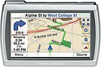
Harman Kardon GPS-300 Portable Navigation Device Announced


location based services


Posted by Admin on Thursday, May 31, 2007 - 02:09 pm:

gps-300

Harman Kardon® Launches Portable Navigation Device with 4" WQVGA Widescreen Touchscreen Display. The Guide + Play™ GPS-300 Combines Intuitive Portable Navigation With Full Featured Digital Music Player

Harman Kardon today announced the introduction of its Guide + Play GPS-300, a portable GPS navigation device with integrated MP3/WMA playback capability. The unit utilizes a sleek, 4" widescreen interface giving users access to a robust navigation system and digital music player with a simple touch of the screen. As one of only a small number of portable navigation devices capable of simultaneous music playback and navigation, the Guide + Play GPS-300 is the ideal device for portable entertainment and navigation needs.

Harman Kardon has leveraged its years of experience providing audio products for the home, computer and automotive markets to develop the Guide + Play GPS-300. The unit delivers an intuitive, consumer-friendly experience that provides a high-level of functionality and style. Clean design, a slim profile, and a crisp 4" WQVGA LCD touchscreen make the Guide + Play GPS-300 attractive and functional.

"Early response to our recently-introduced Harman Kardon GPS-500, the first portable navigation device to incorporate a consumer-friendly digital audio and video player, has been very enthusiastic. With the GPS-300, customers who want full-coverage GPS navigation without a full-fledged video player can now get the high-speed performance, superior ease-of-use, and four-inch widescreen graphic display of the GPS-500 at the breakthrough price of $299.99. We believe this is the best value in the market."

Harman Kardon's GPS-300 incorporates the following:
  1. Tightly integrated navigation and digital music player applications for simultaneous use. Both applications work together, ensuring that important navigation information is audible and displayed, even when digital-music playback is in use. Users may also set volume priority between the two functions.

  2. An easy-to-use touchscreen interface that lets users find key features and toggle between device menus with ease. The GPS-300 also includes a "Points of Interest" search that lets users find directions to nearby popular points of interest, such as restaurants, coffee shops or bookstores, with a simple touch of a button.

  3. A 4-inch widescreen WQVGA LCD display for high-quality viewing of maps. The widescreen aspect ratio allows users to see a larger map view when in GPS mode than do most GPS devices currently on the market. Additionally, a 480 x 272-pixel screen resolution ensures a clear and crisp viewing experience for enjoying the digital music player menus and detailed maps. Users can access up to 4GB of music loaded onto mini SD cards. The device supports MP3 and WMA music formats.

  4. A pocket-sized, virtually invisible portable mount that secures the slim (19.6mm in depth) GPS-300 for automotive use. The mount features a ball-and-socket joint that provides an almost unlimited number of viewing angles, allowing users to position the GPS-300's screen so that it can be seen from anywhere in the vehicle. The GPS-300 has up to five hours of battery life, 2GB of internal flash memory, up to 4GB optional external SD card flash memory, and a USB 2.0 full-speed interface, and includes a carrying case that's perfect for travel. The GPS-300 can be charged via its USB port that is compatible with both PC's and Macintosh® computers, or an in-car cigarette-lighter cable - all of which are included with the unit.
Pricing and Availability
The Harman Kardon Guide + Play GPS-300 is compatible with all automobiles. It features a pocket-sized portable mount. The GPS-300 will be available at quality retailers nationwide and at http://www.guideandplay.com beginning June 2007; it has a suggested retail price of $299.99.

About Harman Consumer Group
The Harman Consumer Group (HCG) is a leading designer, manufacturer and marketer of a wide range of high-fidelity loudspeakers, audio and video components, and multimedia systems for use in homes and automobiles, and with computers. The group's brands include JBL, Infinity, Harman Kardon, Mark Levinson, Revel, Audioaccess and Lexicon.

HCG is a division of Harman International Industries, Incorporated. Harman International (http://www.harman.com) is a leading manufacturer of high-quality, high-fidelity audio products and electronic systems for the automotive, consumer and professional markets. The company's stock is traded on the New York Stock Exchange under the symbol "HAR."

Is the GPS device now a PDA?

location based services

GPS is the new PDAA couple of weeks ago Gartner came out with a report that said PDA sales were up in Q1 2007, breaking the cycle of a downward trend in this category. However, digging deeper into the details of how they categorized PDAs was an interesting tidbit – Global Positioning System (GPS) device manufacturer Mio Technology was among the companies classified as PDA.

The portable navigation device is no longer just a device that sits in your car to give you driving directions, more features and abilities are being added that turn them more into portable computers (for lack of a better word), and maybe the PDA designation by Gartner is appropriate.

Witness, for example, today's announcement by Harman Kardon about its new Guide + Play GPS-300 (GPS-500, the older model, pictured). In addition to standard GPS functionality, the GPS-300 includes a digital music player with integrated MP3/WMA support and a 4-inch widescreen touchscreen display. The $300 device (available in June at this site) can play music and provide navigation simultaneously, and the device can store up to 2GB of music internally, and 4GB of music loaded on a SD card.

I wonder if this means that GPS devices will now have to be considered in the category of portable music player as well.