Friday, May 25, 2007

PluggedIn: Phones That Tell You Where To Drive, Meet, Eat

location based services

NEW YORK - Ever wish you could find directions to the nearest bookstore or coffee shop without asking a stranger? Maybe you're having trouble keeping tabs on your adventurous children?

Your cell phone could be the answer to such problems, as wireless companies have started to make commercial use of technologies originally developed to help emergency workers find callers in danger.

While relatively new, these mobile services have begun to build a following by making it easier for people to find their way around a strange city, meet up with friends, or get directions to a new restaurant or shop.

One new user, Milton Williams, who installs and maintains air conditioning units for Athens, Georgia-based D&B Heating and Air, recently threw out his old paper maps. He now uses a cell phone navigation system that verbally directs him to out-of-the-way customers once he's punched in their address.

"Everything is time here, going from one job to the other. It helps me tremendously," said Williams, who about a month ago signed up for a navigation service from Verizon Wireless, a venture of Verizon Communications Inc. and Vodafone Group Plc.

Roger Drissel, another worker who spends a lot of time on the road, uses Verizon's service for driving directions two to three times a day when he's on out-of-town jobs. He also uses it to find somewhere to eat by searching the phone for a restaurant type and following turn-by-turn directions.

"I don't have to worry about where I'm going, about where things are. All I need is the address on the phone and it tells me how to get there verbally," Drissel said.

'PEACE OF MIND'

Drissel, who manages information systems for Saber Corp., even stopped using a dedicated car-dashboard navigation system when he started using the Verizon cell phone service.

"That's another little box in my life. I don't even notice this is in my phone." he said.

But while he finds the wireless service easy, Drissel said it has not always helped him save time.

"It didn't always know that there may have been shorter routes than the one it gave me, but the route that it gave me has always been right," he said.

Nevertheless, judging from the growing number of customers, users appear willing to look past some of the shortcomings of cell phone navigation.

Networks In Motion, a privately held mobile navigation developer, says it has had a million customers, including one-time users who paid $3 a day and those who pay about $10 a month. Most of these customers come from Verizon Wireless.

Other providers include Sprint Nextel Corp, whose service includes local search functions from Ask.com and InfoSpace Inc that help phone users find shops or services based on where they are.

Helio, a venture of SK Telecom and EarthLink Inc., is among the companies that have taken the technology even further by letting groups of friends broadcast their location to each other to arrange spontaneous meetings.

Sprint, Verizon and Walt Disney Co. also offer services that let parents monitor the location of their kids, so long as they are equipped with cell phones. If a child wanders too far, an alert may be sent to the adult's phone.

Carroll Hannon, an Indianapolis-based mother of five, said she hopes to subscribe to the Disney service to help her look after her daughters, aged 11, 13 and 15.

"We liked having it, especially when we were on vacation," said Hannon, who recently tested phones from the three providers for a Money Magazine story.

"The children might be taking a walk on the beach and all I had to do was have them take their cell phone," she added. "It was just peace of mind."

But the friend and child locater services may not be for everybody, said IAG Research communications research vice president Roger Entner.

"It depends if you're the 'Every Breath You Take' or the 'If You Love Someone, Set Them Free' type person," said Entner, referring to two popular, Sting-penned rock songs to exemplify hands-on and hands-off personalities.

The customers interviewed for this story said they were not given incentives by the provider to talk about the services.


By: Sinead Carew

Where Are You?: GPS Text Message Device Acts Like an Emergency Beacon


location based services

posted Wednesday, 23 May 2007

freedomgps.jpgDid you know that when dialing 911 from your cellphone, the police can't pinpoint your location exactly? And that if you're dialing from a rural area, it becomes even worse—up to a five-mile radius? That's why this Freedom GPS text message unit is useful.

By programming in five numbers beforehand, you can activate the Freedom unit to send out your exact GPS location by SMS. This way your family members know exactly where you are when you get lost or stranded, which makes their "officer, I had no idea where to look for them, I swear!" excuse not hold up in court.

Product Page [Globalsources via Slashgear via Crunchgear]

GeoCommons: Bringing Data and Mashups to Professionals and Citizens Alike
By Adena Schutzberg , Directions Magazine
May 17, 2007

Sponsored Links:
The Microsoft Virtual Earth Platform is an integrated set of services that combines unique bird’s eye, aerial, and satellite imagery with best-of-breed mapping, location and search functionality. It enables businesses to deliver innovative solutions and breakthrough customer experiences. Learn more at www.microsoft.com/virtualearth.

Who is FortiusOne?
FortiusOne is not yet a household name in geospatial, but I suspect it will be soon. I first learned of one of the company’s founders in 2003, when he made the Washington Post. Sean Gorman, now CEO of FortiusOne, got into trouble for putting together "detailed maps of U.S. infrastructure along with the fiber-optic network that connects businesses and government. The data was all collected from public sources."

Back then, Gorman was a grad student at George Mason University. He started FortiusOne in 2005 with two professors to support work for the U.S. Department of Homeland Security. Markets Growth Fund and Walker Ventures provided the $500,000 in funding that got the company off the ground. FortiusOne secured another round of funding last week.

FortiusOne launched GeoIQ Web Services, a platform that "empowers you to go beyond pushpin data displays to add geographic intelligence to your maps," last year. (Location Intelligence ran a product overview.) More recently Gorman has been prepping for the next big thing: a repository for geodata available for mashups. Called GeoCommons, it's being announced today and will go live next week at the Where 2.0 Conference. I received a briefing from Gorman on a development version of the website last week.

GeoCommons
GeoCommons is quite a few things rolled into one. It's a website to:

  • upload, download and search for spatial data
  • easily create mashups by combining datasets
  • tell stories that are best told with real data on real maps
And, it has some features you won't find elsewhere:
  • the ability to create heat maps, a type of thematic map
  • data available under "Creative Commons with Attribution" licensing
  • proprietary geospatial data storage and search tools
Gorman explained that GeoCommons is about enabling regular people to use the wonders of maps and Web 2.0 to tell stories. What sort of stories? While the technology can be used to map your favorite fishing holes or bars, he positions it as a tool to make a point, to convince others of a point of view. For that reason, most of the example maps I saw were about timely issues: hurricanes, housing lenders, methadone labs. In fact, the testing team playing with GeoCommons was challenged to create interesting maps on topics in the news. FortiusOne hopes news providers will be key users of the technology. While focused on regular people, FortiusOne also offers a GeoCommons developer API for those who want to tap into the back-end tools.

GeoCommons in Action
The free site allows users to set up an account and profile, and upload their own datasets (after carefully reading the licensing information). Data must be public domain and can be uploaded in KML or shapefile format. (A future release will create these files from address information, that is, it'll do geocoding.) Datasets can be tagged and include a description, though no formal metadata tool is offered (at this time). Shapefile datasets are converted to KML, GeoCommons' "native" format. Alternatively, users can search for already loaded datasets based on geography and topic. Those datasets are fuel for mashups.

A GeoCommons profile lists maps created by the individual. (Click for larger image)


Form for uploading data into GeoCommons. (Click for larger image)


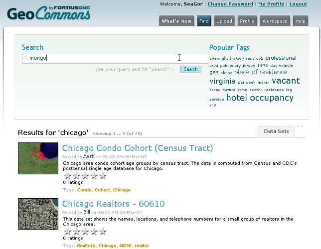
GeoCommons custom search tool. (This is not a Google search!) (Click for larger image)


Some of the results for search on "Chicago." (Click for larger image)


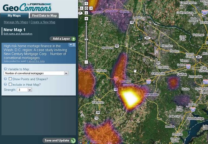
When a dataset is added to a new map it can be displayed as points and shapes and/or a heat map. A heat map is a thematic map of one or more variables based on FortiusOne's underlying mathematics. It's a "relative" map so no formal legend is provided. You can, however, look at the raw data to get a sense of the ranges and to see the values at specific locations.

Mashup built from data on high risk mortgages in the D.C. area. This shows just the heatmap. (Click for larger image)


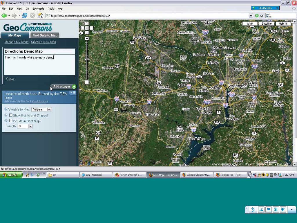
Saving a map involves giving it a name and description. At that point you can make the map public or private. Maps can be either, but datasets must be public, reinforcing the idea of a "commons." For now, registered users are provided with public URLs for their public maps. In the future, FortiusOne plans to add tools to embed maps in Web pages and blogs.

Saving a map. (Click for larger image)


The Business Side
FortiusOne has two ways to monetize GeoCommons. One involves a sort of "higher level" fee-based membership for individuals or organizations that want to tell the story around their cause in more detail. An environmental organization might have such a profile to tell its story of conservation or a political group might use it in a campaign to highlight inequities. A second monetization option revolves around those with data they can't (or choose not to) share. They pay a subscription to use the tools of GeoCommons along with their proprietary data. The model, says Gorman, is akin to Salesforce.com's hosted service for businesses.

My Take
This is a truly unique addition to the Web 2.0 world of mapping. I can't think of a real competitor. This is not Google My Maps because you can upload your own datasets. It's not Platial since there's no social, "here's where I went on my vacation" aspect to it. It's not a global spatial data infrastructure since there's no government involved!

So what is it? It's a place to share – not just maps, but data. It's a place to tell stories – stories about the environment, politics, natural disasters, real world topics. And, it's a mapping tool aimed at regular people. Gorman explained that the team took out lots of the high-end geospatial analytical tools in an earlier beta because they confused non-technical users. The plan is to slowly add those in as users become comfortable with the application.

There are challenges. Will users upload datasets? FortiusOne hopes so and has been seeding GeoCommons with public datasets on its own. Will the data follow the public domain creed? Again, FortiusOne hopes so and has staffers to review datasets and remove them should they be inappropriate (not unlike YouTube). Will enough paying customers step up to fund the free version? FortiusOne is optimistic, especially after the Department of Homeland Security acquired its technology specifically because its non-technical users could combine and use data quickly and easily.

I suspect geospatial professionals will be very pleased with GeoCommons as it "bridges the gap" between social and consumer mashup tools and the data they create day in, day out. I think at the outset these professionals will be the largest group of data uploaders. Non-technical users, who may be less familiar with shapefiles and KML, will likely first look to existing datasets in GeoCommons to build their maps. There's a nice synergy there. Further, if datasets continue to be regularly uploaded, GeoCommons may become the single search hub for public domain data worldwide.

In-car navigation processor gains 3D engine


location based services


Renesas is readying a high-end SoC (system-on-chip) for in-car navigation systems requiring accelerated 3D graphics. The SH7775 is based on a 600MHz SH-4a core, and integrates a GPS baseband from SiRF along with a 150MHz PowerVR MBX 3D graphics processor from Imagination Technologies, Renesas said.

Renesas describes the SH7775 as a "third-generation" car navigation SoC, after the earlier SH7774 and SH7770 parts. Compared to the SH7770, the SH7775 will offer 50 percent better floating point performance, and three times faster graphics, Renesas said.

As with the earlier SH777x parts, the new SH7775 is based on Renesas's SH-4A core, a 32-bit superscalar RISC core with integrated media processing instructions and a four-way, set-associative memory cache with 32KB each of instruction and data cache. Clocked at 600MHz in the SH7775, the core is said to deliver 1GIPS (giga instructions per second) and 4.2 GFLOPS (giga floating-point operations per second), making it the fastest chip ever based on the SuperH architecture.

The SH7775 uses the same 2D graphics engine as Renesas's earlier in-car nav chips, facilitating software forward compatibility, the company said. New in the SH7775 part, however, are 3D functions like triangle 3D drawing and texture mapping, useful for rendering buildings on maps, Renesas said. The SH7775's 3D capabilities are based on an PowerVR MBX 3D graphics engine from Imagination Technologies. Renesas will offer a "MAPGL" graphics API for the chip; and, Imagination also offers a PowerVR Insider SDK for content creators targeting its GPUs.

Other SH7775 on-chip peripherals and interfaces include:
  • GPS baseband processing module utilizing IP licensed from SiRF
  • ATAPI interface
  • USB v2.0 host/function interface
  • CAN in-vehicle LAN interface
  • Remote control interface, timers, etc..
  • Unified memory architecture allows memory sharing among peripherals
  • 32-bit dedicated bus for connections to high-speed DDR2-SDRAM (Double-Data-Rate-2 Synchronous DRAM)
  • 32-bit extension bus for connections to flash memory or SRAM
According to a Renesas spokesperson, "The SH7775 is capable of supporting major embedded operating systems such as QNX, Linux, Windows Automotive, ITRON and VxWorks." Since it is expected to support Windows Automotive, which is based on Windows CE 5.0, it presumably will support "standard" Windows CE.

Renesas said engineers can use its E10A-USB emulator for real-time on-chip debugging at the SH7775's full 600MHz operating frequency.

Availability

The SH7775 is expected to ship in July, priced at $70 in a 560-pin BGA package. An in-car navigation system reference platform said to include peripheral circuits for implementing a verification environment will also be offered.

Renesas also recently announced an SH-7785 SoC, also based on a 600MHz SH-4a core.


GPS interface for Nikon cameras from Red Hen Systems Map Digital Pictures

location based services


Written by Red Hen Systems
Tuesday, 22 May 2007Blue2can is an integrated solution for tagging digital still images with GPS data. Using a consumer, off-the-shelf BluetoothGPS unit and the industry leading Nikon D2X and D200* cameras, the Blue2can allows users to directly capture geospatially referenced images in the easiest, most reliable collection method today.

Direct Capture The Blue2can provides camera area network solutions for Bluetooth GPS models to the ten pin portal of the camera. Through the Bluetooth camera area network, the Nikon D2X and D200 captures the data being streamed into its GPS input port, directly populating the EXIF metadata of the JPEG image file. With direct capture, users of the Blue2can will save time and reduce errors in image mapping. Information captured in the EXIF metadata of the JPEG image file can be read by Red Hen Systems MediaMapper, IsWhere and PixPoint for ArcGIS to create map features linked directly to the photo file or used in any mapping application that supports EXIF GPS metadata. Tagging images with GPS metadata as soon as they are taken eliminates the post-processing steps required with most other methodologies. The union of time, date, and location data with imagery is a powerful model enabling informed decision-making. Blue2can Features The Bluetooth GPS unit may be mounted on top of the camera, carried in a pocket, or put on the dash of your car. Physical integration eliminates all cables Instantly inspect and view data on the camera LCD Very simple to use, just plug it in and go. Industry standard GPS -data tagging offers compatibility with most GIS and mapping systems Includes IsWhere picture mapping software that operates in conjunction with Google Earth Release date 5/25/2007Price:$279.95 without Bluetooth GPSRed Hen Systems, Inc.2850 McClelland Drive Suite 3900Fort Collins, Colorado 80525 (800) 237-4182 (970) 493-3952www.redhensystems.com

Number of comments (0) - Add your

Thursday, May 24, 2007

Apple to incorporate GPS into next iPhone

location based services


Apple is hard at work making the next version of the iPhone worth every penny of its subsidized $499 price tag. The next iPhone probably due out at Macworld or early spring of '08 will incorporate a GPS receiver chip closely matching the SiRFstarIII from SiRF Technology. Even though the StarIII’s power consumption is a bit higher than Apple would like it is considered the best chip for a mobile device of this kind, having the capability to receive signals from 20 different satellites simultaneously and a super fast First Fix Time.
Because of the high expectations placed upon the iPhone, Apple is certain to use a chipset using Assisted GPS technology, which cuts down the time needed to determine a location using GPS. (A-GPS) is necessary in urban areas with tall buildings or locations with heavy tree cover.
The first phone/GPS devise to fully utilize this technology is CNS-4320 from DiXCOM. The CNS-4320 hybrid device uses GSM radio with GPRS data for text and multimedia messaging. DiXCOM has also equipped the CNS with the Traffic Message Channel (TMC) for real time traffic information, a technology Apple is thought to be developing.
May 21, 2007
Mobile Market at Risk as New Applications Fail to Meet Consumer Needs

location based services

NewswireToday - /newswire/ - London, United Kingdom, 05/24/2007 - Consumers increasingly suspicious of overly complex and pricey mobile content applications, market assessment by Alpheus shows.


Alpheus Solutions Ltd today released a mobile content market assessment paper pinpointing risks the mobile industry faces from failing to align new services and applications adequately with consumer demands.Focusing on the promise of new services such as mobile advertising, social networking, location-based services (LBS) and mobile TV, Alpheus’ report looked at how to increase the likelihood of mass adoption of new content services. The major finding of the research was that undermining all of these new markets is a major risk of services not aligning with consumer demand. The research showed that consumers are increasingly suspicious of complex applications that don't meet their needs and potentially add to their mobile phone costs.“Our assessment clearly shows the market is running the risk of losing billions from poorly planned services,” said Nick Sex, chief operating officer of Alpheus. “People are suspicious of paying too much for disappointing services. Yet operators are now in a position to change all that – many services are now closer to being launched, and the key is that mobile operators need to get that launch right, the first time.”Alpheus’ findings on the specific markets included the following:• Social networking: There are two issues holding the market back - cost of data charges (e.g., consumers are not convinced they should pay to upload a video to YouTube via mobile when it is effectively free on a PC) and interoperability - people want to interact with their network of contacts irrespective of what device or network they use. On the plus side, with more powerful cameras, phones are now perfect for 'citizen journalism' – giving the immediacy that a PC doesn't have.• Fixed/mobile convergence: Market data suggests that it is not taking off as fast as people claim – users want proven additional features, simplicity and cost savings rather than simply agreeing with the benefits of convergence outright.• Mobile advertising: The main success factor is that a mobile ad will ‘jump out at you’ - on TV advertisers generally have 30 seconds to get a message across, less on the web and just a few seconds on a mobile. But it is the ideas that are more exciting than technology. Creativity is the differentiator and excellence in technical implementation nothing more than a given. Timing is also an issue – at the moment there is no mechanism for controlling the timing of when an ad arrives – leading it open to risk of being distracting and hence harmful to the brand. Mobile coupons are an area that is growing in interest, as they can drive people to visit shops rather than buy over the Internet. Finally, data charges are an issue – people don't want to pay to receive ads.• Location based services (LBS) and advertising: The mobile platform allows functions that can’t traditionally be done on the Web or TV, like using LBS. By combining contextual search, LBS and advertising operators can not only send ads to subscribers in response to requests, but also by analysing texts. So, if you’d just texted a friend while in the West End suggesting meeting up for a meal, it could come back with an ad for a restaurant located within 10 metres of your location, or a list of all restaurants in that area. With privacy implications, the market needs to agree where tailoring and personalisation stop and Big Brother begins.• Mobile TV: Alpheus’ assessment suggests the market may be held back by two factors, (i) screen size/resolution and (ii) how mobile TV fits into the existing TV distribution landscape, for example, users won’t pay twice for TV they already get at home. The key to cracking this issue may be (a) bite size TV (E.g. news) that people can access while travelling (supported by research by Orange reporting that the average use of Mobile TV is two and half minutes per day and (b) add-on TV/DIY TV allowing people to upload clips to the likes of YouTube, or download extra features or special features for their favourite TV shows. Another potential revenue stream exists in moving content off mobile phones onto TVs or PCs where it is easier to view.Please note that Alpheus’ complete mobile content market assessment can be requested by sending an email.


This article was published at no charge to their issuers. Only PREMIUM Articles are 3rd party Ad-Free!
amAze Enables DigitalGlobe Satellite Imagery on Mobile Phones
LocatioNet Leverages DigitalGlobe's High Resolution Satellite and Aerial Imagery for amAze Mobile Navigation Application


location based services

LONDON, and LONGMONT, Colo., May 21 /PRNewswire/ -- LocatioNet Systems Ltd., a leading provider of mobile mapping and location applications, and DigitalGlobe, the provider of the world's highest-resolution imagery and geospatial information products, today announced a partnership that adds DigitalGlobe's global satellite imagery to the amAze mobile service.
This collaboration means that for the first time, worldwide voice-guided GPS navigation is enabled over high resolution satellite imagery and aerial photos with regular mass-market phones.
DigitalGlobe has joined the amAze collaborative initiative, led by LocatioNet. amAze is a revolutionary navigation, mapping and local search service supported by several industry leading vendors. It offers services free to mobile users and generates revenue from the emerging mobile advertisement model. The application provides any regular, Java-enabled mobile phone with navigation and local search information over maps and DigitalGlobe satellite imagery in Europe and North America. A full voice-guided navigation feature is available for users with any Bluetooth GPS device.
"Satellite imagery has proved a great success over the Internet," said Ofer Tziperman, president of LocatioNet. "This is the first time such a rich mapping layer is being used for off-board GPS navigation on mass-market phones. We are very excited about this collaboration with DigitalGlobe, it is yet another innovative solution offered under the amAze initiative. Since amAze was launched a few weeks ago we have seen keen adoption by users from all over the globe using it for free. As part of our on-going service, additional features are being planned to further enrich amAze."
"We are very pleased to take part in this first of its kind service," said Jill Smith, CEO of DigitalGlobe. "Our satellite imagery and aerial photos provide a useful dimension to GPS navigation. The fact that amAze is capable to use our imagery archive for navigation on regular phones opens the opportunity for people around the world to experience the benefits of content-rich mapping layer. We look forward to supplying LocatioNet with the highest-resolution satellite imagery available."
LocatioNet's GIS technology enables fast enough streaming of aerial photos from the huge backend databases to the thin client mobile phone over the wireless networks, to allow real-time navigation over the aerial photo.
amAze already supports over 100 Java-enabled mobile handsets with more handsets supported every week. Windows mobile and BlackBerry versions will be released soon.
Users can log into the amAze web site: http://www.amazegps.com/ to register and obtain their free copy of this first of its kind useful mobile software.
About DigitalGlobe
Longmont, Colo. -- based DigitalGlobe (http://www.digitalglobe.com/) is the clear leader in the global commercial Earth imagery and geospatial information market. The company's technical superiority and innovation, unparalleled commitment to customer service, extensive business partner network and open systems philosophy make DigitalGlobe the preferred supplier of imagery products to government and commercial markets. DigitalGlobe is the only geospatial content provider to take an end-to-end approach to geospatial imagery, from acquiring proprietary high-resolution images through a leading-edge satellite and aerial network, to integrating and distributing that data through GlobeXplorer, a proprietary web-based search and retrieval system that makes it easy to find, purchase and download global imagery. DigitalGlobe's QuickBird satellite is the world's highest resolution commercial imaging system. The company's next-generation WorldView 1 satellite is scheduled to launch in mid-2007, and its WorldView 2 satellite is anticipated to launch in late 2008. The company's updated and growing ImageLibrary contains over two hundred million square kilometers of QuickBird imagery and an extensive global library of aerial imagery suited to countless mapping and planning needs.
About LocatioNet
With a track record of over 16 years in the field of location-based services, LocatioNet (http://www.locationet.com/) is best positioned to re-define the navigation and local search market. Based on a field proven LBS middleware, best of its kind GIS engine and advanced client-server technology, LocatioNet is serving mobile carriers, yellow pages vendors and other content providers. The solution is hosted from Europe, USA and Asia. Website: http://www.digitalglobe
NAVTEQ's Traffic.com Launches JamCast(R) Video Online


Pa., May 22 -- Traffic.com, a NAVTEQ company and a leading provider of personalized traffic information for drivers coast-to-coast, has launched JamCast(R) real-time traffic video at JamCast solutions are continuous, automatic, digitally managed services for the delivery of real-time traffic news across Web, television, radio and wireless platforms. JamCast features patented Jam Factor(R) roadway traffic measurements that allow commuters to easily understand the relative congestion level with a number on a scale from 1 to 10."JamCast furthers our efforts to deliver the highest-quality, accurate and visually compelling traffic information to commuters on-air, on-line, and on-the-go," said John MacLeod, Executive Vice President of NAVTEQ. "By delivering free real-time traffic video content across all digital media direct to commuters, we are helping drivers save time and money with valuable information they can access in real time and in whatever form they want and need."About Traffic.comTraffic.com is a leading provider of personalized traffic information for drivers coast-to-coast. Through Traffic.com's advanced data collection infrastructure, Traffic.com provides comprehensive coverage to 72 Designated Market Areas (DMAs) and 107 Core Based Statistical Areas (CBSAs) encompassing the most traffic congested U.S. cities. Traffic.com(R) solutions include predictive traffic trends, vehicle speeds, congestion levels, travel times, and delay times. Customers include broadcast media, interactive, portable navigation, data services businesses and government agencies, and solutions are delivered via radio, television, Web, wireless device, and in-vehicle navigation systems. Traffic.com's unique multi-platform distribution network creates unique, powerful branding opportunities for advertisers, enabling them to expand their reach and target consumers with useful, relevant content multiple times per day.The Traffic.com logo, Traffic.com, Jam Factor and JamCast are registered trademarks of Traffic.com, Inc. All other product or service names or marks are the property of their respective owners. (C) 2007 Traffic.com, Inc.Features of JamCast are protected by U.S. Patent No. 7,116,326. Jam Factor is protected by U.S. Patent No. 7,203,595About NAVTEQNAVTEQ is a leading provider of comprehensive digital map information for automotive navigation systems, mobile navigation devices, Internet-based mapping applications, and government and business solutions. NAVTEQ creates the digital maps and map content that power navigation and location-based services solutions around the world. The Chicago-based company was founded in 1985 and has approximately 2,800 employees located in 167 offices in 28 countries.

Wednesday, May 23, 2007

Killer Apps Wanted for 3G


location based services

Filed in archive Mobile Content by tom on May 21, 2007


Reuters have a story today (via Moconews) about the desire of 3G carriers for the 'killer app' that will eventually make 3G services repay the investment the carriers have made in infrastructure.
"I've got a 3G phone but I don't use '3G features'," said Kang Hatan, a research fellow in a lab in Seoul. "Video calls are too expensive and it's hard to find time to watch mobile TV."Analysts say many operators have neglected the development of content and services that their customers want in their headlong pursuit of new technology. Meanwhile users are still mostly just using their phones to make voice calls and send text messages.The typical thinking being espoused is that of music and video downloads, and localised search services based on the GPS devices built into some high-end handsets, although interestingly no mention is made of the current failure of location based services, which is caused entirely on the price that operators charge for access to such services. The report also discusses, albeit briefly, 4th generation services which will allow even higher speeds. One interesting thing I found is that nowhere is it discussed that perhaps a primary factor in the slow uptake of some services (and again I'm thinking of location based services among others) is the raw cost of these services, a cost which often has no bearing on the cost to provide. James at Moconews also floats the idea that the killer app already exists - SMS:
I'm with the camp that says there is no killer app for 3G, it will take a variety of services and applications to attract different people. SMS and e-mail are listed as having high take-up (unsurprising since they're communication tools) and LBS is touted as providing the final push that will spur uptake.He goes on to note:
Tom Bradley, EVP at HP, suggested that rather than spend a lot of money on marketing 3G carriers would to better to migrate "bread-and-butter office applications" onto the service, an "if you build it they will come"' approach.I tend to agree with Tom Bradley and James, especially given the history of SMS, which is a very good example of the 'build it' principle at work.
Permalink: Killer Apps Wanted for 3G Tags: mobile 3g 2007 killer apps killer+apps apps+wanted mobile+technology
Trackback: http://www.creative-weblogging.com/cgi-bin/mt-tb.pl/71031
Protocol for Location Based Services developed by the University of Illinois


Science Daily reported on May 21, 2007, that researchers* at the University of Illinois have developed a protocol for Geographic Information Systems (GIS) that was adopted by the International Standards Organization (ISO) earlier this year. This protocol forms what one researcher says is the “backbone” for Location Based Services (LBS), or the ability to track physical locations electronically. LBS has already been introduced on cell phones in Korea and Japan and is now becoming available in the United States.
Beyond the obvious ability to track a person through their cell phone, LBS promises to be able to function as a “hotel concierge,” providing information about available products and services or even locations where traffic is congested. The U of I researchers applauded ISO’s adoption of the standard, saying that the goal was to “provide efficient service at the least cost” by trying to avoid a standards war like the Beta/VHS war back in the 1980s. Read the Science Daily article here.
The Good:
LBS promises to provide services that many people will want to have. Parents would like to be able to track their children, particularly given the dangers those children face in an increasingly dangerous world. First responders will be able to use the service to track down missing people or people in need of emergency services, and corporations would like to be able to advertise their locations and products in ways that make it easy for consumers to find them.
The Bad:
Privacy advocates will point to the “Big Brother” type applications for law enforcement and government.
The Ugly:
It will be far more difficult to play hooky from work to attend a sporting event if the boss can track you down.
More Information:
KPN tests location-based services (Telecom Paper)
BBC Bets Its Future On Location-Based Services (MocoNews)
A British company wants to use lampposts for LBS (News.com)
There are an incredible number of applications possible for LBS, from targeted advertisements reminiscent of “Minority Report” to improved EMS and Search and Rescue operations. What are the implications for the use of LBS in the United States? Are there privacy safeguards that should be put into place before LBS takes off here? Is LBS a panacea for paranoid parents or a living nightmare for privacy advocates? Join the discussion.
*T. John Kim, professor of urban and regional planning and postdoctoral fellow Sung-Gheel Jang were the researchers who created the standard adopted by the ISO.
Small rugged GPS handset gains wireless carrier

location based services

Intermec's CN3 mobile computer, claimed to be the "smallest rugged mobile computer in the world," has been approved for voice and data transmission on AT&T's U.S. wireless data network. The CN3, which runs Windows Mobile 5.0, is also available bundled with transportation and delivery application software, according to the Intermec.The CN3's built-in GPS capability can be used with AT&T's TeleNav Navigator and Track applications "to provide turn by turn directions and mobile resource management to track assets in the field," according to an AT&T spokesperson.The bundled transportation software from Intermec partner Cheetah Software Systems provides optimized route planning, intelligent dispatch, real-time tracking of pick up and delivery information, signature capture, and GPS location and navigational capabilities, along with driver voice and data communications, Intermec said.The ruggedized CN3, introduced last September, runs Windows Mobile 5.0 on a 520 MHz PXA270 processor and is equipped with 128 MB each of RAM and flash memory. It integrates WiFi, Bluetooth, GPS, and either GSM/EDGE or CDMA/EV-DO wireless functions, and is offered with either a 1.3 Mpixel camera or a 2D imager for bar code scanning. Further details and specifications on the device appear in our prior coverage of the device.
uLocate Receives $11 Million for Their Mobile Location Services

location based services


May 20, 2007

uLocate Communications Inc. receives $11 million as a business to business provider of mobile location services. Investors included Venrock Associates, GrandBanks Capital, and Kodiak Venture Partners.

What does uLocate do?

uLocate provides mobile location services to carriers and other mobile providers.

VCU says:

While uLocate provides mobile location services, it appears that just recently they announced "Where". "Where" is a mobile GPS widget platform. Consumers can find widgets for their mobile phones but more importantly developers have access to GPS functionality.

We will continue to follow similar fundings. Take a look at uLocate.com.

Monday, May 21, 2007

Galileo rubidium clocks – a year of in-orbit experience

location based services

Europe’s first satellite-borne rubidium clocks have been in orbit for over a year. There is good news for the building of the Galileo system: the results obtained from GIOVE-A’s first year of operations show performance that is largely in line with the specifications.
GIOVE-A, the first Galileo in-orbit validation element, was launched on 28 December 2005. One of its two rubidium clocks was switched on for the first time on 10 January 2006 and Galileo signals were transmitted two days later. The timekeeping of the clocks on the Galileo spacecraft will play an important role in determining the overall accuracy of the system, so evaluation of their performance is a crucial part of the Galileo in-orbit verification process. Indirect measurement The orbit of GIOVE-A is precisely measured by a network of 10 ground-based laser ranging stations, to provide orbital data independent of the navigation data. The navigation signals broadcast from GIOVE-A, and from the GPS spacecraft constellation, are received by the world-wide network of 13 Galileo experimental sensor stations belonging to the GIOVE Mission Segment. The technique used to characterise clock performance is known as Orbit Determination and Time Synchronisation (ODTS). ODTS is a statistical method which takes the Galileo and GPS data, together with the laser ranging data, and calculates spacecraft orbits, clock times, the effects of the Earth’s atmosphere on the radio signals and the delays in the receiving systems. The precision of the calculations is so great that even the tiny orbit disturbances caused by the pressure of sunlight shining on the satellites is taken into account. The ground systems cannot measure the ‘pure’ clock performance on-board GIOVE-A. The ‘apparent’ clock performance observed on the ground is seen through the satellite signal generation chain, the radio transmission path through space, the receiver network and the algorithm used to perform the performance estimation.


Performance to date Comparisons between the on-board clocks and identical units undergoing on-ground life testing show that no unexpected ageing or performance degradation is occurring due to the space environment. Extrapolation of performance measurements for limited-life components such as the rubidium lamps shows that they will easily exceed the required 12-year operational lifetime. The measured performance of the clocks meets the specification over short and medium timescales. A few ‘jumps’ in clock frequency have been observed, which impact the long term accuracy. Such frequency changes are a well known phenomenon in rubidium clock technology but their cause is not yet well understood. Their effect on GPS performance has already been analysed and corrective measures proposed. The Galileo team are ground testing a number of improvements to the clock design which are intended to minimise both the occurrence and size of the jumps. Galileo is a joint initiative between ESA and the European Commission. When fully deployed in the early years of the next decade, it will be the first civilian positioning system to offer global coverage. Source: ESA

Sunday, May 20, 2007

Souping Up Your Cell Phone

location based services


With the right software, mobile devices can perform powerful tricks. Laptops continue to get lighter and more powerful, but would you carry one if you could get what you want from a cell phone? New applications offering everything from news to fax service to entertainment have made it possible to fit many more functions into this pocket-size package. Just be aware that if you want them, you'll probably need to purchase a wireless data plan through your cell phone carrier. Voice and data packages typically start at around $80 a month.


VZ Navigator, included on most Verizon Wireless (VZ ) phones, is one application I have been relying on. For $9.99 a month, or $2.99 a day, Navigator uses a Motorola (MOT ) Razr, LG Chocolate, or other phone's GPS capability to pinpoint your location on easy-to-read color maps. Better yet, if you type in your destination (not while you're driving, of course) it will provide turn-by-turn directions via voice as you go. En route, the Navigator can direct you to gas stations, restaurants, and ATMs, and lets you call for reservations or hours with the click of a button.Another of my favorites is Google SMS, which is currently in a beta version. It lets me check a flight status by simply texting my airline's name and flight number to 466453. Within seconds I receive a text message with departure and arrival times and gate number. Google SMS can also fetch driving directions and business listings and answer random questions such as "How much is $1 in euros?" Be forewarned: You have to master special Google syntax, such as "sushi 97229," to find the nearest Japanese restaurant in a particular Zip Code. You can get guidance online.At meetings on the run, I've found mobile-software scanR can forestall the need for a trip to FedEx Kinko's (FDX ). Once I snap a photo of a business card or a document with my camera-phone, scanR lets me e-mail or fax the picture to a colleague. (Phones typically let you send photos only to another mobile phone.) The application also forwards the shot to my personal scanR Web page so I can upload the scanned business cards into my Outlook address book with just a click. No typing is involved. The service is free for up to five scans a month and costs $3 a month for higher usage.SPLIT THE CHECK, WIRELESSLYTo read headlines and news summaries, I use a free early version of Yahoo! (YHOO ) Go for Mobile 2.0. The software, which works on more than 100 phone models, also lets me check local weather and respond to e-mail. The application's convenient menu, allowing you to scroll through pictures, feels more intuitive than the typical searching through lists.With another service, Obopay, I can split a lunch bill without whipping out cash or my checkbook. It lets me use my cell phone to make person-to-person money transfers instantly via text messages. The service, which charges a 10 cents fee per transaction for sending funds, also comes with a prepaid cash card, which is accepted anywhere that takes MasterCard. One grudge: The person I am splitting the bill with has to register with Obopay to access the money, so cash can still come in handy.Unwinding in between meetings, I like to listen to mobile podcasts. While nearly all wireless carriers offer a way to get them, I have recently fallen in love with the free VoiceIndigo application that comes preloaded onto Samsung's UpStage music phone from Sprint Nextel (S ). Besides good sound quality and stellar content, such as programs from National Public Radio and The Onion, the software offers interactive features. I can send a podcast to a friend by typing in a phone number. Or I can text or call podcast creators directly, although many publishers have failed to enable the function.Mobile music is finally taking flight. One service, Mercora, lets me listen to hundreds of radio channels with a smartphone and even access my friends' music libraries, stored on home PCs that have Mercora's free sharing software installed. Sound quality can be iffy or good, depending on connection, but the service costs only $14.99 a quarter or $49.99 a year. If you have an extensive music collection yourself, you can download a Mercora desktop application onto your PC for free and access your songs remotely with Windows Mobile (MSFT ) 5.0 and PocketPC smartphones, such as Motorola's Q.Similarly, I can tap into my home TV channels or shows recorded on my digital video recorder (DVR) using software called SlingPlayer Mobile from Sling Media. To make it work, I spent a few hours hooking up several hundred dollars' worth of hardware to my laptop and cable box. You also have to pay $29.99 for the mobile application for a Pocket PC or Windows Mobile device. But all that effort let me watch my home television and direct my DVR to record shows remotely. Image quality can be fuzzy, and changing channels takes a while, but it works for watching shows on the go.Mobile-TV service from Verizon Wireless can offer a better picture. Called V Cast Mobile TV, it lets me watch eight basic broadcast channels, including Fox Mobile, MTV, and CBS Mobile, for as little as $15 a month via a special mobile-TV phone. (I used an LGVX9400 and loved its swivel screen, which allows you to watch video in landscape or portrait views.) A channel guide told me exactly when Prison Break would start. One bummer if you are an avid TV watcher: You'll be seeing most shows a day after they have been broadcast. Also, mobile coverage can be spotty. In certain areas, I couldn't see a thing. In other locations, video quality was stellar. But hey, if this service can cut down on my boredom while sitting in traffic or at the airport, it's well worth it.
Mobile Traffic Apps At Tipping Point

location based services

By James Quintana Pearce - Sun 20 May 2007 04:15 PM PST
The use of mobile location based services for things like navigation and traffic reporting is at the tipping point, according to Sean Ryan, research analyst at IDC. This is due to both an increase in the number of carriers offering services and the lowering costs of GPS chipsets, which will come down to a price that will see them as a common feature of phones, reports Wireless Week. As well as navigation (routes to places) traffic monitoring is big—which should be attractive to the carriers, because while getting directions to an unknown location is relatively uncommon, the route to work is something that a lot of people do almost every day, by definition.
Measurements: An interesting aspect of the article is the different ways companies have come up with to measure traffic: Some turn to companies like Intrix, which aggregates traffic information from government departments and GPS data from working vehicles to figure out traffic conditions; AirSage uses location data from Sprint’s 50 million users to get a picture of traffic; and 3rd Dimension simply offers an application that connects to traffic cameras. The eventual aim is to integrate traffic data and LBS into other applications and make the stand-alone applications more useful. For example, an application could report on an accident up ahead and suggest an alternate route. Although I did like the use of traffic cameras to watch the Macy’s Day Parade in Dallas.
SDK enables customized Windows CE navigation apps

location based services

Jan. 23, 2007Magellan has released a software development kit (SDK) aimed at helping device makers create customized navigation applications. The NavCreator SDK supports capabilities such as routing, guidance, and traffic data, and can be used in conjunction with PDAs, mobile phones, personal navigation devices, and in-vehicle navigation systems running Windows CE 5.0, according to the company.
Features of NavCreator, according to Magellan, include:
Turn-by-turn navigation modules
APIs for defining the application GUI
Standard or custom map databases for North America or Europe
3D/2.5D map draw
Multi-language support
Components:
routing
guidance
traffic
saved settings
active trip Magellan is well known as a leader navigation technology, and was a key partner in the development and deployment of the popular Hertz NeverLost system.According to Hubert Canuet, general manager of Magellan's OEM business unit, NavCreator will enable device OEMs (original equipment manufacturers) and ODMs (original design manufacturers) to "differentiate their navigation solutions by adding their graphical user interface to Magellan's navigation software technology."The NavCreator SDK appears to be immediately available. Pricing was not disclosed.
NET CF wrapper helps create GPS-enabled apps

location based services


Apr. 12, 2007In The Hand Ltd. has released software intended to help developers create GPS-enabled applications for handheld devices. "TomTom In The Hand" provides a .NET Compact Framework "wrapper" for use with GPS specialist TomTom International's "Navigator SDK" (software development kit) for developers of integrated handheld navigation solutions.TomTom says its Navigator SDK lets developers integrate its Navigator GPS software for Pocket PC and Windows Mobile 5 devices with "almost any existing mobile business application." Capabilities of the TomTom Navigator SDK (along with associated Navigator software), as listed by TomTom, include:
Connect TomTom Navigator to your mobile business applications using the TomTom API
Add your key locations in self-defined categories to TomTom maps using custom icons
Start your own business applications directly from the TomTom NAVIGATOR main menu
Access to a full GPS data stream for external applications which use unfiltered GPS data
Adjust the configuration and settings and tailor TomTom NAVIGATOR to your specific needs
Reference extensive support documentation and sample source code for easy implementationTomTom's Navigator SDK supports a wide range of GPS-enabled devices that run Windows Mobile and Windows CE platforms, from a wide range of manufactures such as Acer, Asus, Dell, Eten, Fujitsu Siemens, HP, HTC, Imate, Mitac, O2, Orange, Palm, Qtek, SFR, T-Mobile, and others..NET CF wrapperIn The Hand's .NET Compact Framework (CF) wrapper for TomTom's Navigator SDK is said to make "all the functionality found in the C++ API exposed by TomTom easily accessible from ... managed VB or C# applications." The In The Hand library is compatible with both .NET CF v1.0 and v2.0 and works with Visual Studio 2005, the company says. Documentation is integrated into the Visual Studio help collection, and a sample application is included that demonstrates using the API to log positions, In The Hand adds.TomTom In The Hand is available for about $130 from Handango on a per-developer license basis, which permits unlimited redistribution of the runtime dll with developed applications. Developers must also purchase the TomTom Navigator SDK and Navigator software for Pocket PC or Windows Mobile separately, In The Hand notes. TomTom In The Hand is one of several In The Hand products aim to ease the development of mobile applications utilizing the .NET Compact Framework.
Partnership adds location context to mobile apps
May 17, 2007

location based services


GPS chip vendor SiRF Technology and communication software specialist Openwave Systems are teaming up to add location awareness to Web 2.0 mobile applications. The collaboration aims to enable developers to easily add location context to mobile widgets, rich data services, and online idle-screen user interfaces on mobile devices, the companies say.

Specifically, SiRF will integrate the location capabilities of its SiRFstudio with Openwave's MIDAS, described as a Mobile AJAX-based application development platform. The location-enabled MIDAS platform offers content publishers and developers easy access to a variety of location functionality -- from location determination to mapping and routing -- that provide end users with a "rich location experience," according to Openwave. The platform also includes tools to create idle-screen widgets and a framework for widget discovery, delivery, and lifecycle management.

SiRFstudio provides handset manufacturers and carriers with location "platforming" and integration capabilities that deliver an "out-of-the-box locative experience" for mobile devices, SiRF says. It also provides a rapid LBS (location-based services) application development platform for embedding sophisticated location capabilities into new and existing applications or services, according to SiRF.

According to Nara Rajagopalan, VP of products at Openwave, "A key part of creating mobile services with a highly targeted and personalized experience is knowing where subscribers are, and the integration of the SiRFstudio APIs with MIDAS is designed to bring high-accuracy location technology within the reach of content publishers and developers. When combined with other existing content feeds and services in addition to other applications, location adds the geographic dimension and filtering needed to create compelling and highly relevant mobile data services that can drive Web content consumption on mobile devices."

MIDAS creates applications that run on Windows Mobile, Symbian, BREW, QTopia, Linux, and "any feature phone platform," Openwave said.

SiRF Technology and Openwave plan to jointly market the combined software to wireless operators and mobile handset and device OEMs (original equipment manufacturers), the companies said.
Nortel Demonstrates the Power of 4G

location based services

Do you receive our FREE 3G Newsletter ? If not click here
16th May , 2007
ASIA Singapore : Nortel is showcasing its WiMAX solutions for delivering bandwidth-hungry mobile video applications during WiMAX Asia 2007. The region's leading wireless broadband event focuses on WiMAX business opportunities, challenges, technology solutions and applications.
A pioneer in OFDM and MIMO technologies, Nortel is a leader in the development of 4G solutions designed to meet the challenges of an increasingly hyperconnected world, where anything that can be connected to the network will be. As demand for mobile access to high-bandwidth services like video increases, a mobile network's ability to cope with a multitude of connected devices and services is becoming critical. To help meet this demand, service providers need the added speed, scalability, efficiency and affordability of a 4G WiMAX network.
Nortel's demonstrations at WiMAX Asia 2007 will focus on how WiMAX deployments can deliver superior results for VoIP, streaming video applications, mobile IPTV, municipal wireless solutions, video surveillance and a host of enterprise unified communications applications. Nortel's WiMAX solutions are built for speed and capacity and leverage multiple devices - all at as little as one-tenth the cost-per-bit of 3G technologies.
"Today, no single vendor can deliver a complete WiMAX solution alone," said Peter MacKinnon, general manager, Nortel WiMAX and Wireless Mesh, and chairman, LG-Nortel. "Nortel's approach in creating a WiMAX ecosystem of best-in-breed partnerships to meet the market's needs will reinforce our position as an industry leader in demonstrating the enhanced real-time communications benefits of a truly mobile communications experience."
Nortel recently ran an extensive mobile WiMAX trial in Australia with Austar, a member of the Liberty Global media group. The trials included successful WiMAX VoIP calls demonstrated over an end-to-end Quality of Service class.
Nortel's WiMAX solutions are powering Taiwan's Mobile Healthcare Services ("M-Care") through a recently announced agreement with Chunghwa Telecom. A live demonstration on "M-Care" was held with Chunghwa Telecom during the Taipei Summit - Asia Pacific WiMAX Conference & Exhibition, held in Taiwan May 14 and 15. At the Taipei Summit, Nortel also signed a memorandum of understanding (MoU) with the Taiwan Ministry of Economic Affairs to jointly develop a full end-to-end WiMAX ecosystem, and announced the establishment of a Center of Excellence-WiMAX 4G Ecosystem in Taipei. Nortel is trialing and deploying its WiMAX solutions with a number of carriers around the world, notably in Taiwan, Australia, USA, Germany, Canada, Greece, Russia and Mexico.
Nortel is a Gold Sponsor of WiMAX Asia 2007, which will take place in the Shangri-la Hotel from May 15 to 17. Nortel experts will be involved in the following conferences and pre-conference workshops:
May 14, 2007 - 9:30am to 5pm Pre-conference workshop: Understanding WiMAX & Wi-Fi Mesh Networking and Its Implications with Nortel presenters - Sunny Ang, WiMAX RF Engineering; Meng-Yew Ng, WiMAX Core Engineering, Asia; Anup Changaroth, Metro Ethernet Networks Marketing, Asia.
May 15, 2007 - 9:15am presentation: WiMAX Devices & Handsets with updates on WiMAX Certification Programme, presenter - Stone Tseng, Director WiMAX Ecosystem, Nortel, Taiwan; 2:30pm presentation: MIMO-OFDM - Delivering on the Promise of WiMAX, presenter - Nick Bromhead, WiMAX Marketing, Asia, Nortel; 3:30pm panel: Strategies to maximize Mobile WiMAX performance, capacity and coverage, moderator - Darryl Worthington, Director, Asia WiMAX Networks, Nortel.

Image Map Satellite Yahoo


location based services

Free Satellite Map Tool
Using Earth Software you can view a Satellite Map of Anywhere, Free!
satellite-maps.googlepages.com
Google Maps
Street maps & satellite images of your local area.
maps.google.com.au
Satellite Map
Search For Satellite Map Search Today!
www.live.com.au
Satellite
Complete and easy to use: TomTom all-in-one navigation!
www.TomTom.com
Free - Satellite Images
Get free live Satellite Images of your home, city, or street.
PhotosSatellite.info

Free Satellite Map Tool
Using Earth Software you can view Satellite Maps of Anywhere, Free!
Satellite-Map.Googlepages.com
Google Maps
Easy-to-use online maps with local listings and driving directions.
maps.google.com.au
Satellite Map
Search For Satellite Map Search Today!
www.live.com.au
Satellite
Complete and easy to use: TomTom all-in-one navigation!
www.TomTom.com
Free - Satellite Images
Get free live Satellite Images of your home, city, or street.
PhotosSatellite.info

European taxpayers to fund new GPS satellite project


location based services

  • 10:00 19 May 2007
  • NewScientist.com news service
Printable versionEmail to a friendRSS FeedSyndicate
Tools
  • digg this
  • reddit submit
  • Add My Yahoo
  • Newsvine
  • DEL.ICIO.US
Click here

European taxpayers will be footing the bill for the Galileo satellite navigation network.

Europe wants an independent system of global positioning satellites so that it doesn't have to rely on others, such as the American GPS network, or Russia's Glonass and China's nascent Beidou networks, all of which are publicly funded.

To pay for it, the European Commission tried to cajole eight aerospace firms into paying €2 billion towards the €3.2 billion cost - with the promise of rich rewards from satnav receiver licences in return.

However, the eight firms have prevaricated over the investment, fearing Galileo will fall behind as the US and Russian military upgrade their GPS and Glonass systems. So to ensure the project remains on track, the European Union will provide the funds

Saturday, May 19, 2007


Welcome to the newest edition of Side-by-Side. It's been a long time coming but it's finally here. We now have more accurate geocoding provided by the Google Maps API version 2. We are also using MSN Local Live SDK version 3 so all features should survive the next upgrade a lot nicer than the last upgrade. Questions, Comments? E-mail - Ryan

location based services

Mobile GMaps

location based services


is a FREE application that displays Google Maps, Yahoo! Maps, Windows Live Local (MSN Virtual Earth) and Ask.com Maps and satellite imagery on Java J2ME-enabled mobile phones, PDAs and other devices. MGMaps can connect to a GPS receiver over bluetooth or use internal GPS features on some phones in order to automatically display the map for your current position.

Mobile GMaps is distributed under the Attribution - NonCommercial - NoDerivs Creative Commons license. You may download, use and distribute the application free of charge only for personal, non-commercial purposes.

New MGMaps v1.33

The newest version of Mobile GMaps adds web tracking features and multiple language support. You can only see your latest position on www.GMap-Track.com, but more features including "friends" and saving tracks will be added in the following days. MGMaps v1.33 also includes all the features in the previous versions, such as support for local search, directions, hybrid maps, traffic info, view KML, Mobile WikiMapia, FON, Subway maps, Navizon support, etc. For more information, see the news page. Download the new version here.

Featured on Java.com

Mobile GMaps is featured by Java.com and was one of the five finalists at the 4th Annual Duke's Choice Awards!

Here's what you can find on this site:

  • MGMaps News — to-do list and news about the application (check here for new versions)
  • Download Page — contains instructions for downloading MGMaps to your mobile phone
  • Help Center — configuration and usage instructions, frequently-asked questions, known problems, list of supported phones and operators and more
  • Forum — discuss any questions related to Mobile GMaps
  • Feedback — Do you like MGMaps? Do you hate it? Have you found any bugs? Would you like a feature implemented? Do you have any questions not answered in the FAQ? — send a message and let me know!

This website and the ap